EXPIRED Severe T-Storm Warning for Parts of Calhoun & Talladega Co. Until 2:00 pm
The National Weather Service in Birmingham has issued a
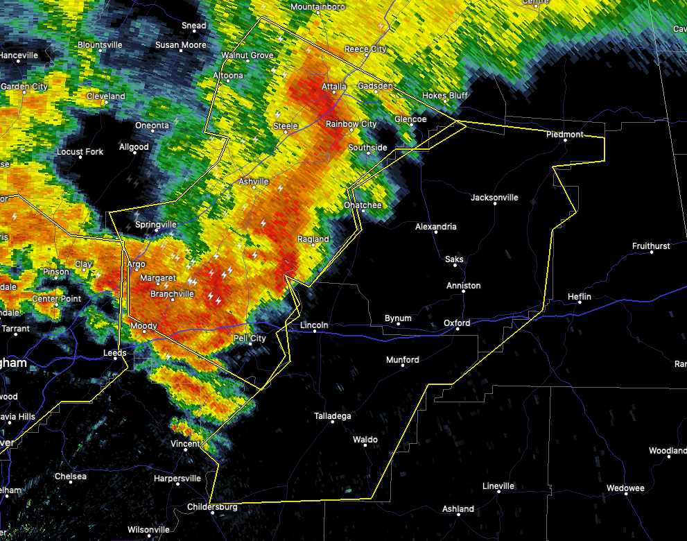
* Severe Thunderstorm Warning for…
Talladega County in east central Alabama…
Calhoun County in east central Alabama…
* Until 200 PM CDT.
* At 105 PM CDT, severe thunderstorms were located along a line
extending from Attalla to Moody, moving southeast at 35 mph.
HAZARD…60 mph wind gusts.
SOURCE…Radar indicated.
IMPACT…Expect damage to roofs, siding, and trees.
* Locations impacted include…
Anniston, Oxford, Talladega, Jacksonville, Childersburg, Piedmont,
Cobb Town, West End-Cobb Town, Fort McClellan, Saks, Lincoln,
Glencoe, Weaver, Riverside, Vincent, Munford, Ohatchee, Hobson
City, Waldo and Alpine Bay Resort.
PRECAUTIONARY/PREPAREDNESS ACTIONS…
For your protection move to an interior room on the lowest floor of a
building.
Prepare immediately for large hail and damaging winds. People outside
should move immediately to shelter inside a strong building. Stay
away from windows.
These storms have a history of producing widespread wind damage
across Blount and St. Clair Counties. SEEK SHELTER NOW inside a
sturdy structure and stay away from windows! Large hail and damaging
winds and continuous cloud to ground lightning is occurring with
these storms. Move indoors immediately.
Lightning is one of nature’s leading killers. Remember, if you can
hear thunder, you are close enough to be struck by lightning.
Torrential rainfall is occurring with these storms, and may lead to
flash flooding. Do not drive your vehicle through flooded roadways.
Category: Alabama's Weather, ALL POSTS, Severe Weather
About the Author (Author Profile)
Scott Martin is an operational meteorologist, professional graphic artist, musician, husband, and father. Not only is Scott a member of the National Weather Association, but he is also the Central Alabama Chapter of the NWA president. Scott is also the co-founder of Racecast Weather, which provides forecasts for many racing series across the USA. He also supplies forecasts for the BassMaster Elite Series events including the BassMaster Classic.Subscribe
If you enjoyed this article, subscribe to receive more just like it.


