At Midday: Rather Quiet & Hot for Central AL, Gonzalo is Weaker, TD-8 Continues on Path to South Texas
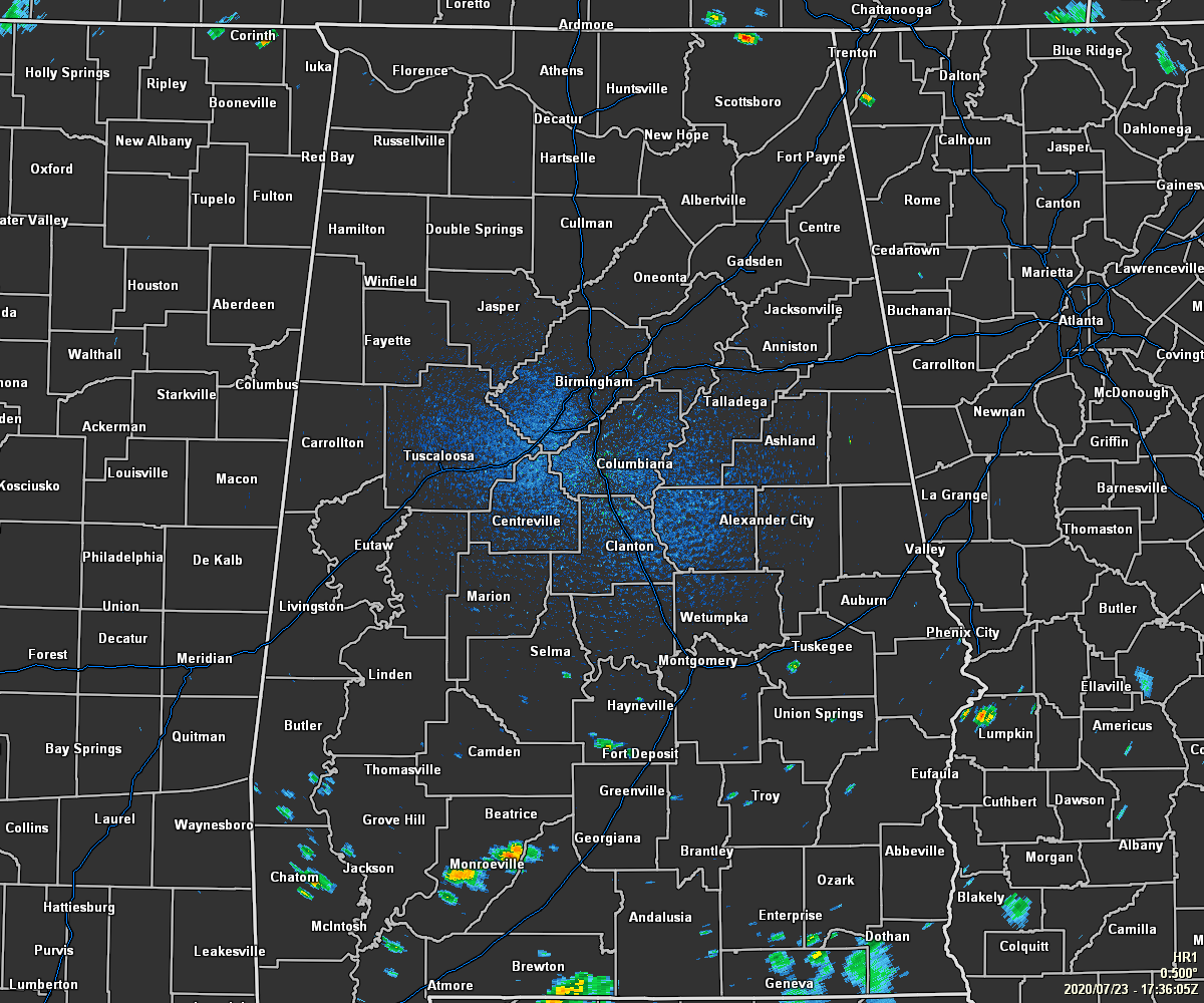
It’s a rather quiet midday today compared to what we saw just 24 hours ago across Central Alabama as we have only a few isolated showers over the southern portions of the area and one that has popped up in the northern parts of Jackson County in the northern parts of North Alabama. Temperatures were in the mid-80s to the lower 90s as of the 12:00 pm Round-Up. Tuscaloosa, Montgomery, and Anniston were tied as the hot spots at 90 degrees. Haleyville and Marion were tied as the cool spots at 86 degrees. Birmingham was sitting at 88 degrees.
It will continue to get hotter as we move further into the afternoon hours, but we’ll also see more isolated to scattered showers and thunderstorms develop as well. At this point, the higher concentration of the scattered activity looks to take place over the extreme northern parts of Central Alabama and up into North Alabama, along with the extreme southern parts of Central Alabama and down into South Alabama. The central Parts of Central Alabama will mainly stay dry with only a few isolated showers and storms possible. Afternoon highs will be in the lower to mid-90s, and with a good bit of humid air in place, heat index values will be in the 100-105 degree range. While widespread severe weather is not expected, a few storms may become strong to briefly severe with gusty winds being the main threat.
Any shower and storm activity will begin to wane during the evening and into the late-night hours with skies becoming partly cloudy. It will continue to be humid and overnight lows will be in the lower to mid-70s.
Same song, different verse for the weather on Friday… We’ll continue to be hot and humid with highs reaching the lower to mid-90s and heat indices in the 100-105 degree range. There will be a good bit of sunshine to start the day, but clouds will build and scattered showers and thunderstorms will form during the late morning through the afternoon and into the early evening. Once again the extreme northern and southern parts of Central Alabama will see the highest concentration of activity.
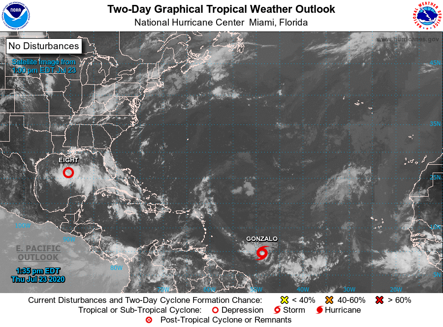
Tropical Depression Eight continues to move west-northwest at 7 MPH with winds holding at 35 MPH. It is expected to continue moving west to west-northwest and the center of the depression is expected to move across the northwestern Gulf of Mexico today and Friday and make landfall along the Texas coast on Saturday. Slow strengthening is expected, and the depression could become a tropical storm during the next 12 to 24 hours. Dangerous rip currents and rough surf continue to be likely along the AL/W FL Gulf Coast through at least Friday night.
Tropical Storm Gonzalo has actually weakened as of the latest update from the NHC, with winds down to 60 MPH and the minimum central pressure up to 1000 MB. Movement is to the west at 14 MPH. A west to west-northwestward motion with an increase in forward speed is expected through the weekend. On the forecast track, the center of Gonzalo will approach the southern Windward Islands Friday night and move across the islands Saturday and Saturday evening. Some re-strengthening is possible during the next couple of days, and there is still a chance that Gonzalo could become a hurricane.
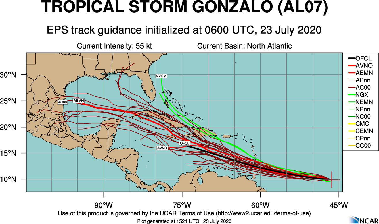
We are at least one-week away before Gonzalo likely makes it into the Gulf of Mexico. Most of the model members have it continuing on a west-northwestward track and moving either onto the Mexican or extra southern Texas Gulf Coast. We do see a few members moving it northward into the Florida Panhandle and up into South Alabama. At this point, it is simply too far out to be specific on where Gonzalo will go or if it will survive the trip. We’ll keep our eyes on Gonzalo and will keep you updated.
Category: Alabama's Weather, ALL POSTS, Tropical
About the Author (Author Profile)
Scott Martin is an operational meteorologist, professional graphic artist, musician, husband, and father. Not only is Scott a member of the National Weather Association, but he is also the Central Alabama Chapter of the NWA president. Scott is also the co-founder of Racecast Weather, which provides forecasts for many racing series across the USA. He also supplies forecasts for the BassMaster Elite Series events including the BassMaster Classic.Subscribe
If you enjoyed this article, subscribe to receive more just like it.


