Hurricane Hunters Investigating TD-8; Tropical Storm Formation Likely Tonight
SUMMARY OF 700 PM CDT…0000 UTC…INFORMATION
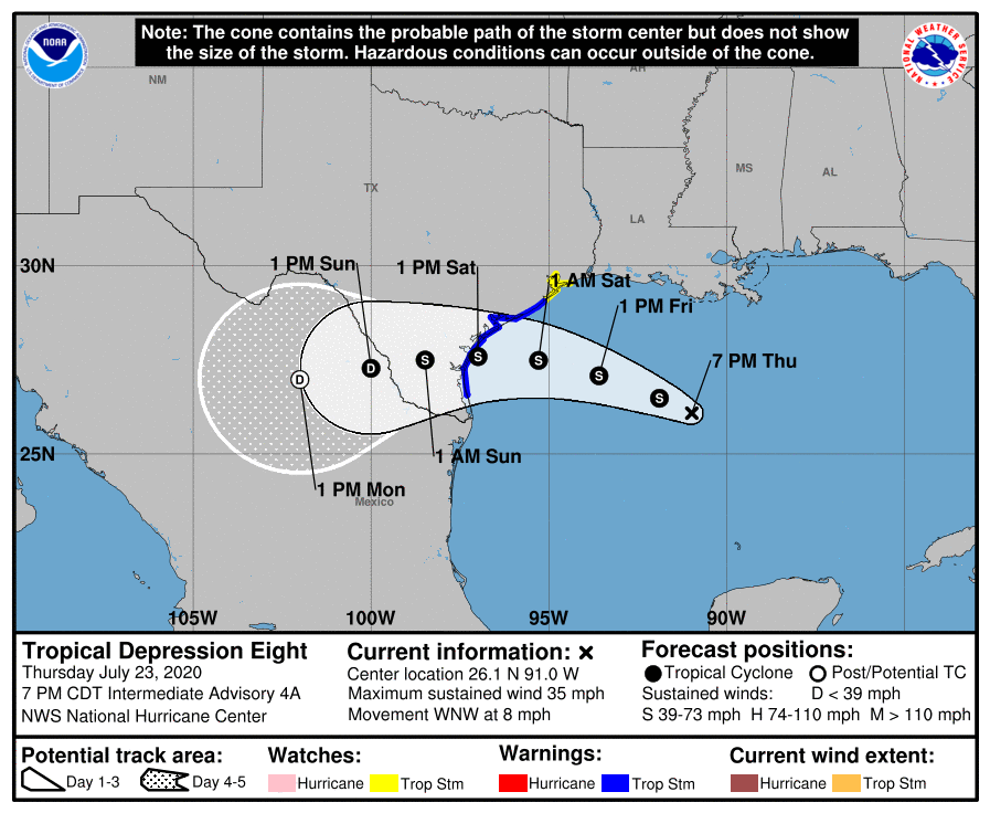
LOCATION…26.1N 91.0W
ABOUT 370 MI…590 KM ESE OF PORT OCONNOR TEXAS
ABOUT 410 MI…660 KM ESE OF CORPUS CHRISTI TEXAS
MAXIMUM SUSTAINED WINDS…35 MPH…55 KM/H
PRESENT MOVEMENT…WNW OR 285 DEGREES AT 8 MPH…13 KM/H
MINIMUM CENTRAL PRESSURE…1003 MB…29.62 INCHES
SUMMARY OF WATCHES AND WARNINGS IN EFFECT:
A Tropical Storm Warning is in effect for…
* Port Mansfield to San Luis Pass Texas
A Tropical Storm Watch is in effect for…
* San Luis Pass to High Island Texas
DISCUSSION AND OUTLOOK
At 700 PM CDT (0000 UTC), the center of Tropical Depression Eight was located near latitude 26.1 North, longitude 91.0 West. The depression is moving toward the west-northwest near 8 mph (13 km/h), and a west-northwestward to westward motion is expected during the next couple of days. On the forecast track, the center of the depression is expected to move across the northwestern Gulf of Mexico tonight and Friday and make landfall along the Texas coast on Saturday.
Maximum sustained winds are near 35 mph (55 km/h) with higher gusts. Strengthening is expected during the next 48 hours, and the depression is expected to become a tropical storm tonight.
The estimated minimum central pressure based on data from the NOAA Hurricane Hunters is 1003 MB (29.62 inches).
HAZARDS AFFECTING LAND
WIND: Tropical Storm conditions are expected in the warning area by Friday night or Saturday morning. Tropical storm conditions are possible within the watch area by Friday night or Saturday morning.
RAINFALL: The tropical depression is expected to produce 3 to 5 inches of rain with isolated maximum totals of 10 inches through Monday along the Gulf Coast of the United States from Louisiana to south Texas, and inland to the Mexican states of Coahuila, Nuevo Leon, and northern Tamaulipas. This rain may result in life-threatening flash flooding, rapid rises on small streams, and isolated minor-to-moderate river flooding.
SURF: Swells generated by the tropical cyclone are expected to increase and affect much of the Texas and Louisiana coasts during the next few days. These swells are likely to cause life-threatening surf and rip current conditions.
About the Author (Author Profile)
Scott Martin is an operational meteorologist, professional graphic artist, musician, husband, and father. Not only is Scott a member of the National Weather Association, but he is also the Central Alabama Chapter of the NWA president. Scott is also the co-founder of Racecast Weather, which provides forecasts for many racing series across the USA. He also supplies forecasts for the BassMaster Elite Series events including the BassMaster Classic.Subscribe
If you enjoyed this article, subscribe to receive more just like it.


