A Late-Night Look at a Weakening Category 1 Hurricane Hanna
SUMMARY OF 1000 PM CDT…0300 UTC…INFORMATION
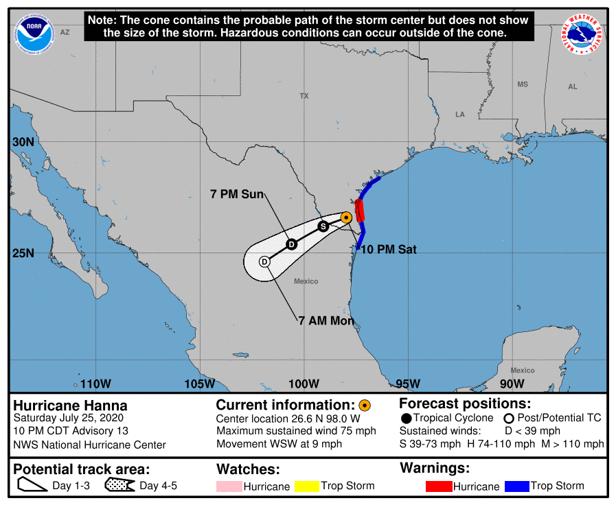
LOCATION…26.6N 98.0W
ABOUT 30 MI…50 KM NNE OF MCALLEN TEXAS
ABOUT 35 MI…60 KM W OF PORT MANSFIELD TEXAS
MAXIMUM SUSTAINED WINDS…75 MPH…120 KM/H
PRESENT MOVEMENT…WSW OR 250 DEGREES AT 9 MPH…15 KM/H
MINIMUM CENTRAL PRESSURE…979 MB…28.91 INCHES
WATCHES AND WARNINGS
A Storm Surge Warning is in effect for…
* Port Mansfield to Port O’Connor
A Hurricane Warning is in effect for…
* Port Mansfield to Baffin Bay Texas
A Tropical Storm Warning is in effect for…
* Barra el Mezquital Mexico to Port Mansfield Texas
* Baffin Bay to Port O’Connor Texas
FORECAST DISCUSSION
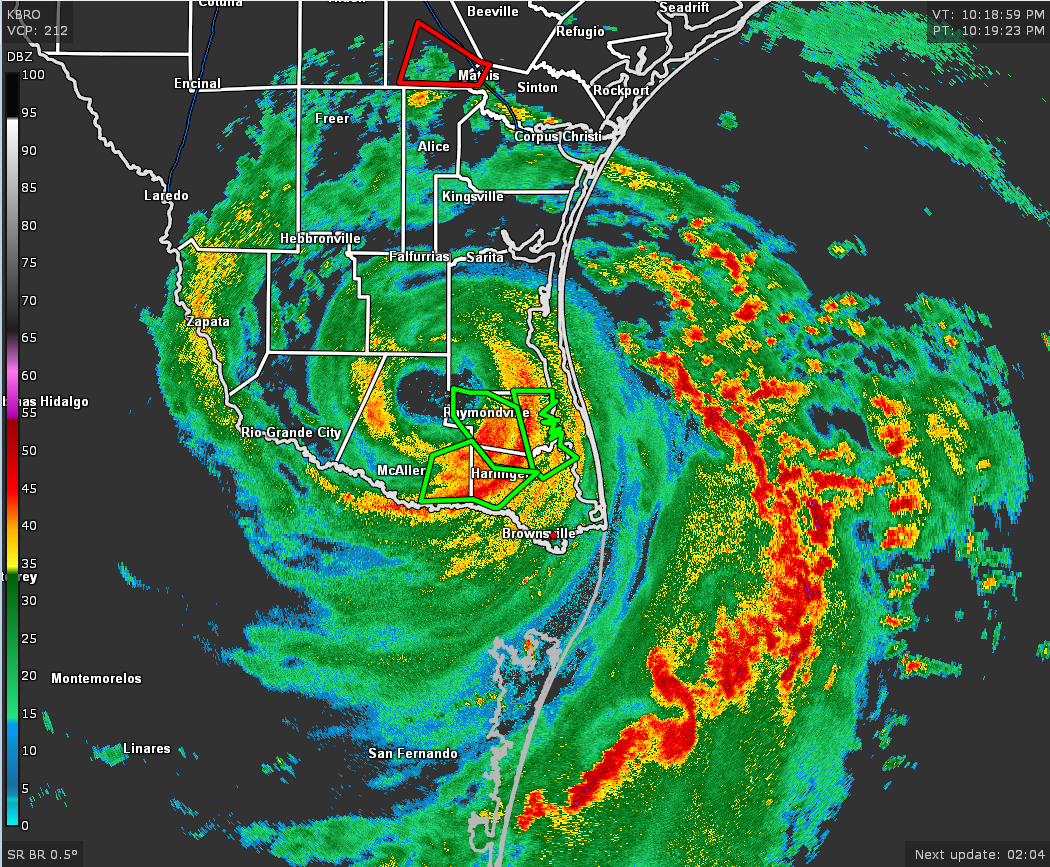
Hanna made landfall around 2200 UTC over Padre Island, Texas, and then made a second landfall a little more than an hour later in eastern Kenedy County, Texas. The estimated intensity was 80 kt for both of those landfalls. Since then, Hanna has been moving inland over southern Texas and has weakened. The initial intensity is lowered to 65 kt for this advisory, based on Doppler radar velocity data and surface observations. Even though the hurricane has weakened some, it still has an impressive appearance in radar images with an eye, eyewall, and rainbands evident.
The storm is moving west-southwestward at 8 kt, steered by a mid-level ridge situated to its north over the central United States. This motion should continue, taking Hanna across extreme southern Texas overnight and across northeastern Mexico on Sunday. The new NHC track forecast is just a little south of the previous one, trending toward the latest consensus models.
Now that Hanna is inland, rapid weakening is forecast. Hanna should fall below hurricane strength in the next few hours and weaken to a tropical depression by late Sunday. Hanna is forecast to dissipate over the rugged terrain of Mexico on Monday.
KEY MESSAGES
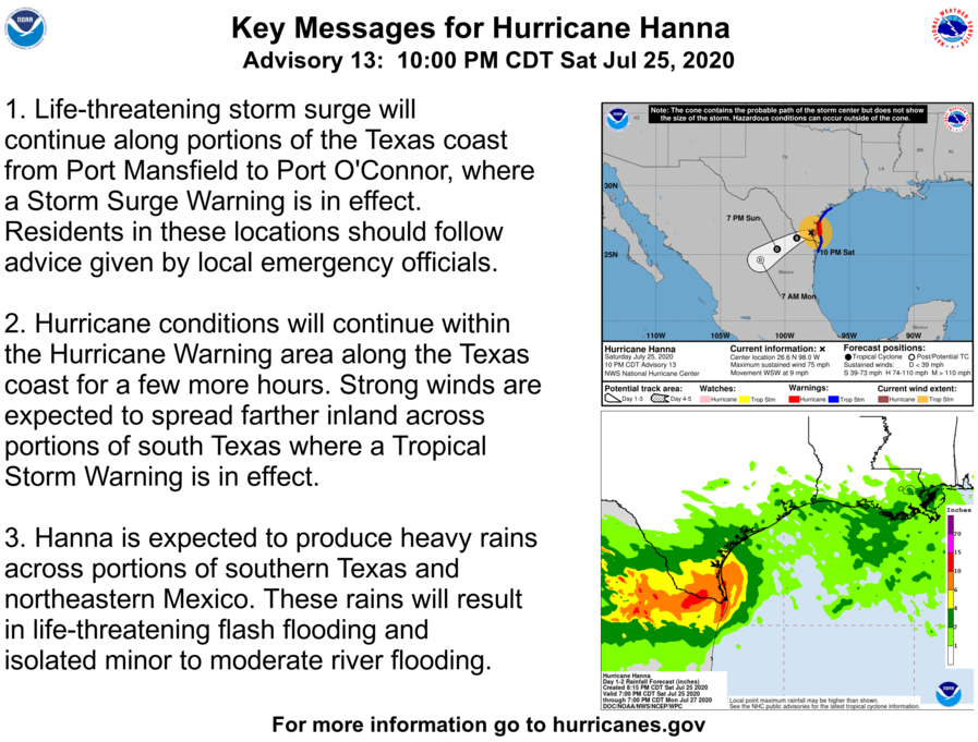
1. Life-threatening storm surge will continue along portions of the Texas coast from Port Mansfield to Port O’Connor, where a Storm Surge Warning is in effect. Residents in these locations should follow the advice given by local emergency officials.
2. Hurricane conditions will continue within the Hurricane Warning area along the Texas coast for a few more hours. Strong winds are expected to spread farther inland across portions of south Texas where a Tropical Storm Warning is in effect.
3. Hanna is expected to produce heavy rains across portions of southern Texas and northeastern Mexico. These rains will result in life-threatening flash flooding and isolated minor to moderate river flooding.
Category: ALL POSTS, Severe Weather, Tropical
About the Author (Author Profile)
Scott Martin is an operational meteorologist, professional graphic artist, musician, husband, and father. Not only is Scott a member of the National Weather Association, but he is also the Central Alabama Chapter of the NWA president. Scott is also the co-founder of Racecast Weather, which provides forecasts for many racing series across the USA. He also supplies forecasts for the BassMaster Elite Series events including the BassMaster Classic.Subscribe
If you enjoyed this article, subscribe to receive more just like it.


