Several Showers & Storms Out There At Midday; Eyes On the Tropics
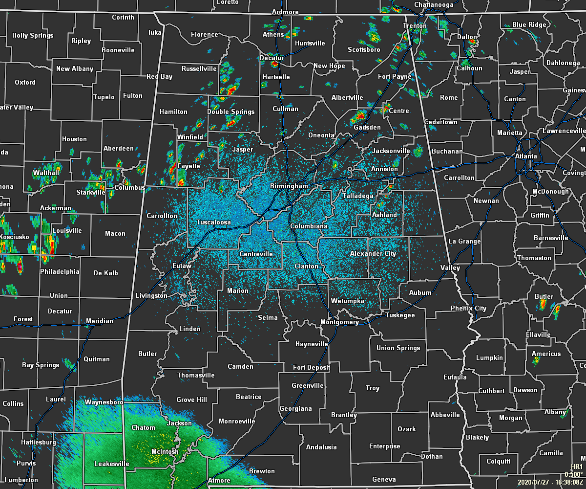
As of 11:40 am, convective clouds have already started to build across parts of the area, and underneath some of those clouds, we have some scattered showers and storms falling. Nearly all of the activity is falling north and west of the I-59 corridor over the northwestern parts of the area, especially over parts of Lamar, Fayette, Marion, and Winston counties. There is also a nice-sized shower over the northern parts of Etowah County at this time. There are more scattered showers and storms over parts of North Alabama as well.
Temperatures as of the 11:00 am Round-Up were in the 80s across Central Alabama with many reporting stations showing partly sunny to mostly sunny skies. Anniston, Troy, and Tuscaloosa were tied as the warm spots at 87 degrees. Bessemer and Deopolis were tied as the cool spots at 83 degrees. Birmingham was sitting at 86 degrees.
Skies will eventually become partly to mostly cloudy across the area and there will be more scattered showers and storms that will form with the heating of the day. While widespread severe weather is not expected, we could see a storm or two briefly become strong with gusty winds and small hail as the main threats. Afternoon highs will be in the upper 80s to the lower 90s.
Showers and storms will begin to diminish after the sun goes down and we lose the heating from the daylight hours. Skies will eventually become mostly cloudy as the rain should be done with once we get into the late-night and overnight hours. Lows will be in the lower to mid-70s.
Moisture levels will increase across Central Alabama as tropical moisture will move up into the area from the south and southwest. That will greatly increase the odds of mainly afternoon and evening showers and storms with rain chances maxing out at 60-70% across the area from north to south. Highs will be a little cooler with the cloud cover and rain-cooled air, only reaching the mid to upper 80s, but the higher humidity levels will make it feel extremely muggy outdoors.
THE TROPICS
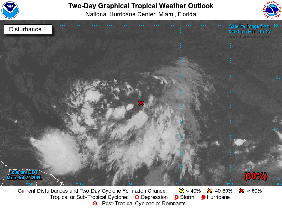
INVEST 92L… SOON TO BE ISAIAS (EE SAH EE AS)
Shower activity associated with a broad area of low pressure located a little more than 1000 miles east of the Windward Islands has become a little less organized since last night. However, environmental conditions are still expected to become more favorable for development in a day or two and a tropical depression or tropical storm will likely form within the next couple of days. The system is forecast to move westward to west-northwestward at 15 to 20 MPH and could begin to affect portions of the Lesser Antilles on Wednesday or Wednesday night.
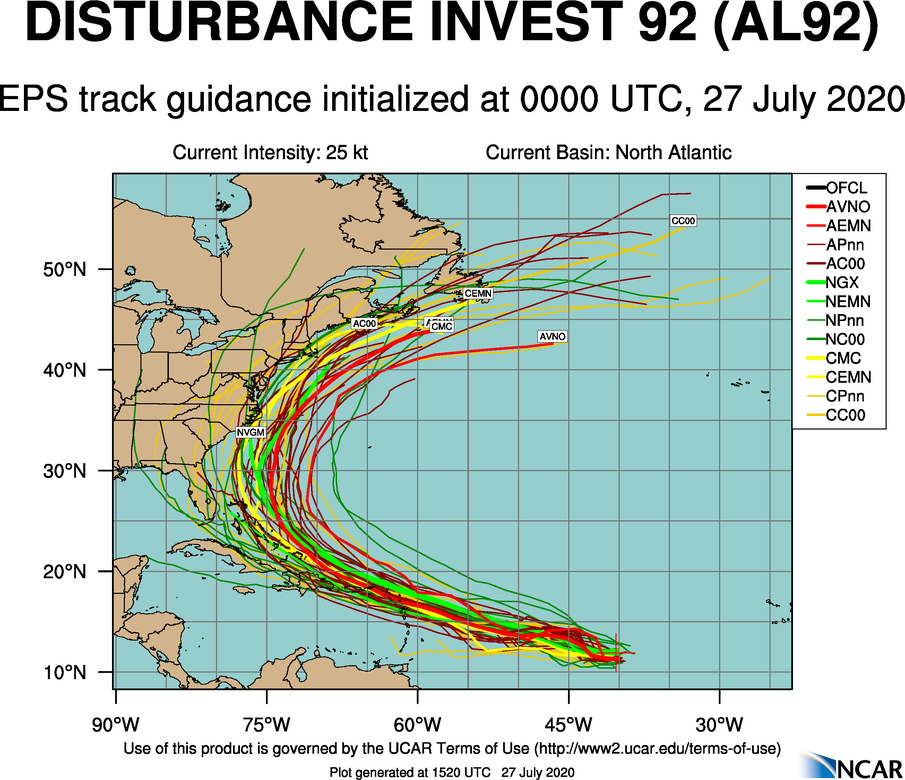
This disturbance looks likely to become a hurricane within the next 3-4 days and is expected to pass near or just north of the Leeward Islands and Puerto Rico before gaining latitude and making a hard right turn just east of the US East Coast by next week. At this point, odds look in favor of this not being a Gulf of Mexico storm, but we’ll be able to get better data once this disturbance gets organized and becomes tropical in nature. Stay tuned.
Category: Alabama's Weather, ALL POSTS, Tropical
About the Author (Author Profile)
Scott Martin is an operational meteorologist, professional graphic artist, musician, husband, and father. Not only is Scott a member of the National Weather Association, but he is also the Central Alabama Chapter of the NWA president. Scott is also the co-founder of Racecast Weather, which provides forecasts for many racing series across the USA. He also supplies forecasts for the BassMaster Elite Series events including the BassMaster Classic.Subscribe
If you enjoyed this article, subscribe to receive more just like it.


