A Few Strong to Severe Storms Remain Possible for This Afternoon and Into the Evening
An update on Hurricane Isaias will be out at or just after 1:00 pm… Stay tuned!
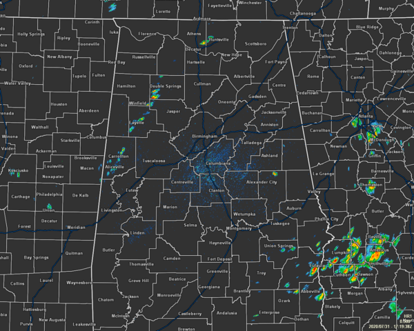
TAKING A LOOK OUT THE WINDOW AT 12:20 PM
It is mostly quiet across Central Alabama during the midday hour, but we do have a few showers that have formed in a rough broken line from Double Springs to Fayette to Carrollton. There are a few more showers down in the extreme southeastern parts of the area as well, but the good news is that none of these are strong at this point.
Temperatures were ranging from around 86 degrees in Auburn to as hot as 91 degrees in Birmingham, Montgomery, and Troy. We’re getting pretty close to the forecasted highs for today, but not quite there yet as highs will be in the 88-93 degree range throughout the area.
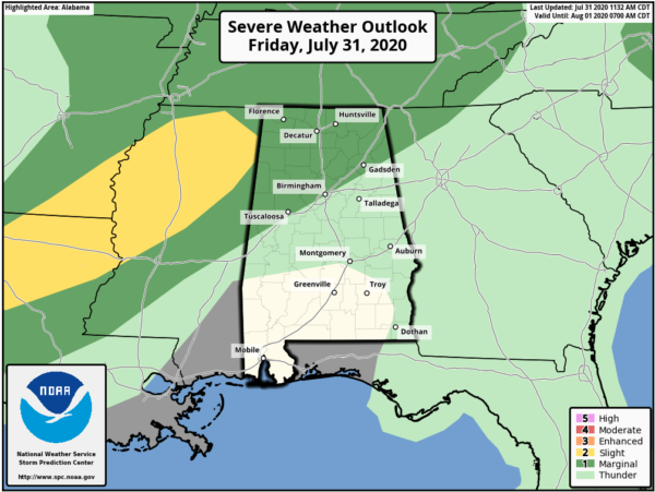
A FEW STRONG TO SEVERE STORMS ARE POSSIBLE THIS AFTERNOON
Parts of Central Alabama and all of North Alabama remain in a Level 1 Marginal Risk for severe storms throughout the rest of the afternoon and into the evening hours. The Marginal Risk includes locations north of a line from Tuscaloosa to Birmingham to Jacksonville. Damaging winds up to 60 MPH will be the main threat with any strong to severe storm, with the window for the potential of those occurring will be from now through 7:00 pm tonight. Storms will be scattered in nature, so not everyone will see rain, but the highest concentration of those taking place over the northern half of the area. Highs will be hot reaching the upper 80s to the lower 90s and heat indices in the 100-104 degree range.
Coverage will diminish a good deal for the evening through the overnight hours for much of Central Alabama, but a few showers and storms remain possible along and north of the I-59 corridor. No severe storms are expected during the late-night and through the overnight. Lows will be in the lower to mid-70s across the area.
MUCH OF THE SAME FOR YOUR SATURDAY
We continue to have scattered to numerous showers and thunderstorms in the forecast mainly during the afternoon and evening hours across Central Alabama, but much of these will be more typical of summertime thunderstorms. There may be a strong to severe storm or two up in the Tennessee Valley, but none are expected at this time for Central Alabama. Highs will be in the lower 80s to the mid-90s from northwest to southeast across the area.
Category: Alabama's Weather, ALL POSTS, Severe Weather
About the Author (Author Profile)
Scott Martin is an operational meteorologist, professional graphic artist, musician, husband, and father. Not only is Scott a member of the National Weather Association, but he is also the Central Alabama Chapter of the NWA president. Scott is also the co-founder of Racecast Weather, which provides forecasts for many racing series across the USA. He also supplies forecasts for the BassMaster Elite Series events including the BassMaster Classic.Subscribe
If you enjoyed this article, subscribe to receive more just like it.


