It’s a Hot One with Showers and Storms Beginning to Form Before Midday
WHAT’S UP WITH THE WEATHER JUST BEFORE MIDDAY
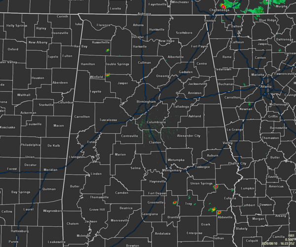
AT 11:22 AM – A few showers have started popping up across the area as we are making our way to lunchtime in Central Alabama. We have a small shower over the northwestern corner of Walker County to go along with a few showers down over portions of Barbour, Bullock, and Pike counties in the southeastern parts of the area. At this point, the rest of the area is dry, but that may change rather quickly.
Temperatures as of 11:30 am were in the upper 80s to the lower 90s already throughout the area. Cullman was the cool spot at 89 degrees while Tuscaloosa is already up to 93 degrees as the hot spot. Birmingham was at 91 degrees.
WEATHER FOR THE REST OF YOUR MONDAY
We will see the radar become a little more splotchy as showers and thunderstorms will continue to form throughout the heating of the day, with the highest concentrations of those occurring in the eastern half of the area. No matter where you are in Central Alabama, it will be a hot and muggy one with afternoon highs reaching the mid to upper 90s with heat indices in the 100-105 degree range. Rain chances across the area range from 30% in the west to 50% around the I-65 corridor to over right at 60% in the extreme eastern parts of the area.
Showers and storms will continue across portions of Central Alabama during the evening and into the late-night hours, before finally calming down for the overnight hours. We’ll have partly cloudy skies after the showers have been put to bed. Lows will be in the lower to mid-70s.
HIGHER COVERAGE OF SHOWERS & STORMS ON TUESDAY
Hot, humid with a good chance of showers and thunderstorms mainly during the afternoon and evening hours, with rain chances topping out around 50-60% throughout Central Alabama from west to east. For the extreme southeastern parts of the area, those showers and storms may start an hour or so earlier and will be more likely. Afternoon highs will be in the mid to upper 90s with heat indices reaching 100-105 degrees.

THE TROPICS
Showers and thunderstorms associated with Invest 95L are located about 600 miles west-southwest of the Cabo Verde Islands have changed little in organization since yesterday. Environmental conditions are expected to be somewhat conducive for development to occur, and a tropical depression could form during the next day or two while the disturbance moves generally westward to west-northwestward at 10 to 15 mph across the tropical Atlantic. Conditions are forecast to become less conducive for development by the end of the week.
* Formation chance through 48 hours…medium…60 percent.
* Formation chance through 5 days…medium…60 percent.
RADAR UPDATE
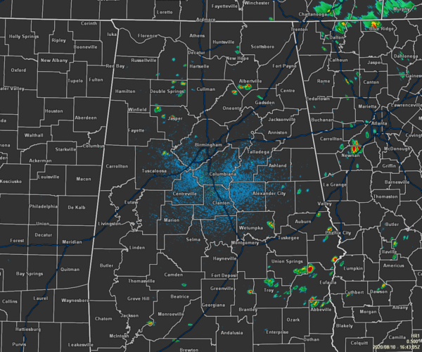
So I just finished typing the post and here is what the radar looks like as of 11:43 am. Look how quickly these showers are forming.
Category: Alabama's Weather, ALL POSTS, Tropical
About the Author (Author Profile)
Scott Martin is an operational meteorologist, professional graphic artist, musician, husband, and father. Not only is Scott a member of the National Weather Association, but he is also the Central Alabama Chapter of the NWA president. Scott is also the co-founder of Racecast Weather, which provides forecasts for many racing series across the USA. He also supplies forecasts for the BassMaster Elite Series events including the BassMaster Classic.Subscribe
If you enjoyed this article, subscribe to receive more just like it.


