A Few Showers Popping Up Already Before Midday… More to Follow
AN 11:15 AM LOOK OUT THE WINDOW
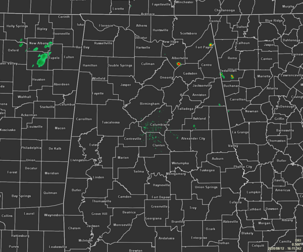
We are already starting to see a few isolated showers popping up over the northeastern parts of the area, especially over the extreme northwestern part of Etowah County and up into southern Marshall County. A few more are dotting the screen over portions of Clay and Cleburne counties. The rest of the area is quiet for now… keyword… for now.
Temperatures as of the 11:00 am RoundUp were in the 80s across the area. The hot spot was Gadsden at 89 degrees. Birmingham was at 87 degrees. Prattville was the cool spot at 82 degrees.
WEATHER FOR THE REST OF YOUR WEDNESDAY
Similar to what we saw on Tuesday, we’ll have scattered to numerous showers and thunderstorms form during the afternoon and continue into the evening hours before dissipating somewhat by the late-night and overnight hours. Also, similar to yesterday, a few of these storms may become strong to severe with brief damaging wind gusts and hail up to quarter size possible. Skies will be partly to mostly cloudy with highs reaching the lower to mid-90s across the area with heat indices maxing out in the 100-105 degree range. Lows tonight will be in the lower to mid-70s.
MUCH HIGHER RAIN CHANCES FOR THURSDAY
While much of the morning will stay dry across Central Alabama, numerous showers and thunderstorms will begin developing across the area with rain chances maxing out over 70% by late afternoon. Once again, a few storms may briefly become strong with gusty winds and some small hail. It will be a little cooler across the area with the added cloud cover and increased rain activity, but humidity levels will remain rather high to make it feel muggy. Highs will be in the upper 80s to the lower 90s.
UPDATE ON TROPICAL DEPRESSION ELEVEN
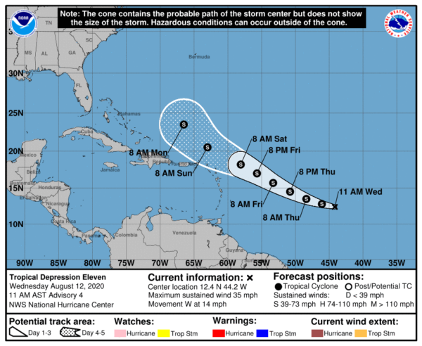
As of 10:00 am CDT, TD-11 was located around 1320 miles to the east-southeast of the Northern Leeward Islands and was moving to the west at 14 MPH. It is currently just below tropical storm strength with sustained winds at 35 MPH. Gradual strengthening is forecast during the next 48 hours, and the depression is expected to become Tropical Storm Josephine later today. A turn toward the west-northwest at a similar forward speed is expected tonight, with this motion continuing through the rest of the week. After that, conditions will become less than friendly for the system and possibly could weaken it back to a depression or even dissipate it. We’ll have to wait and see.
Category: Alabama's Weather, ALL POSTS, Severe Weather, Tropical
About the Author (Author Profile)
Scott Martin is an operational meteorologist, professional graphic artist, musician, husband, and father. Not only is Scott a member of the National Weather Association, but he is also the Central Alabama Chapter of the NWA president. Scott is also the co-founder of Racecast Weather, which provides forecasts for many racing series across the USA. He also supplies forecasts for the BassMaster Elite Series events including the BassMaster Classic.Subscribe
If you enjoyed this article, subscribe to receive more just like it.


