

Marco Moving North-Northwestward Across the Southern Gulf of Mexico
NHC UPDATE SUMMARY OF 10:00 PM CDT INFORMATION
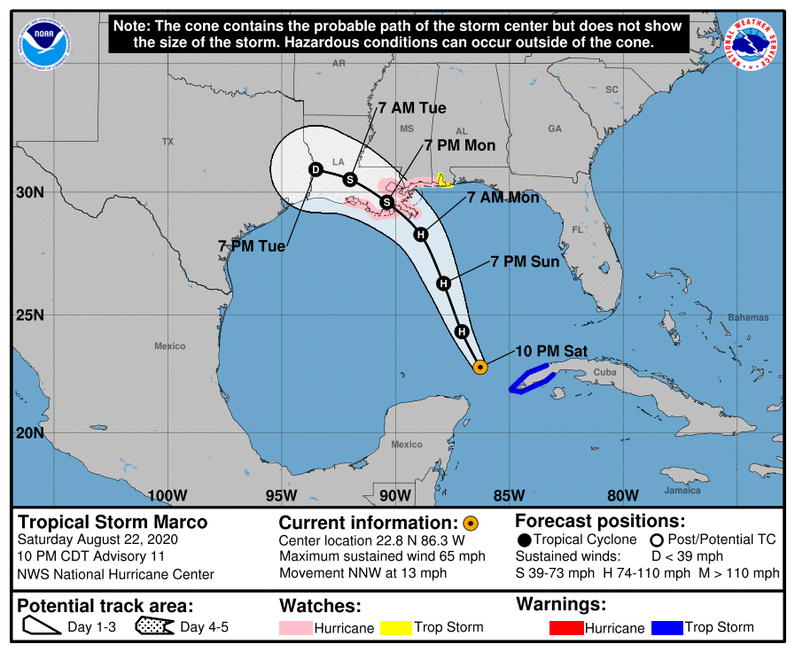
LOCATION…22.8N 86.3W
ABOUT 110 MI…175 KM NW OF THE WESTERN TIP OF CUBA
ABOUT 470 MI…755 KM SSE OF THE MOUTH OF THE MISSISSIPPI RIVER
MAXIMUM SUSTAINED WINDS…65 MPH…100 KM/H
PRESENT MOVEMENT…NNW OR 335 DEGREES AT 13 MPH…20 KM/H
MINIMUM CENTRAL PRESSURE…994 MB…29.36 INCHES
WATCHES AND WARNINGS
A Storm Surge Watch is in effect for…
* Sabine Pass to the Alabama/Florida border
* Lake Pontchartrain, Lake Maurepas, Lake Borgne, and Mobile Bay
A Hurricane Watch is in effect for…
* Intracoastal City Louisiana to the Mississippi/Alabama border
* Lake Pontchartrain, Lake Maurepas, and Metropolitan New Orleans
A Tropical Storm Warning is in effect for…
* Province of Pinar del Rio Cuba
A Tropical Storm Watch is in effect for…
* Mississippi/Alabama border to the Alabama/Florida border
DISCUSSION AND OUTLOOK
At 1000 PM CDT (0300 UTC), the center of Tropical Storm Marco was located near latitude 22.8 North, longitude 86.3 West. Marco is moving toward the north-northwest near 13 mph (20 km/h). Marco is forecast to continue moving north-northwestward across the central Gulf of Mexico on Sunday and will approach the northern Gulf Coast on Monday. A gradual turn toward the west with a decrease in forward speed is expected after Marco moves inland on Monday and on Tuesday.
Data from an Air Force Reserve Hurricane Hunter aircraft indicate that the maximum sustained winds remain near 65 mph (100 km/h) with higher gusts. Some strengthening is anticipated and Marco is forecast to become a hurricane on Sunday. Marco is expected to be at or near hurricane strength when it approaches the northern Gulf Coast on Monday. Rapid weakening is expected after Marco moves inland.
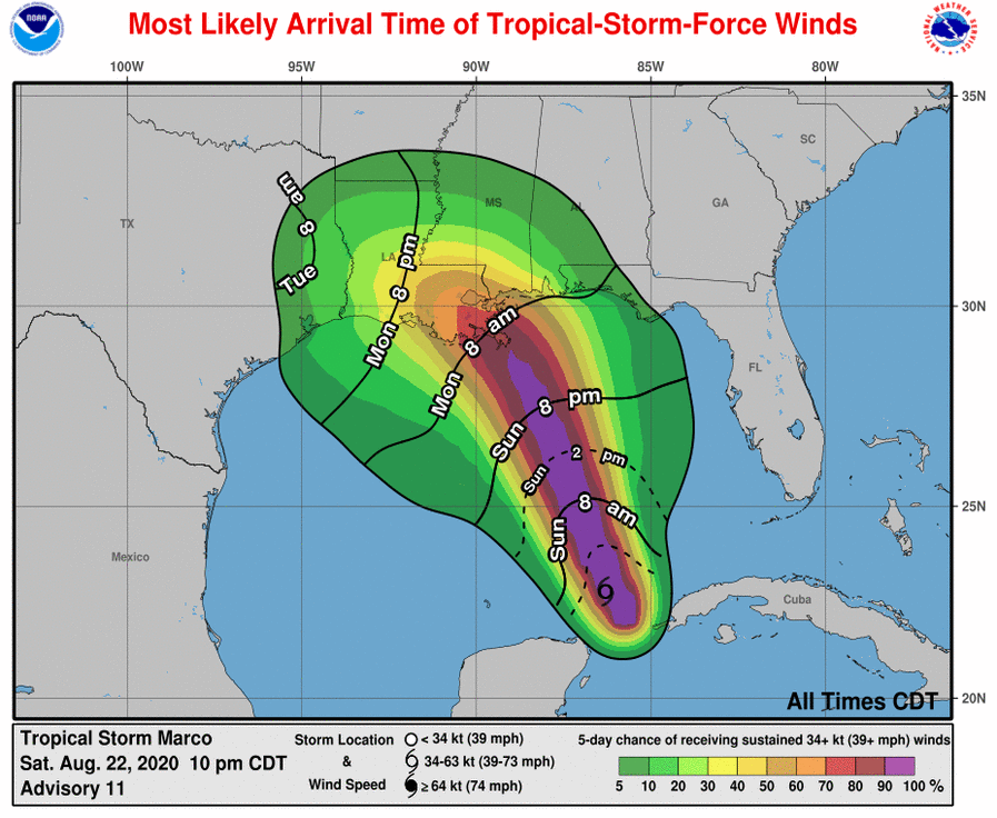
Tropical-storm-force winds extend outward up to 70 miles (110 km) from the center.
The estimated minimum central pressure based on data from the Air Force reconnaissance plane is 994 MB (29.36 inches).
HAZARDS AFFECTING LAND
STORM SURGE: The combination of a dangerous storm surge and the tide will cause normally dry areas near the coast to be flooded by rising waters moving inland from the shoreline. The water could reach the following heights above ground somewhere in the indicated areas if the peak surge occurs at the time of high tide…
Grand Isle LA to the AL/FL Border including Lake Borgne and Mobile Bay…3-5 ft
Lake Pontchartrain and Lake Maurepas…2-4 ft
Sabine Pass to Grand Isle LA…2-4 ft
The deepest water will occur along the immediate coast in areas of onshore winds, where the surge will be accompanied by large and destructive waves. Surge-related flooding depends on the relative timing of the surge and the tidal cycle and can vary greatly over short distances. For information specific to your area, please see products issued by your local National Weather Service forecast office.
WIND: Hurricane conditions are possible within the hurricane watch area by midday Monday, with tropical storm conditions possible by early Monday. Tropical storm conditions are possible within the tropical storm watch area on Monday.
Tropical storm conditions are expected to continue within the warning area in Cuba through this evening.
RAINFALL: Marco is expected to produce the following rainfall accumulations through Tuesday:
Far western Cuba: 2 to 4 inches of rain, with isolated maximum amounts of 6 inches possible
Central U.S. Gulf Coast: 1 to 3 inches, isolated maximum amounts of 5 inches.
This rainfall may result in areas of flash and urban flooding along the Central U.S. Gulf Coast.
Category: Alabama's Weather, ALL POSTS, Severe Weather, Tropical
About the Author (Author Profile)
Scott Martin is an operational meteorologist, professional graphic artist, musician, husband, and father. Not only is Scott a member of the National Weather Association, but he is also the Central Alabama Chapter of the NWA president. Scott is also the co-founder of Racecast Weather, which provides forecasts for many racing series across the USA. He also supplies forecasts for the BassMaster Elite Series events including the BassMaster Classic.Subscribe
If you enjoyed this article, subscribe to receive more just like it.


