Sunday Weather Xtreme: A Tropical Twofer
We are watching a potentially unusual event unfolding in the Gulf of Mexico as we have two tropical threats at the same time in the Gulf. Let’s update you on what we know.
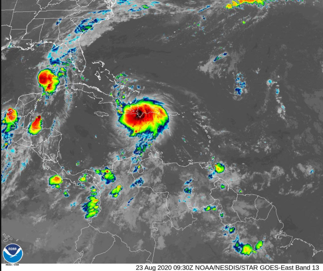
MARCO: As of early this morning, Marco is still a strong tropical storm. The center of the storm is located over the southeastern Gulf of Mexico, a little more than 400 miles south southeast of New Orleans. It is moving NNW at around 13 mph. Wind shear has diminished over the southeastern Gulf and water temperatures are very warm, around 29-30 degrees C. This will lead to some strengthening today, but dry air is lurking just to the south and west of the storm, and some of that will likely get ingested today, keeping Marco from intensifying quickly.
MARCO’S FUTURE: By early tomorrow, Hurricane Marco will be nearing the Mouth of the Mississippi River, about 120 miles south southeast of New Orleans. Top winds should be around 80-85 mph. The official forecast calls for a little weakening, but I wouldn’t be surprised if Marco holds its own even in the hours after landfall. The storm is expected to pass near or just west of New Orleans during the day on Monday, turning to the west as a surface ridge of high pressure developing over the Southeast blocks the forward progress of the storm. One other rare factor will be in play:
FUJIWARA EFFECT: Or should I say Fuju-Laura effect? When two tropical cyclones get within about 900 miles of each other, they can start to rotate around a common center, We may see that happening as Marco is rotated to the left after landfall.
MARCO’S IMPACTS: Southern Louisiana and parts of coastal Mississippi will experience tropical storm force to hurricane-force winds starting Monday morning, spreading westward across southern Louisiana during the day. 4-6 feet of storm surge will occur from Morgan City to near Ocean Springs, Mississippi and a Storm Surge Warning has been posted. Surge could reach 2-4 feet from Grand Isle all the way to the Louisiana/Texas border and along the rest of the Mississippi and all of the Alabama coast including Mobile Bay. 2-4 inches of rain will fall across coastal Alabama, Mississippi and southeastern Louisiana with some 4-6 inch amounts near New Orleans. Showers and storms will increase across the coastal waters today ahead of the storm, but the main feeder bands will move onshore from Panama City to Mobile Monday morning. Of course, rip currents will be a big problem, increasing today and especially Monday. Surf will be running 2-3 feet today, increasing too 4-6 feet tonight and to near 6 feet tomorrow. That rip current threat will continue Tuesday and Wednesday as Laura makes its move toward shore. South Alabama and Northwest Florida may also be in a favorable position for tornadoes on Monday. The SPC does not have any part of Alabama except for Mobile and Baldwin Counties outlooked for severe weather for Monday.
NEXT UP: LAURA: Now, enters Laura stage left. The tropical storm is over the Dominican Republic about to pass into Haiti, 600 miles southeast of Key West this morning, moving west-northwest at 18 mph. Top winds are 45 mph. The storm will spend today and tonight, traversing Haiti, crossing the Mona Passage, and then moving along the spine of Cuba from east to west. The storm should remain fairly steady state until it reaches the Gulf of Mexico Monday afternoon. It should become a hurricane Tuesday afternoon or evening when it is about where Marco is now, around 400 miles southeast of New Orleans. Laura does have the potential to significantly strengthen in the Gulf of Mexico on Monday and Tuesday. Laura is expected to make landfall on the southern Louisiana coast southwest of New Orleans Wednesday night, probably close to midnight.
LAURA’S IMPACTS: Laura will bring hurricane conditions to a small area near and to the east of the center Wednesday night as it makes landfall. The most likely spots to experience hurricane conditions will include Morgan City, Franklin, New Iberia, and Lafayette. Tropical-storm-force winds of 39 mph or greater will be felt over a large from along the coast of Mississippi through southeastern Louisiana. After landfall, the storm will turn northward through southern Mississippi. Tropical-storm-force winds will be felt into North Central Mississippi on Thursday. 5 to 10 more inches of rainfall and a potential storm surge of up to 6 feet or more will impact southern Louisiana starting Wednesday. For parts of the Louisiana and Mississippi coast, this will be a prolonged wind and water event that lasts upwards of at least 60 consecutive hours (from Monday morning until Wednesday evening). This means that wind damage could be worse than usual due to the prolonged wind event and that the surge damage could be worse than usual due to the length of the storm surge.
FOR THE ALABAMA/NW FLORIDA COAST: Unless Laura takes a more easterly course than forecast, the Alabama and Northwest Florida coasts should avoid tropical-storm-force winds from Laura. But with the uncertainty at this point, there is still a chance of that happening. Showers and storms will increase in the outer feeder bands along the Alabama and Northwest Florida coast Tuesday and Wednesday. Seas will increase to 6-7 feet and that rip current risk will be high.
FOR THE FLORIDA KEYS: Laura may bring a period of tropical storm conditions to the middle and lower Florida Keys on Monday afternoon and Monday evening. Tropical storm watches have been issued there.
FOR US IN CENTRAL AND NORTH ALABAMA: We’re starting off in the upper 60s this morning north of I-20 this morning, with lower 70s to the south. A few showers continue early this morning near an old frontal system that lies along I-59. Those showers covered parts of Cherokee, Etowah, and Calhoun Counties at 6 a.m. A few low clouds and some patchy fog will be experienced across the area this morning. As the surface ridge builds in from the east, Gulf moisture is being transported northward. A few isolated showers and storms will develop this afternoon as high temperatures warm into the upper 80s to near 90F. Some higher ran chances will edge up into southeastern portions of Central Alabama later this afternoon.
FOR MONDAY: As Marco moves toward shore, the outer rain shield of the storm will spread up into South Alabama. This rain shield cover overspread much of the state during the day.
SEVERE WEATHER MONDAY? The severe weather threat tomorrow should be limited to Mobile and Baldwin Counties, but thunderstorms that develop over South and Southeast Alabama Monday afternoon will have the chance to be strong. That activity could move up into Central Alabama Monday night. We will be monitoring it.
TUESDAY: Moore rain and storms will develop on Tuesday across Alabama in advance of Laura as it approaches from the south.
WEDNESDAY/THURSDAY: Rain and thunderstorms should thin a bit on Wednesday and be fairly non-existent on Thursday with Laura passing well to the west of Alabama.
FRIDAY INTO THE WEEKEND: As Laura exits to our northwest and north, it will allow a frontal system to approach from the northwest, increasing our rain chances on Friday.
MORE TROPICAL MISCHIEF IN THE GULF: The GFS spins up a brief tropical storm in the Bay of Campeche and southwestern Gulf of Mexico next weekend, taking it inland near Brownsville, TX. This system will have minor overall impact outside the Texas coast, and no impact on Alabama or Northwest Florida weather.
VOODOO LAND: Labor Day looks like it may be wet in Alabama with a frontal system draped across the area.
DANCING WITH THE STATS: Last month was the wettest July on record for new Orleans with 15.22 inches of rain in the month. It made the Crescent City the wettest reporting station in the U.S. last month. It ranks as the 17th wettest month of all time there.
SIDEWALK: Birmingham’s famed film festival will be a drive-in affair this year with the pandemic and all. Festival programmers have curated a fantastic lineup of films for this year. Get your tickets now! Go to sidewalk.com!
ADVERTISE WITH US: Deliver your message to a highly engaged audience by advertising on the AlabamaWX.com website. The site enjoyed 18.2 MILLION pageviews in the past 12 months. Don’t miss out! We can customize a creative, flexible, and affordable package that will suit your organization’s needs. Contact me, Bill Murray, at (205) 687-0782, and let’s talk.
WEATHERBRAINS: Monday night, we will be speaking with the head of NOAA, Dr. Neal Jacobs for the first part of the show. The second half will feature Dr. Jay Hobgood, a hurricane expert from Ohio State. Check out the show at www.WeatherBrains.com. You can also subscribe on iTunes. You can watch the show live at http://live.bigbrainsmedia.com/. You will be able to see the show on the James Spann 24×7 weather channel on cable or directly over the air on the dot 2 feed.
ON THIS DATE IN 1992: On Sunday morning, August 23rd, 1992, the warnings in South Florida were frantic. Strengthening Hurricane Andrew had top winds of 120 mph, making it a category 3 on the Saffir Simpson Scale. Located 380 miles west of Miami that morning, the storm was moving west at 15 mph. By 3:30 p.m., it was a category 4 storm with winds of 150 mph. That afternoon, Hurricane Andrew brought a 23 foot storm surge to Current Island in the Bahamas. Damage in the islands amounted to $250 million. Then as the night wore on, the small, distinct eye of Andrew is less than 100 miles away and would draw a bead on Homestead FL, south of Miami.
The National Hurricane Center in Coral Gables lay directly in the path of the dangerous Hurricane. A backup crew had flown to Washington DC in case communications from fortress-like facility in Coral Gables were interrupted. It would become the third category five hurricane too hit the United States later that night when it made landfall near Homestead, Florida, south of Miami. Follow my weather history tweets on Twitter. I am @wxhistorian at Twitter.com.
Category: Alabama's Weather, ALL POSTS, Tropical
About the Author (Author Profile)
Bill Murray is the President of The Weather Factory. He is the site's official weather historian and a weekend forecaster. He also anchors the site's severe weather coverage. Bill Murray is the proud holder of National Weather Association Digital Seal #0001 @wxhistorianSubscribe
If you enjoyed this article, subscribe to receive more just like it.


