Tropical Storm Laura Now Located Over Eastern Cuba
NHC UPDATE SUMMARY OF 7:00 PM CDT INFORMATION
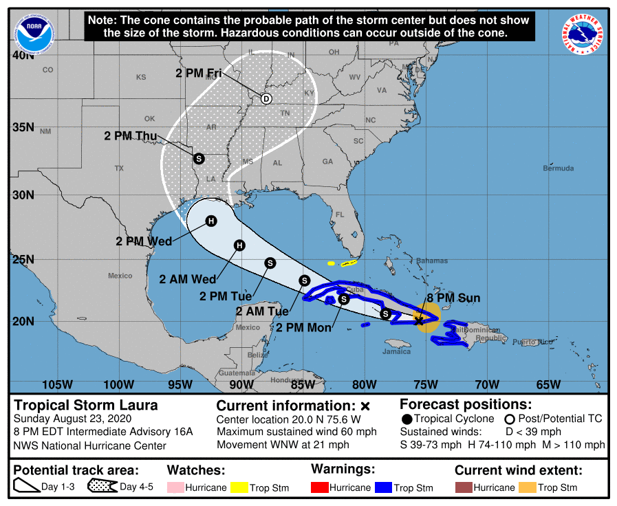
LOCATION…20.0N 75.6W
ABOUT 30 MI…55 KM W OF GUANTANAMO CUBA
ABOUT 175 MI…280 KM ESE OF CAMAGUEY CUBA
MAXIMUM SUSTAINED WINDS…60 MPH…95 KM/H
PRESENT MOVEMENT…WNW OR 285 DEGREES AT 21 MPH…33 KM/H
MINIMUM CENTRAL PRESSURE…1000 MB…29.53 INCHES
WATCHES AND WARNINGS
A Tropical Storm Warning is in effect for…
* Entire coast of Haiti
* Little Cayman and Cayman Brac
* Cuban provinces of Camaguey, Las Tunas, Holguin, Guantanamo, Santiago de Cuba, Granma, Ciego De Avila, Sancti Spiritus, Villa Clara, Cienfuegos, Matanzas, Mayabeque, La Habana, Artemisa, Pinar del Rio, and the Isle of Youth
A Tropical Storm Watch is in effect for…
* Florida Keys from Craig Key to Key West and the Dry Tortugas
DISCUSSION AND OUTLOOK
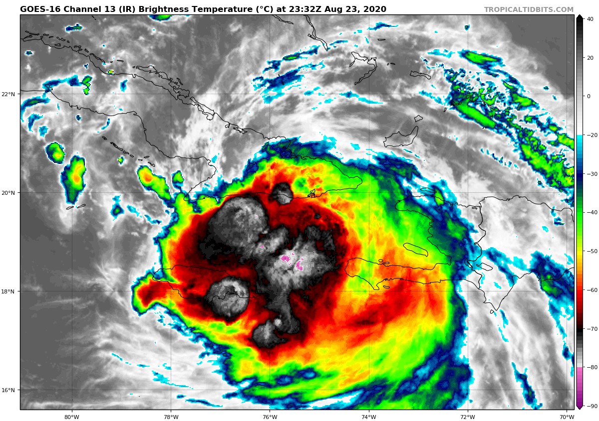
At 800 PM EDT (0000 UTC), the center of Tropical Storm Laura was located near latitude 20.0 North, longitude 75.6 West. Laura is moving toward the west-northwest near 21 mph (33 km/h), and this general motion with some decrease in forward speed is expected over the next couple of days. A turn toward the northwest is forecast by Wednesday. On the forecast track, the center of Laura will move near or over the southern coast Cuba tonight and Monday, and move over the southeastern Gulf of Mexico Monday night and Tuesday. Laura is expected to move over the central and northwestern Gulf of Mexico Tuesday night and Wednesday.
The maximum sustained winds are near 60 mph (95 km/h) with higher gusts. Little change in strength is forecast while Laura moves near the southern coast of Cuba tonight and Monday. However, strengthening is forecast after the storm moves over the Gulf of Mexico, and Laura is forecast to become a hurricane late Tuesday or Tuesday night.
Tropical-storm-force winds extend outward up to 140 miles (220 km) from the center. An observation in Guantanamo Bay, Cuba, recently measured sustained winds of 35 mph (56 km/h) and a wind gust to 44 mph (71 km/h).
The minimum central pressure based on surface observations is 1000 mb (29.53 inches).
HAZARDS AFFECTING LAND
RAINFALL: Laura is expected to produce the following storm total
rainfall accumulations through Tuesday:
Dominican Republic, Haiti, Jamaica, and Cuba: 4 to 8 inches, with
maximum amounts of 12 inches.
Cayman Islands: 2 to 4 inches, maximum amounts of 6 inches.
Florida Keys, Turks and Caicos and southeast Bahamas: 1 to 2 inches.
Across the Greater Antilles this heavy rainfall could lead to
life-threatening flash and urban flooding, and the potential for
mudslides.
By later Wednesday into Friday Laura is expected to produce rainfall of 5 to 10 inches, with isolated maximum amounts of 15 inches across portions of the west-central U.S. Gulf Coast near the Texas and Louisiana border north into portions of the lower Mississippi Valley. This rainfall could lead to flash, urban, and small stream flooding.
WIND: Tropical storm conditions are expected within portions of the warning area in Haiti through this evening. Tropical storm conditions are expected within portions of the warning area in Cuba later tonight through Monday. Tropical storm conditions are expected in Little Cayman and Cayman Brac on Monday. Tropical storm conditions are possible within portions of the watch area in the Florida Keys Monday.
SURF: Swells generated by Laura are affecting portions of Hispaniola, eastern Cuba, the southeastern Bahamas and the Turks and Caicos Islands. These swells are expected to spread across central and western Cuba, the central and northwestern Bahamas, and the Florida Keys on Monday. Please consult products from your local weather office.
TORNADOES: An isolated tornado is possible across far southern Florida on Monday.
Category: ALL POSTS, Severe Weather, Tropical
About the Author (Author Profile)
Scott Martin is an operational meteorologist, professional graphic artist, musician, husband, and father. Not only is Scott a member of the National Weather Association, but he is also the Central Alabama Chapter of the NWA president. Scott is also the co-founder of Racecast Weather, which provides forecasts for many racing series across the USA. He also supplies forecasts for the BassMaster Elite Series events including the BassMaster Classic.Subscribe
If you enjoyed this article, subscribe to receive more just like it.


