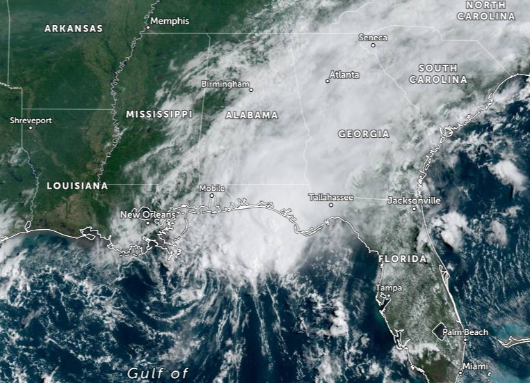
Marco Bringing Heavy Rains and Gusty Winds Along Portions of the Northern Gulf Coast
NHC UPDATE SUMMARY OF 10:00 AM CDT INFORMATION
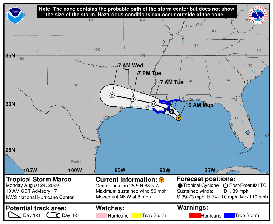
LOCATION…28.5N 88.5W
ABOUT 55 MI…90 KM SE OF THE MOUTH OF THE MISSISSIPPI RIVER
MAXIMUM SUSTAINED WINDS…50 MPH…85 KM/H
PRESENT MOVEMENT…NNW OR 330 DEGREES AT 8 MPH…13 KM/H
MINIMUM CENTRAL PRESSURE…1006 MB…29.71 INCHES
WATCHES AND WARNINGS
A Storm Surge Warning is in effect for….
* Morgan City Louisiana to Ocean Springs Mississippi
* Lake Borgne
A Tropical Storm Warning is in effect for…
* Morgan City to the Mississippi/Alabama border
* Lake Pontchartrain, Lake Maurepas, and Metropolitan New Orleans
DISCUSSION AND OUTLOOK
At 1000 AM CDT (1500 UTC), the center of Tropical Storm Marco was located near latitude 28.5 North, longitude 88.5 West. Marco is moving toward the north-northwest near 8 mph (13 km/h). A turn to the west-northwest is expected to occur by Tuesday, and this motion should continue until the system dissipates in a couple of days.
Maximum sustained winds are near 50 mph (85 km/h) with higher gusts. Steady weakening is forecast, and Marco is expected to weaken to a tropical depression tonight, and degenerate to a remnant low on Tuesday.
Tropical-storm-force winds extend outward up to 105 miles (165 km) from the center.
The estimated minimum central pressure is 1006 MB (29.71 inches).
HAZARDS AFFECTING LAND
STORM SURGE: The combination of a dangerous storm surge and the tide will cause normally dry areas near the coast to be flooded by rising waters moving inland from the shoreline. The water could reach the following heights above ground somewhere in the indicated areas if the peak surge occurs at the time of high tide…
Morgan City LA to Ocean Springs MS, including Lake Borgne…2-4 ft
The deepest water will occur along the immediate coast in areas of onshore winds, where the surge will be accompanied by large and dangerous waves. Surge-related flooding depends on the relative timing of the surge and the tidal cycle, and can vary greatly over short distances. For information specific to your area, please see products issued by your local National Weather Service forecast office.
WIND: Tropical storm conditions are expected to start by this afternoon in portions of the warning area.
RAINFALL: Marco is expected to produce total rainfall accumulations of 3 to 6 inches with isolated maximum amounts of 10 inches across portions of the northeast and north-central Gulf coast through Tuesday. This rainfall may result in areas of flash, urban and small stream flooding along the same area.
SURF: Swells generated by Marco are likely to affect portions of the northern Gulf Coast for the next couple of days. These swells are likely to cause life-threatening surf and rip current conditions. Please consult products from your local weather office.
TORNADOES: A couple of tornadoes are possible today into tonight across the Florida Panhandle, southern Georgia, southern Alabama, and southern Mississippi.
Category: ALL POSTS, Severe Weather, Tropical
About the Author (Author Profile)
Scott Martin is an operational meteorologist, professional graphic artist, musician, husband, and father. Not only is Scott a member of the National Weather Association, but he is also the Central Alabama Chapter of the NWA president. Scott is also the co-founder of Racecast Weather, which provides forecasts for many racing series across the USA. He also supplies forecasts for the BassMaster Elite Series events including the BassMaster Classic.Subscribe
If you enjoyed this article, subscribe to receive more just like it.


