Center of Laura Passing the Isle of Youth; Hurricane Watches Issued for Portions of the Gulf Coast
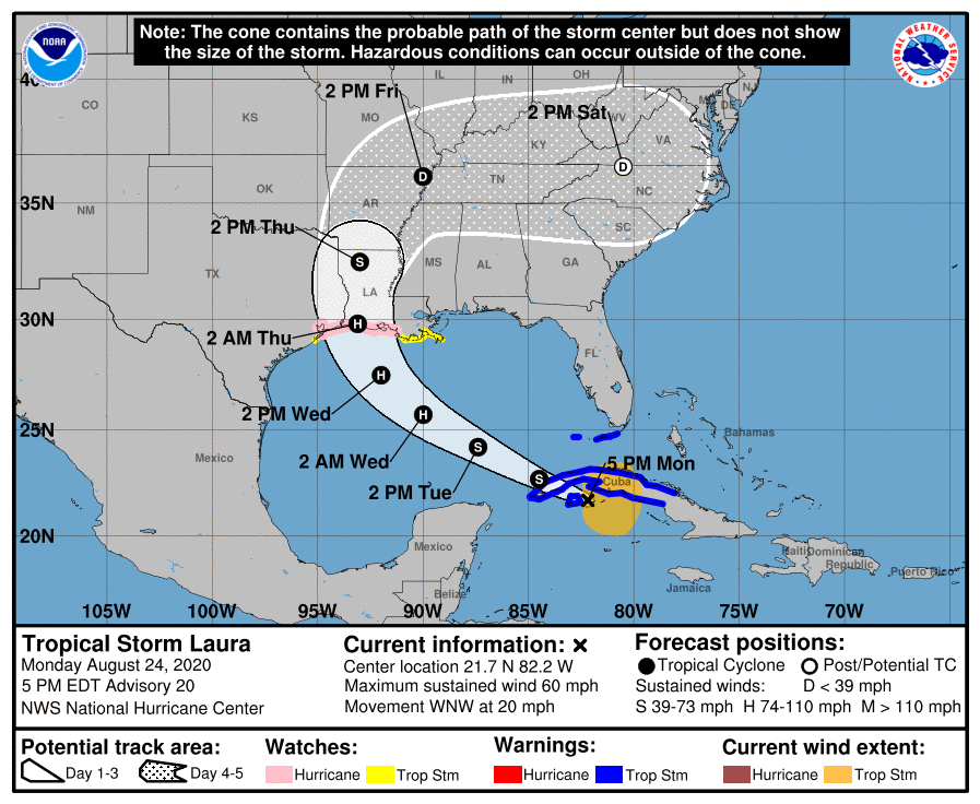
NHC UPDATE SUMMARY OF 4:00 PM CDT INFORMATION
LOCATION: 40 miles east of the Isle of Youth
MAXIMUM WINDS: 60 mph
MOVEMENT: west-northwest at 20 MPH
MINIMUM PRESSURE: 1001 MB or 29.56 in
WATCHES AND WARNINGS
A Storm Surge Watch is in effect for…
* San Luis Pass Texas to Ocean Springs Mississippi
* Lake Pontchartrain, Lake Maurepas, and Lake Borgne
A Hurricane Watch is in effect for…
* Port Bolivar Texas to west of Morgan City Louisiana
A Tropical Storm Warning is in effect for…
* Cuban provinces of Ciego De Avila, Sancti Spiritus, Villa Clara, Cienfuegos, Matanzas, Mayabeque, La Habana, Artemisa, Pinar del Rio, and the Isle of Youth
* The Florida Keys from Craig Key to Key West
* Dry Tortugas
A Tropical Storm Watch is in effect for…
* South of Port Bolivar to San Luis Pass Texas
* Morgan City Louisiana to the Mouth of the Mississippi River
DISCUSSION AND OUTLOOK
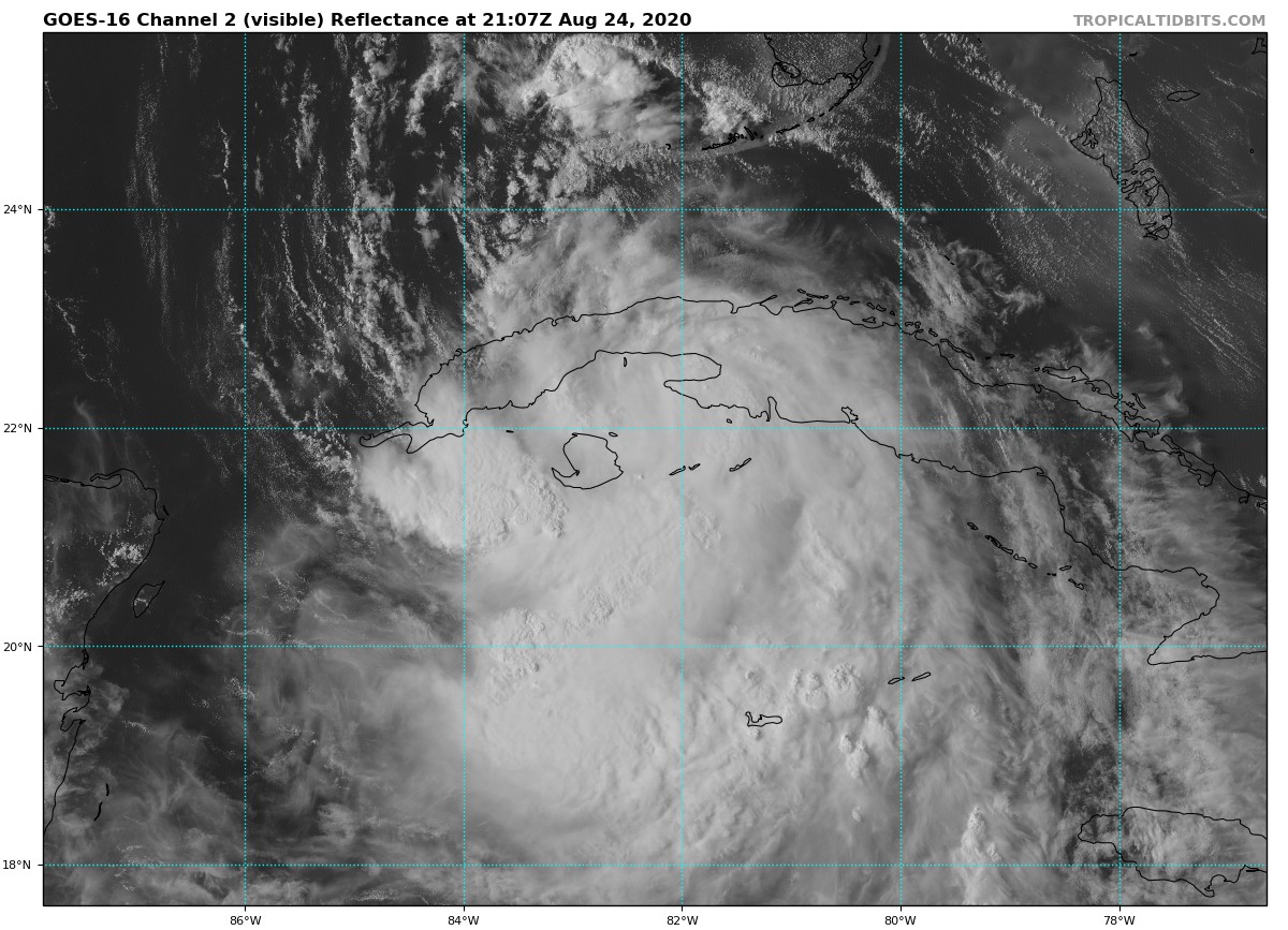
At 500 PM EDT (2100 UTC), the center of Tropical Storm Laura was located near latitude 21.7 North, longitude 82.2 West. Laura is moving toward the west-northwest near 20 mph (31 km/h), and this general motion with some decrease in forward speed is expected over the next day or so. A turn toward the northwest is forecast by Wednesday, and a northwestward to north-northwestward motion should continue through Wednesday night. On the forecast track, the center of Laura will cross western Cuba this evening and move into the southeastern Gulf of Mexico overnight. Laura is then forecast to move over the central and northwestern Gulf of Mexico Tuesday night and Wednesday, and approach the northwestern coast of the Gulf of Mexico Wednesday night.
Maximum sustained winds are near 60 mph (95 km/h) with higher gusts. Strengthening is expected when the storm moves over the Gulf of Mexico, and Laura is forecast to become a hurricane by late Tuesday. Additional strengthening is forecast on Wednesday.
Tropical-storm-force winds extend outward up to 175 miles (280 km) primarily to the northeast and east of the center.
The estimated minimum central pressure is 1001 MB (29.56 inches).
HAZARDS AFFECTING LAND
STORM SURGE: The combination of a dangerous storm surge and the tide will cause normally dry areas near the coast to be flooded by rising waters moving inland from the shoreline. The water could reach the following heights above ground somewhere in the indicated areas if the peak surge occurs at the time of high tide…
High Island TX to Morgan City LA including Sabine Lake, Calcasieu Lake, and Vermilion Bay…7-11 ft
Port Bolivar TX to High Island TX…4-6 ft
Morgan City LA to Mouth of the Mississippi River…4-6 ft
The mouth of the Mississippi River to Ocean Springs MS including Lake Borgne…3-5 ft
San Luis Pass TX to Port Bolivar TX…2-4 ft
Galveston Bay…2-4 ft
Lake Pontchartrain and Lake Maurepas…2-4 ft
The deepest water will occur along the immediate coast near and to the right of the landfall location, where the surge will be accompanied by large and destructive waves. Surge-related flooding depends on the relative timing of the surge and the tidal cycle and can vary greatly over short distances. For information specific to your area, please see products issued by your local National Weather Service forecast office.
RAINFALL: Laura is expected to produce the following storm total rainfall accumulations into tonight:
Western Jamaica, Western Cuba, and the Cayman Islands: 4 to 6 inches, with maximum amounts of 10 inches. Across the Greater Antilles, this heavy rainfall could lead to life-threatening flash and urban flooding, and the potential for mudslides.
From Wednesday afternoon into Saturday, Laura is expected to produce rainfall of 4 to 8 inches, with isolated maximum amounts of 12 inches across portions of the west-central U.S. Gulf Coast near the Texas and Louisiana border north into portions of the Lower Mississippi Valley. This rainfall could cause widespread flash and urban flooding, small streams to overflow their banks, and minor to isolated moderate river flooding.
WIND: Tropical storm conditions are expected to spread westward within the warning area in western Cuba through this evening. Tropical storm conditions are also expected within the warning area in the middle and lower Florida Keys and the Dry Tortugas tonight.
Hurricane conditions are possible in the hurricane watch area along the Gulf Coast by late Wednesday, with tropical storm conditions possible by Wednesday afternoon.
SURF: Swells generated by Laura are affecting portions of Cuba, the central Bahamas, and the Florida Keys. Swells are expected to spread northward along portions of the west coast of Florida peninsula and the coast of the Florida panhandle on Tuesday and Tuesday night and reach the northern and northwest Gulf coast by Wednesday. These swells are likely to cause life-threatening surf and rip current conditions. Please consult products from your local weather office.
TORNADOES: An isolated tornado is possible through tonight across the Florida Keys.
Category: ALL POSTS, Severe Weather, Tropical
About the Author (Author Profile)
Scott Martin is an operational meteorologist, professional graphic artist, musician, husband, and father. Not only is Scott a member of the National Weather Association, but he is also the Central Alabama Chapter of the NWA president. Scott is also the co-founder of Racecast Weather, which provides forecasts for many racing series across the USA. He also supplies forecasts for the BassMaster Elite Series events including the BassMaster Classic.Subscribe
If you enjoyed this article, subscribe to receive more just like it.


