Tropical Showers Across a Good Portion of Central Alabama at Midday; Eyes Focusing on Hurricane Laura
WHAT’S HAPPENING OUTSIDE AT MIDDAY
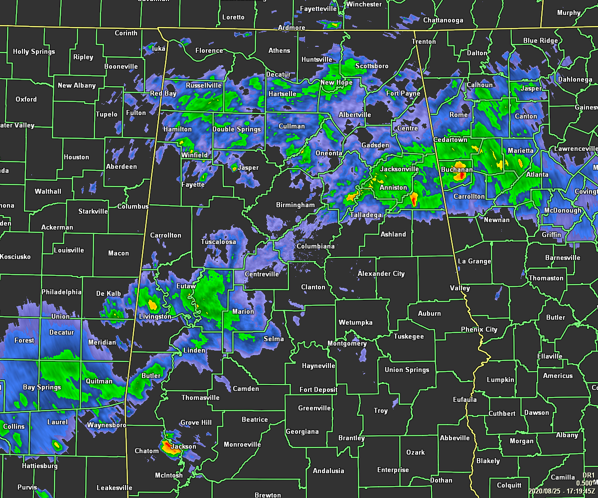
Radar check at 12:20 pm – Tropical moisture from the remnants of Marco continues to push slowly northward through Central Alabama with some of the heavier showers and storms causing some flash flooding issues out there. Portions of Sumter County are under a Flash Flood Warning until 2:00 pm this afternoon due to continuous heavy rain. The southern-most rain band nearly follows I-20 across the eastern half of the state and bends southwestward similar to the path that I-20/59 takes in the western half. Showers also cover a good portion of the northern parts of Central Alabama and up into much of North Alabama.
Temperatures across the area were ranging from as low as 73 degrees in Haleyville and Talladega due to rain-cooled air, to as warm as 84 degrees in Troy with cloudy and dry conditions. Birmingham was cloudy and at 77 degrees.
WEATHER FOR THE REST OF YOUR TUESDAY
We’ll continue to have widespread rain and a few embedded thunderstorms across much of Central Alabama through the rest of the afternoon and into the early evening hours. Some heavier rains may cause some localized flooding issues. The threat of strong to severe storms is very low, but don’t be surprised if we do have one or two that we’ll have to talk about. Skies will be mainly cloudy when it is not raining in your location. Highs will be in the upper 70s to the lower 90s across the area. Those hotter temperatures will be in the southeastern parts of the area where there will be less rain coverage and a little more sunshine.
A few scattered showers and storms may continue into the evening and late-night hours, with one or two lingering into the overnight hours especially over the north and western parts of the area. Overnight lows will be in the lower to mid-70s.
LATEST HAZARDOUS WEATHER OUTLOOK FROM NWS BIRMINGHAM
With the latest forecast track of Hurricane Laura, those outer rainbands may bring tropical rain and some stronger storms to the area on Friday as the center looks to pass by well to our north. Here is the latest from NWS Birmingham concerning that situation.
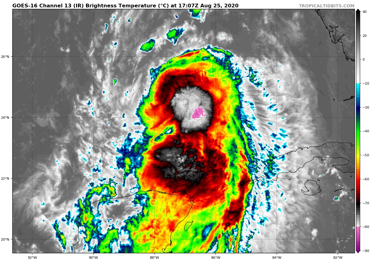
Tropical Storm Laura is forecast to strengthen to a hurricane before making landfall along the southeast Texas or southwest Louisiana coast Wednesday night. The more widespread strong winds and heavy rainfall will stay west of Central Alabama. However, the remnants of Laura could generate a couple severe storms with damaging winds or a brief tornado as well as localized heavy rainfall mainly across far northwestern and northern portions of Central Alabama Friday and Friday night.
SPEAKING OF HURRICANE LAURA
As of the 10:00 am update from the NHC:
LOCATION: 585 miles southeast of Lake Charles, Louisiana
MAXIMUM WINDS: 75 mph
MOVEMENT: west-northwest at 16 MPH
MINIMUM PRESSURE: 990 MB or 29.24 in
A turn toward the northwest is forecast by Wednesday, and a northwestward to north-northwestward motion should continue through Wednesday night. On the forecast track, the center of Laura will move across the southeastern Gulf of Mexico today. Laura is then forecast to move over the central and northwestern Gulf of Mexico tonight and Wednesday, approach the Upper Texas and Southwest Louisiana coasts on Wednesday night and move inland near those areas on Thursday. Significant strengthening is forecast during the next 36 hours, and Laura is expected to be a major hurricane at landfall.
From Wednesday night into Saturday, Laura is expected to produce rainfall of 4 to 8 inches, with isolated maximum amounts of 12 inches across portions of the west-central U.S. Gulf Coast from western Louisiana into east Texas, and northward into portions of the lower to middle Mississippi Valley, lower Ohio Valley, and Tennessee Valley. This rainfall will cause widespread flash and urban flooding, small streams to overflow their banks, and minor to isolated moderate river flooding.
Hurricane conditions are expected in the hurricane warning area Wednesday night and Thursday. Tropical Storm conditions are expected to reach the coast in the hurricane warning area late Wednesday or Wednesday night and are expected in the tropical storm warning area Wednesday night and Thursday.
Swells generated by Laura are affecting portions of Cuba, the central Bahamas, and the Florida Keys. Swells are expected to spread northward along portions of the west coast of Florida peninsula and the coast of the Florida panhandle later today and tonight, and reach the northern and northwest Gulf coast by Wednesday. These swells are likely to cause life-threatening surf and rip current conditions.
The combination of a dangerous storm surge and the tide will cause normally dry areas near the coast to be flooded by rising waters moving inland from the shoreline. The water could reach the following heights above ground somewhere in the indicated areas if the peak surge occurs at the time of high tide…
Sea Rim State Park TX to Intracoastal City LA including Sabine Lake and Calcasieu Lake: 9-13 ft
Intracoastal City to Morgan City including Vermilion Bay: 7-11 ft
Port Bolivar TX to Sea Rim State Park: 6-9 ft
Morgan City LA to Mouth of the Mississippi River: 4-6 ft
San Luis Pass TX to Port Bolivar: 3-5 ft
Galveston Bay: 3-5 ft
Freeport TX to San Luis Pass: 2-4 ft
The mouth of the Mississippi River to Ocean Springs MS including Lake Borgne: 3-5 ft
Lake Pontchartrain and Lake Maurepas: 2-4 ft
Category: Alabama's Weather, ALL POSTS, Severe Weather, Tropical
About the Author (Author Profile)
Scott Martin is an operational meteorologist, professional graphic artist, musician, husband, and father. Not only is Scott a member of the National Weather Association, but he is also the Central Alabama Chapter of the NWA president. Scott is also the co-founder of Racecast Weather, which provides forecasts for many racing series across the USA. He also supplies forecasts for the BassMaster Elite Series events including the BassMaster Classic.Subscribe
If you enjoyed this article, subscribe to receive more just like it.


