Laura Continues to Strengthen, Now Approaching Category 2 Strength
NHC UPDATE SUMMARY OF 10:00 PM CDT INFORMATION
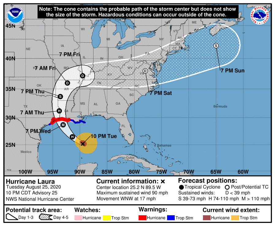
LOCATION: 430 miles southeast of Galveston, Texas
MAXIMUM WINDS: 90 mph
MOVEMENT: west-northwest at 17 MPH
MINIMUM PRESSURE: 978 MB or 28.88 in
WATCHES AND WARNINGS
A Storm Surge Warning is in effect for…
* San Luis Pass Texas to the Mouth of the Mississippi River
A Hurricane Warning is in effect for…
* San Luis Pass Texas to Intracoastal City Louisiana
A Tropical Storm Warning is in effect for…
* Sargent Texas to San Luis Pass
* East of Intracoastal City Louisiana to the Mouth of the Mississippi River
A Storm Surge Watch is in effect for…
* Freeport Texas to San Luis Pass
* Mouth of the Mississippi River to Ocean Springs Mississippi
* Lake Pontchartrain, Lake Maurepas, and Lake Borgne
A Hurricane Watch is in effect for…
* East of Intracoastal City to the west of Morgan City Louisiana
DISCUSSION AND OUTLOOK
At 1000 PM CDT (0300 UTC), the center of Hurricane Laura was located near latitude 25.2 North, longitude 89.5 West. Laura is moving toward the west-northwest near 17 mph (28 km/h), and this general motion should continue overnight. A turn toward the northwest is forecast on Wednesday, and a northwestward to north-northwestward motion should continue through Wednesday night. On the forecast track, the center of Laura will move across the northwestern Gulf of Mexico on Wednesday. The hurricane should approach the Upper Texas and southwest Louisiana coasts on Wednesday evening and move inland near those areas Wednesday night or Thursday morning.
Maximum sustained winds have increased to near 90 mph (150 km/h) with higher gusts. Significant strengthening is forecast during the next 24 hours, and Laura is expected to be a major hurricane at landfall. Rapid weakening is expected after Laura makes landfall.
Hurricane-force winds extend outward up to 45 miles (75 km) from the center and tropical-storm-force winds extend outward up to 175 miles (280 km). NOAA buoy 42001 in the central Gulf of Mexico recently reported a sustained wind of 45 mph (72 km/h) and a gust to 54 mph (86 km/h).
The minimum central pressure estimated from Hurricane Hunter observations is 978 MB (28.88 inches).
HAZARDS AFFECTING LAND
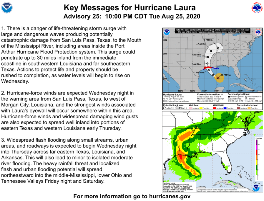
STORM SURGE: The combination of a dangerous storm surge and the tide will cause normally dry areas near the coast to be flooded by rising waters moving inland from the shoreline. The water could reach the following heights above ground somewhere in the indicated areas if the peak surge occurs at the time of high tide…
• Sea Rim State Park TX to Intracoastal City LA including Sabine Lake and Calcasieu Lake…9-14 ft
• Intracoastal City to Morgan City including Vermilion Bay…7-11 ft
• Port Bolivar TX to Sea Rim State Park…6-9 ft
• Morgan City LA to Mouth of the Mississippi River…4-6 ft
• San Luis Pass TX to Port Bolivar…3-5 ft
• Galveston Bay…3-5 ft
• Freeport TX to San Luis Pass…2-4 ft
• The Mouth of the Mississippi River to Ocean Springs MS including Lake Borgne…2-4 ft
• Lake Pontchartrain and Lake Maurepas…2-4 ft
The deepest water will occur along the immediate coast near and to the right of the landfall location, where the surge will be accompanied by large and destructive waves. This storm surge could penetrate up to 30 miles inland from the immediate coastline in southwestern Louisiana and far southeastern Texas.
Surge-related flooding depends on the relative timing of the surge and the tidal cycle, and can vary greatly over short distances.
RAINFALL: From Wednesday afternoon through Friday, Laura is expected to produce rainfall totals of 5 to 10 inches, with isolated maximum amounts of 15 inches across portions of the northwestern Gulf Coast from western Louisiana to far eastern Texas, and northward into much of Arkansas. Over the lower to middle Mississippi Valley from central Louisiana into western Tennessee and Kentucky and southeastern Missouri, 2 to 4 inches of rainfall with isolated totals of 6 inches are expected. This rainfall will cause widespread flash and urban flooding, small streams to overflow their banks, and minor to isolated moderate river flooding.
By late Friday into Saturday, portions of the Tennessee and Ohio Valley could see 2 to 4 inches with locally higher amounts as tropical moisture from Laura moves through the region. This rainfall could lead to localized flash and urban flooding along small streams.
WIND: Hurricane conditions are expected in the hurricane warning area Wednesday night and Thursday. Tropical storm conditions are expected to reach the coast in the hurricane warning area late Wednesday or Wednesday night and are expected in the tropical storm warning area Wednesday night and Thursday.
Hurricane-force winds and damaging wind gusts are also expected to spread well inland into portions of eastern Texas and western Louisiana early Thursday.
TORNADOES: A few tornadoes are expected Wednesday evening into Wednesday night over Louisiana, far southeast Texas, and southwestern Mississippi. The risk for a few tornadoes should continue into Thursday across Louisiana, Arkansas, and western Mississippi.
SURF: Swells produced by Laura are affecting the U.S. Gulf coast from the west coast of Florida to Louisiana and are expected to reach the coast of Texas and northeastern Mexico overnight and on Wednesday. These swells are likely to cause life-threatening surf and rip current conditions.
Category: ALL POSTS, Severe Weather, Tropical
About the Author (Author Profile)
Scott Martin is an operational meteorologist, professional graphic artist, musician, husband, and father. Not only is Scott a member of the National Weather Association, but he is also the Central Alabama Chapter of the NWA president. Scott is also the co-founder of Racecast Weather, which provides forecasts for many racing series across the USA. He also supplies forecasts for the BassMaster Elite Series events including the BassMaster Classic.Subscribe
If you enjoyed this article, subscribe to receive more just like it.


