Little Time Remains to Protect Life and Property as Now Category 4 Hurricane Laura Approaches
NHC UPDATE SUMMARY OF 1:00 PM CDT INFORMATION
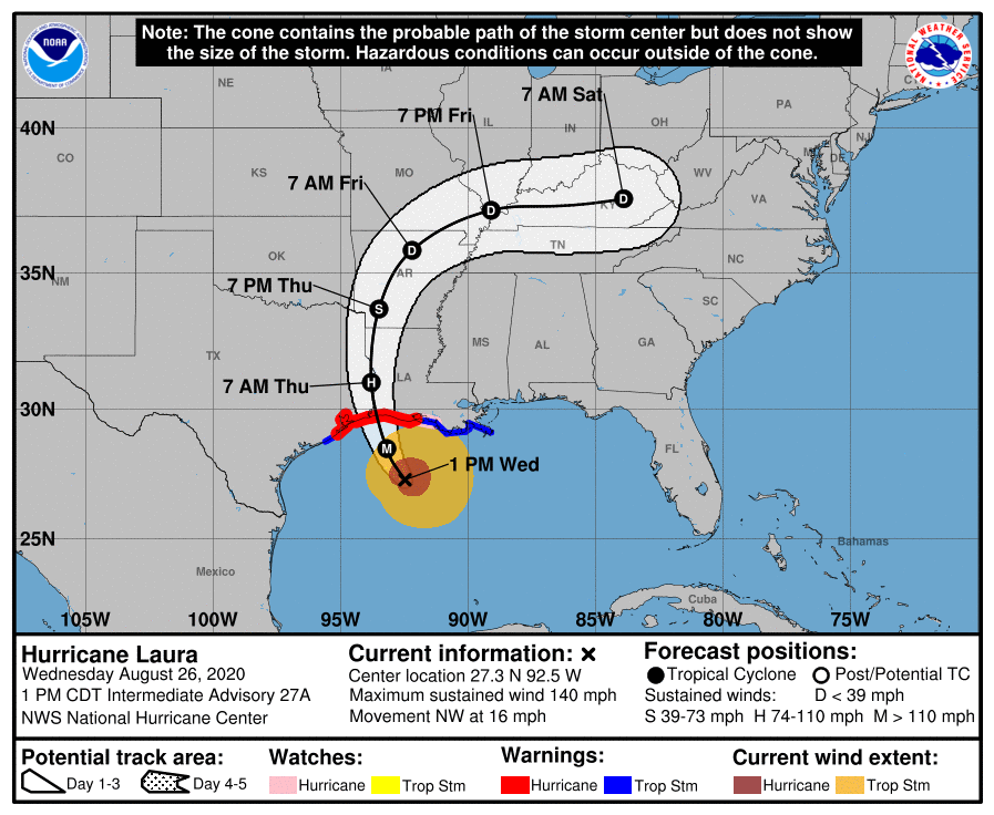
LOCATION: 200 miles south-southeast of Lake Charles, Louisiana
MAXIMUM WINDS: 140 mph
MOVEMENT: northwest at 16 MPH
MINIMUM PRESSURE: 952 MB or 28.11 in
WATCHES AND WARNINGS
A Storm Surge Warning is in effect for…
* Freeport Texas to the Mouth of the Mississippi River
A Hurricane Warning is in effect for…
* San Luis Pass Texas to Intracoastal City Louisiana
A Tropical Storm Warning is in effect for…
* Sargent Texas to San Luis Pass
* East of Intracoastal City Louisiana to the Mouth of the Mississippi River
A Storm Surge Watch is in effect for…
* Mouth of the Mississippi River to Ocean Springs Mississippi
* Lake Pontchartrain, Lake Maurepas, and Lake Borgne
A Hurricane Watch is in effect for…
* East of Intracoastal City to the west of Morgan City Louisiana
DISCUSSION AND OUTLOOK
At 100 PM CDT (1800 UTC), the eye of Hurricane Laura was located near latitude 27.3 North, longitude 92.5 West. Laura is moving toward the northwest near 16 mph (26 km/h). A gradual turn toward the north-northwest and north is expected later today and tonight. On the forecast track, Laura will approach the Upper Texas and southwest Louisiana coasts this evening and move inland within that area tonight. The center of Laura is forecast to move over northwestern Louisiana tomorrow, across Arkansas Thursday night, and over the mid-Mississippi Valley on Friday.
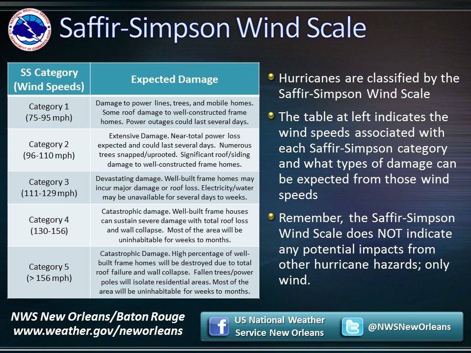
Reports from an Air Force Reserve Hurricane Hunter aircraft indicate that maximum sustained winds have increased to near 140 mph (220 km/h) with higher gusts. Laura is an extremely dangerous category 4 hurricane on the Saffir-Simpson Hurricane Wind Scale. Some additional strengthening is possible this afternoon, and Laura is forecast to remain a category 4 hurricane through landfall tonight. Rapid weakening is expected after Laura makes over land.
Hurricane-force winds extend outward up to 70 miles (110 km) from the center and tropical-storm-force winds extend outward up to 175 miles (280 km). Tropical-storm-force winds have reached the coast of Louisiana and an observing site at Eugene Island recently measured sustained winds of 39 mph (63 km/h) and a gust to 64 mph (104 km/h).
The latest minimum central pressure estimated from reconnaissance aircraft data is 952 MB (28.11 inches).
HAZARDS AFFECTING LAND
Storm surge and tropical-storm-force winds will arrive within the warning areas well in advance of Laura’s center. All preparations to protect life and property should be rushed to completion in the next few hours.
STORM SURGE: The combination of a dangerous storm surge and the tide will cause normally dry areas near the coast to be flooded by rising waters moving inland from the shoreline. The water could reach the following heights above ground somewhere in the indicated areas if the peak surge occurs at the time of high tide…
Johnson Bayou LA to Rockefeller Wildlife Refuge including Calcasieu Lake…15-20 ft
Sea Rim State Park TX to Johnson Bayou LA including Sabine Lake…10-15 ft
Rockefeller Wildlife Refuge to Intracoastal City LA…10-15 ft
Intracoastal City LA to Morgan City including Vermilion Bay…8-12 ft
Port Bolivar TX to Sea Rim State Park…6-9 ft
Morgan City LA to Mouth of the Mississippi River…4-7 ft
Freeport TX to Port Bolivar including Galveston Bay…2-4 ft
The mouth of the Mississippi River to Ocean Springs MS including Lake Borgne…2-4 ft
Lake Pontchartrain and Lake Maurepas…2-4 ft
The deepest water will occur along the immediate coast near and to the right of the landfall location, where the surge will be accompanied by large and destructive waves.
Unsurvivable storm surge with large and destructive waves will cause catastrophic damage from Sea Rim State Park, Texas, to Intracoastal City, Louisiana, including Calcasieu and Sabine Lakes. This storm surge could penetrate up to 30 miles inland from the immediate coastline in southwestern Louisiana and far southeastern Texas.
Surge-related flooding depends on the relative timing of the surge and the tidal cycle and can vary greatly over short distances. For information specific to your area, please see products issued by your local National Weather Service forecast office.
WIND: Hurricane conditions are expected in the hurricane warning area tonight and Thursday, with catastrophic wind damage expected where Laura’s eyewall makes landfall tonight. Tropical storm conditions are moving onshore of the coast of Louisiana within the tropical storm warning area and are expected to reach the coast in the hurricane warning area later this afternoon or evening.
Hurricane-force winds and damaging wind gusts are also expected to spread well inland into portions of eastern Texas and western Louisiana early Thursday.
RAINFALL: From this afternoon through Friday, Laura is expected to produce rainfall totals of 5 to 10 inches, with isolated maximum amounts of 15 inches across portions of the northwestern Gulf Coast from western Louisiana to far eastern Texas, and northward into much of Arkansas. This rainfall will cause widespread flash and urban flooding, small streams and creeks to overflow their banks, and minor to isolated moderate freshwater river flooding.
By Friday into Saturday, Laura will produce rainfall totals of 2 to 4 inches, with isolated maximum amounts of 6 inches across the mid-Mississippi and portions of the Lower Ohio and Lower Tennessee Valleys. This rainfall may lead to localized flash and urban flooding and rapid rises on small streams.
TORNADOES: A few tornadoes are expected this afternoon through tonight over Louisiana, far southeast Texas, and southwestern Mississippi. The risk for a few tornadoes should continue into Thursday across Louisiana, Arkansas, and western Mississippi.
SURF: Swells produced by Laura are affecting the entire U.S. Gulf coast from the west coast of Florida to Texas and northeastern Mexico. These swells are likely to cause life-threatening surf and rip current conditions. Please consult products from your local weather office.
Category: ALL POSTS, Severe Weather, Tropical
About the Author (Author Profile)
Scott Martin is an operational meteorologist, professional graphic artist, musician, husband, and father. Not only is Scott a member of the National Weather Association, but he is also the Central Alabama Chapter of the NWA president. Scott is also the co-founder of Racecast Weather, which provides forecasts for many racing series across the USA. He also supplies forecasts for the BassMaster Elite Series events including the BassMaster Classic.Subscribe
If you enjoyed this article, subscribe to receive more just like it.


