Wind and Water Levels Increasing as Extremely Dangerous Hurricane Laura Takes Aim at the Northwest Gulf Coast
NHC UPDATE SUMMARY OF 4:00 PM CDT INFORMATION
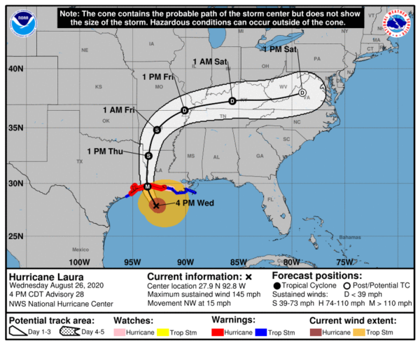
LOCATION: 155 miles south of Lake Charles, Louisiana
MAXIMUM WINDS: 145 mph
MOVEMENT: northwest at 15 MPH
MINIMUM PRESSURE: 947 MB or 27.97 in
WATCHES AND WARNINGS
A Storm Surge Warning is in effect for…
* Freeport Texas to the Mouth of the Mississippi River
A Hurricane Warning is in effect for…
* San Luis Pass Texas to Intracoastal City Louisiana
A Tropical Storm Warning is in effect for…
* Sargent Texas to San Luis Pass
* East of Intracoastal City Louisiana to the Mouth of the Mississippi River
A Hurricane Watch is in effect for…
* East of Intracoastal City to the west of Morgan City Louisiana
DISCUSSION AND OUTLOOK
At 400 PM CDT (2100 UTC), the eye of Hurricane Laura was located near latitude 27.9 North, longitude 92.8 West. Laura is moving toward the northwest near 15 mph (24 km/h). A turn toward the north-northwest and north is expected tonight, and a northward motion should continue on Thursday. A northeastward to east-northeastward motion is expected Thursday night and Friday. On the forecast track, Laura will approach the Upper Texas and southwest Louisiana coasts this evening and move inland within that area tonight. The center of Laura is forecast to move over northwestern Louisiana tomorrow, across Arkansas Thursday night, and over the mid-Mississippi Valley on Friday.
Reports from an Air Force Reserve hurricane hunter aircraft indicate that the maximum sustained winds have increased to near 145 mph (230 km/h) with higher gusts. Laura is an extremely dangerous category 4 hurricane on the Saffir-Simpson Hurricane Wind Scale. Some additional strengthening is possible this evening before Laura reaches the northwest Gulf coast overnight. Rapid weakening is expected after Laura moves inland.
Hurricane-force winds extend outward up to 60 miles (95 km) from the center and tropical-storm-force winds extend outward up to 205 miles (335 km).
The latest minimum central pressure reported by an Air Force
Reserve reconnaissance aircraft is 947 MB (27.97 inches).
HAZARDS AFFECTING LAND
Storm surge and tropical-storm-force winds will arrive within the
warning areas well in advance of Laura’s center. All preparations
to protect life and property should be rushed to completion in the
next few hours.
STORM SURGE: The combination of a dangerous storm surge and the tide will cause normally dry areas near the coast to be flooded by rising waters moving inland from the shoreline. The water could reach the following heights above ground somewhere in the indicated areas if the peak surge occurs at the time of high tide…
Johnson Bayou LA to Rockefeller Wildlife Refuge including Calcasieu Lake…15-20 ft
Sea Rim State Park TX to Johnson Bayou LA including Sabine Lake…10-15 ft
Rockefeller Wildlife Refuge to Intracoastal City LA…10-15 ft
Intracoastal City LA to Morgan City including Vermilion Bay…8-12 ft
Port Bolivar TX to Sea Rim State Park…6-9 ft
Morgan City LA to Mouth of the Mississippi River…4-7 ft
Freeport TX to Port Bolivar including Galveston Bay…2-4 ft
Mouth of the Mississippi River to Ocean Springs MS including Lake Borgne…1-3 ft
Lake Pontchartrain and Lake Maurepas…1-3 ft
The deepest water will occur along the immediate coast near and to the right of the landfall location, where the surge will be accompanied by large and destructive waves.
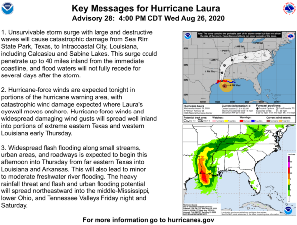
Unsurvivable storm surge with large and destructive waves will cause catastrophic damage from Sea Rim State Park, Texas, to Intracoastal City, Louisiana, including Calcasieu and Sabine Lakes. This surge could penetrate up to 40 miles inland from the immediate coastline, and floodwaters will not fully recede for several days after the storm.
Surge-related flooding depends on the relative timing of the surge and the tidal cycle and can vary greatly over short distances.
WIND: Hurricane conditions are expected in the hurricane warning area tonight and Thursday, with catastrophic wind damage expected where Laura’s eyewall moves onshore tonight. Tropical storm conditions are moving onshore along the coast of Louisiana within the tropical storm warning area and are expected to spread northwestward within the warning areas this evening.
Hurricane-force winds and damaging wind gusts are also expected to spread well inland into portions of eastern Texas and western Louisiana early Thursday.
RAINFALL: From this afternoon through Friday, Laura is expected to produce the following rainfall totals:
Across the northwestern Gulf Coast from far southwest Louisiana and the Golden Triangle of Southeast Texas: 8 to 12 inches with isolated totals of 18 inches.
Across central and the rest of western Louisiana into far eastern Texas: 5 to 10 inches with isolated totals of 15 inches.
Across much of Arkansas: 3 to 7 inches with isolated totals of 10 inches.
This rainfall will cause widespread flash and urban flooding, small streams and creeks to overflow their banks, and minor to moderate freshwater river flooding.
By Friday into Saturday, Laura is expected to produce the following rainfall totals:
Across the mid-Mississippi and portions of the Tennessee Valley, Lower Ohio Valley, and central Appalachians: 2 to 4 inches with isolated maximum amounts of 6 inches.
This rainfall may lead to flash and urban flooding and rapid rises on small streams.
Across the Mid-Atlantic Region: 1 to 3 inches.
TORNADOES: Several tornadoes are expected late this afternoon through tonight over Louisiana, far southeast Texas, and southwestern Mississippi. The risk for a few tornadoes will continue into Thursday across Louisiana, Arkansas, and western Mississippi.
SURF: Swells produced by Laura are affecting the U.S. Gulf coast from the west coast of Florida to Texas and northeastern Mexico. These swells are likely to cause life-threatening surf and rip current conditions.
Category: ALL POSTS, Severe Weather, Tropical


