2:00 am Laura Update; A Few Raw Reports from NWS Chat for the Lake Charles, Louisiana, Region
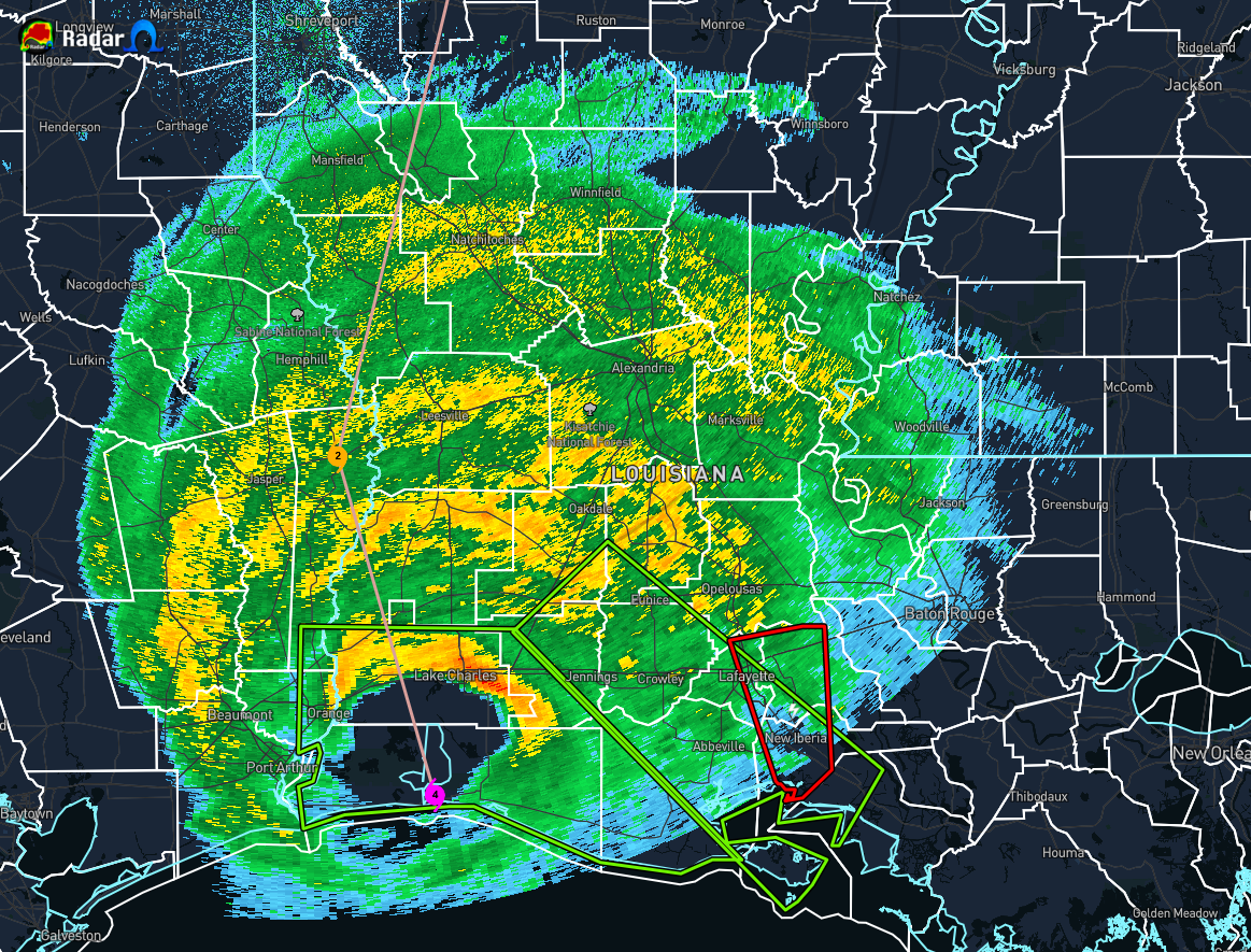
…EYEWALL OF LAURA PUSHING INLAND ACROSS SOUTHWESTERN LOUISIANA…
…CATASTROPHIC STORM SURGE, EXTREME WINDS, AND FLASH FLOODING ONGOING…
The eyewall of Laura will continue to move inland across southwestern Louisiana during the next several hours. TAKE COVER NOW! Treat these imminent extreme winds as if a tornado was approaching and move immediately to the safe room in your shelter. Take action now to protect your life!
The safest place to be during a major landfalling hurricane is in a reinforced interior room away from windows. Get under a table or other piece of sturdy furniture. Use mattresses, blankets, or pillows to cover your head and body. Remain in place through the passage of these life-threatening conditions.
A National Ocean Service tide station at Calcasieu Pass, Louisiana observed a water level rise of 9.19 ft Mean Higher High Water at 100 CDT.
The Lake Charles, Louisiana airport recently reported a sustained wind of 85 mph (137 km/h) with a gust to 128 mph (206 km/h).
A University of Florida observing tower near Lake Charles recently reported a sustained wind of 86 mph (138 km/h) with a gust to 112 mph (180 km/h)
A Texas Coastal Ocean Observing Network site at Sabine Pass on the Texas/Louisiana border recently reported sustained winds of 74 mph (119 km/h) with a gust to 90 mph (145 km/h).
SUMMARY OF 200 AM CDT…0700 UTC…INFORMATION
———————————————–
LOCATION…30.0N 93.3W
ABOUT 10 MI…15 KM SW OF LAKE CHARLES LOUISIANA
ABOUT 40 MI…65 KM E OF PORT ARTHUR TEXAS
MAXIMUM SUSTAINED WINDS…140 MPH…225 KM/H
PRESENT MOVEMENT…N OR 350 DEGREES AT 15 MPH…24 KM/H
MINIMUM CENTRAL PRESSURE…941 MB…27.79 INCHES
RAW REPORT DATA FROM LAKE CHARLES NWS CHAT
Lake Charles [Calcasieu Co, LA] PUBLIC reports HURRICANE at 1:32 AM CDT — WINDOWS BLOWN OUT OF A FURNITURE STORE IN LAKE CHARLES.
BEAUMONT/PORT ARTHU,TX (BPT) ASOS reports gust of 63 knots (72.5 mph) from NNW @ 0639Z
KBPT 270639Z AUTO 33042G63KT 5SM -RA BR FEW016 BKN085 OVC110 24/24 A2919 RMK AO2 PK WND 33063/0638 P0009 T02440239
South Marsh 268,LA (SCF) ASOS reports gust of 54 knots (62.1 mph) from SSE @ 0625Z
KSCF 270625Z AUTO 15046G54KT 2 1/2SM HZ SCT020 BKN025 OVC065 29/26 A2963 RMK A01
Jennings, LA (3R7) ASOS reports gust of 51 knots (58.7 mph) from ESE @ 0635Z
K3R7 270635Z AUTO 12041G51KT 3SM +RA BKN011 BKN016 OVC022 25/25 A2936 RMK AO2 LTG DSNT SE P0012 T02510251
3 SW Cameron [Cameron Co, LA] PUBLIC reports STORM SURGE at 1:00 AM CDT — WATER LEVELS OF 9.19 FT MHHW OBSERVED AT CALCASIEU PASS.
Sulphur [Calcasieu Co, LA] STORM CHASER reports HURRICANE at 1:23 AM CDT — POWER FLASHES OBSERVED IN SULPHUR.
3 ENE Lake Charles [Calcasieu Co, LA] PUBLIC reports HURRICANE at 1:15 AM CDT — WIND GUST TO 83 MPH MEASURED AT CHENAULT AIRPARK.
6 SSW Lake Charles [Calcasieu Co, LA] OFFICIAL NWS OBS reports HURRICANE at 1:18 AM CDT — 128 MPH WIND GUST AND SUSTAINED WINDS OF 85 MPH MEASURED AT LAKE CHARLES REGIONAL AIRPORT.
Category: ALL POSTS, Severe Weather, Tropical
About the Author (Author Profile)
Scott Martin is an operational meteorologist, professional graphic artist, musician, husband, and father. Not only is Scott a member of the National Weather Association, but he is also the Central Alabama Chapter of the NWA president. Scott is also the co-founder of Racecast Weather, which provides forecasts for many racing series across the USA. He also supplies forecasts for the BassMaster Elite Series events including the BassMaster Classic.Subscribe
If you enjoyed this article, subscribe to receive more just like it.


