Severe Weather Threat Continues for Locations Under Tornado Watch
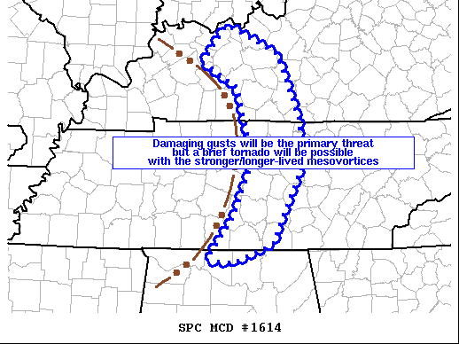
Mesoscale Discussion 1614
SUMMARY…Damaging gusts near bowing segments will be the primary threat but a brief tornado will be possible with the stronger/longer-lived mesovortices.
DISCUSSION…Radar mosaic shows an arcing squall line from parts of western KY into middle TN on the eastern periphery of Laura’s rain shield over the lower OH/TN Valleys. Surface temperatures have warmed into the lower 80s F with dewpoints in the lower to mid-70s. The high precipitable water environment will remain conducive for water-loaded downdrafts in the inflection/bowing segments as the larger-scale squall line moves northeast this afternoon. It is within the inflections within the squall line where there is a conditional risk for a brief tornado.
Category: Alabama's Weather, ALL POSTS, Severe Weather
About the Author (Author Profile)
Scott Martin is an operational meteorologist, professional graphic artist, musician, husband, and father. Not only is Scott a member of the National Weather Association, but he is also the Central Alabama Chapter of the NWA president. Scott is also the co-founder of Racecast Weather, which provides forecasts for many racing series across the USA. He also supplies forecasts for the BassMaster Elite Series events including the BassMaster Classic.Subscribe
If you enjoyed this article, subscribe to receive more just like it.


