Can You Tell We Are Approaching the Peak of the Atlantic Hurricane Season?
As of the latest update on the Tropical Weather Outlook, we have six… count them… six active hot spots in the tropics that the National Hurricane Center is keeping a good watch on. Way too early to know if any of these will make it into the Gulf of Mexico and be a threat to the Alabama Gulf Coast. Here is the latest…
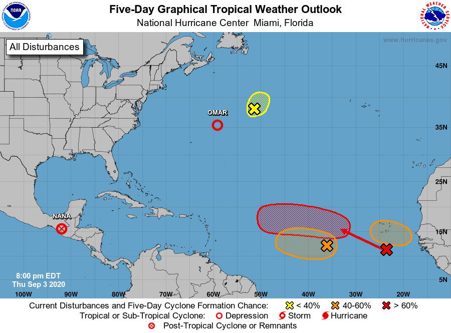
Nana has dissipated into a remnant low near the Guatemala/Mexico border, but those remnants will continue to bring heavy rains to portions of Guatemala, Chipas, and Oaxaca through the end of the day on Friday. No more advisories will be issued for the remnants of Nana as weakening is expected to continue.
Tropical Storm Omar is located around 385 miles to the east-northeast of Bermuda and is continuing to move further out to sea and away from land. This fish storm should continue to weaken and become a remnant low on Friday and completely dissipate by the end of the weekend.
Disturbance #1 (yellow X): Shower activity has increased today in association with a non-tropical area of low pressure located over the north-central Atlantic, about 625 miles south of Cape Race Newfoundland. Some slight subtropical or tropical development of this system is possible before it reaches cooler waters later on Friday.
• Formation chance through 48 hours…low…20 percent.
• Formation chance through 5 days…low…20 percent.
Disturbance #2 (orange X): A broad area of low pressure located over the eastern tropical Atlantic several hundred miles west-southwest of the Cabo Verde Islands is producing a small area of disorganized showers and thunderstorms. Gradual development is possible early next week once the larger tropical wave located off of the coast of Africa passes to the north of the system on Sunday.
• Formation chance through 48 hours…low…20 percent.
• Formation chance through 5 days…medium…40 percent.
Disturbance #3 (red X): A tropical wave located off the coast of West Africa is merging with another disturbance located a couple of hundred miles south of the Cabo Verde Islands, resulting in an extensive area of disorganized showers and thunderstorms. Development of this system is expected to be slow during the next couple of days while it moves west-northwestward at about 15 mph. After that, a tropical depression is more likely to form early next week over the central tropical Atlantic where environmental conditions are forecast to be more favorable for development. At this point, this disturbance has the best chance to gain the name “Paulette.”
• Formation chance through 48 hours…low…20 percent.
• Formation chance through 5 days…high…70 percent.
Disturbance #4 (orange hatched area above red X): Another tropical wave is forecast to move off the west coast of Africa over the weekend. An area of low pressure is expected to form from the wave early next week. Gradual development of this low is then expected, and a tropical depression could form while it moves generally westward over the far eastern tropical Atlantic.
• Formation chance through 48 hours…low…near 0 percent.
• Formation chance through 5 days…medium…40 percent.
About the Author (Author Profile)
Scott Martin is an operational meteorologist, professional graphic artist, musician, husband, and father. Not only is Scott a member of the National Weather Association, but he is also the Central Alabama Chapter of the NWA president. Scott is also the co-founder of Racecast Weather, which provides forecasts for many racing series across the USA. He also supplies forecasts for the BassMaster Elite Series events including the BassMaster Classic.Subscribe
If you enjoyed this article, subscribe to receive more just like it.


