Plenty of Sun & Warm at Midday; NHC Staying Busy With Two Tropical Storms
A LOOK OUT THE WINDOW AT 11:45 AM
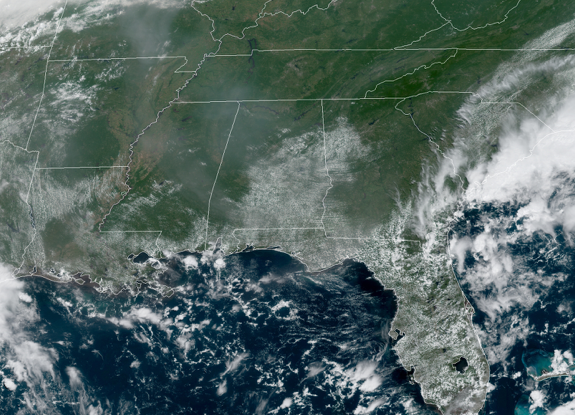
As we are getting close to the start of the midday hour, skies are mostly clear across Central Alabama. You may notice a little haziness in the skies, and that will be due to some smoke that has traveled from the Rockies and the West Coast and has made it into the skies above Central Alabama. Temperatures as of the official 11:00 am readings were in the lower to mid-80s. Montgomery and Tuscaloosa were tied as the warm spots at 85 degrees. Alexander City and Haleyville were tied as the cool spots at 80 degrees. Birmingham was sitting at 83 degrees.
MAINLY DRY & HOT FOR THE REST OF YOUR TUESDAY
Nearly all of Central Alabama will stay dry and mostly sunny through the rest of the daylight hours, but a few isolated showers and thunderstorms may be possible over the extreme southern parts of the area south of a line from Demopolis to Montgomery to Auburn. Afternoon highs will be in the upper 80s to the lower 90s across the area. Any shower activity will dissipate quickly at or just after sunset and we’ll be dry with mainly clear skies through the night and overnight hours. Lows will be in the mid-60s to the lower 70s.
SMALL SHOWER/STORM CHANCES ON WEDNESDAY
Humidity levels start to rise as moisture continues to deepen across Central Alabama. While much of the day will be mostly sunny and hot, a few isolated to scattered afternoon showers and thunderstorms may be possible east of I-65 for the northern half of Central Alabama and south of a line from Demopolis to Clanton to Alexander City. The rest of the area looks to remain dry. Afternoon highs will top out in the lower 90s.
REMAINING BUSY IN THE TROPICS
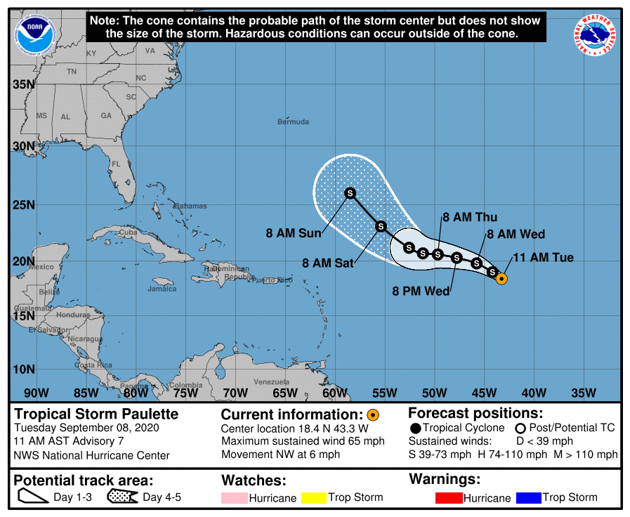
Tropical Storm Paulette continues to strengthen over the Central Tropical Atlantic but she looks to stay a “fish storm” for a good while as there will be no land interaction through the next 5 days. Winds are currently at 65 MPH and some strengthening is expected for today. Paulette may briefly become a hurricane tonight before gradual weakening starts on Wednesday.
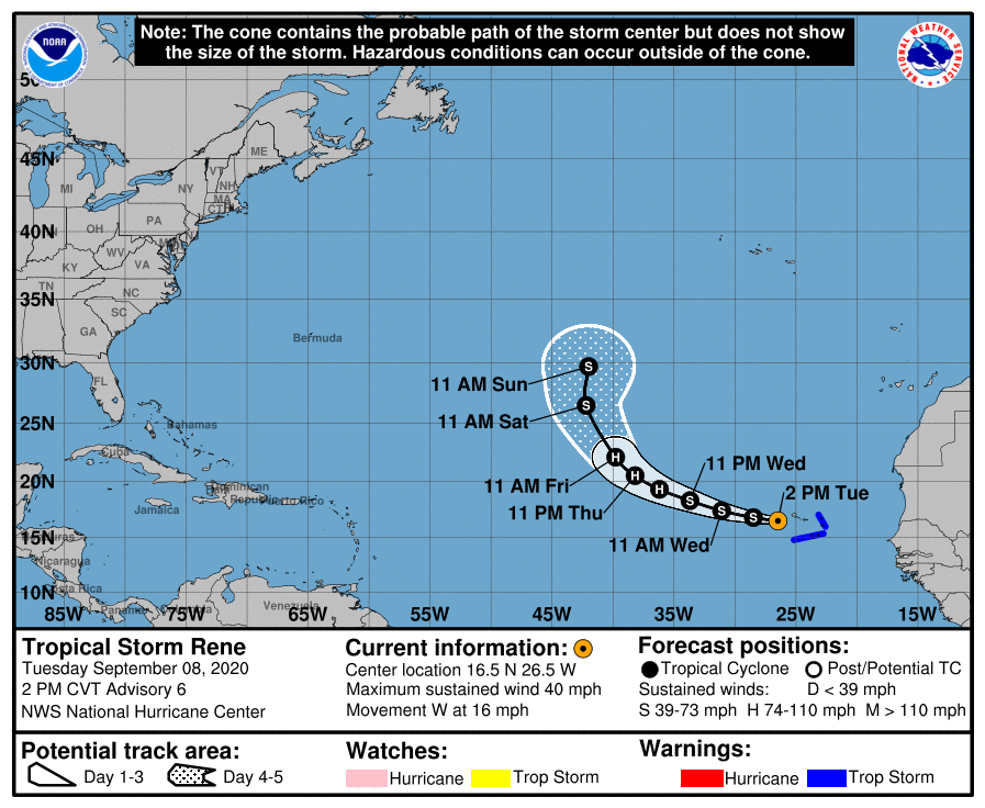
Rene continues to bring tropical storm conditions to the western parts of the Cabo Verde Islands with maximum sustained winds at 40 MPH. Once moving away from the islands today, Rene will move west to west-northwestward for the next 24-48 hours before strengthening starts on Thursday and Friday. Rene is forecast to become a hurricane, but he will be another “fish storm” as he will be no threat to any land after today.
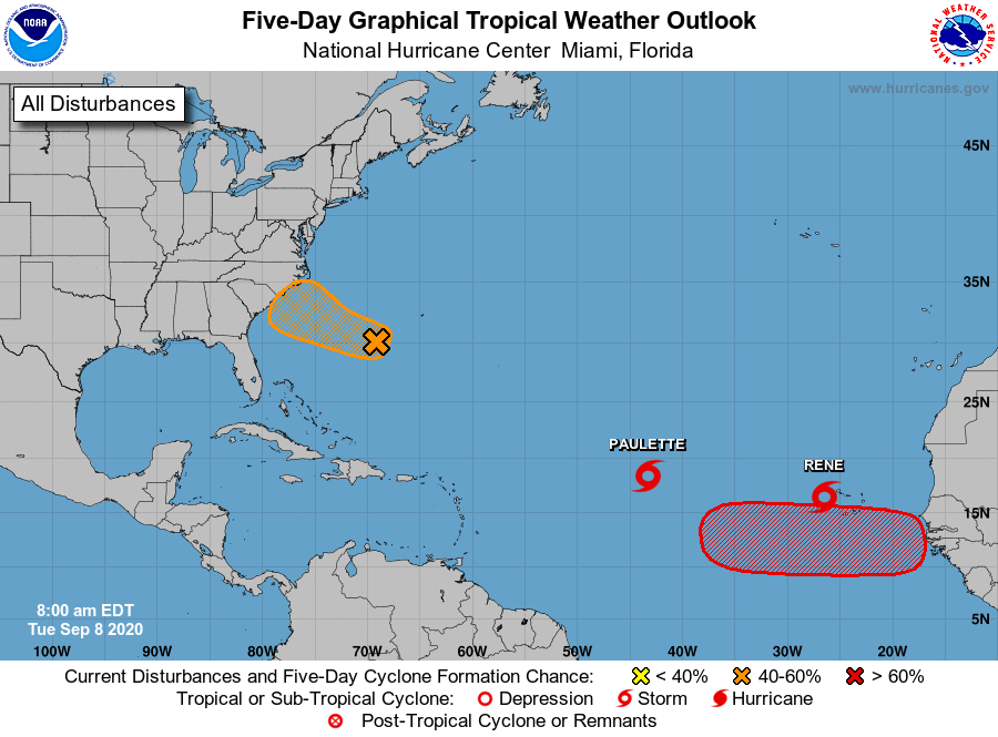
We also have a tropical wave that is forecast to emerge off the west coast of Africa by Thursday. Gradual development is expected once the system moves over water, and a tropical depression is likely to form late this week or over the weekend while the system moves generally westward across the eastern tropical Atlantic.
* Formation chance through 48 hours…low…near 0 percent.
* Formation chance through 5 days…high…70 percent.
And finally, we have an area of low pressure is located about 300 miles west-southwest of Bermuda. Showers and thunderstorm activity associated with the low has increased since last night but remains somewhat disorganized. Gradual additional development of this system is possible during the next two or three days and it could become a tropical depression while it moves slowly westward to west-northwestward. Interests along the southeast coast of the U.S. should monitor the progress of this disturbance.
* Formation chance through 48 hours…low…30 percent.
* Formation chance through 5 days…medium…40 percent.
Category: Alabama's Weather, ALL POSTS, Tropical
About the Author (Author Profile)
Scott Martin is an operational meteorologist, professional graphic artist, musician, husband, and father. Not only is Scott a member of the National Weather Association, but he is also the Central Alabama Chapter of the NWA president. Scott is also the co-founder of Racecast Weather, which provides forecasts for many racing series across the USA. He also supplies forecasts for the BassMaster Elite Series events including the BassMaster Classic.Subscribe
If you enjoyed this article, subscribe to receive more just like it.


