

Paulette a Little Stronger; Expected to Strengthen Further Before Nearing Bermuda Late Sunday & Early Monday
SUMMARY OF 1100 PM AST…0300 UTC…INFORMATION
———————————————–
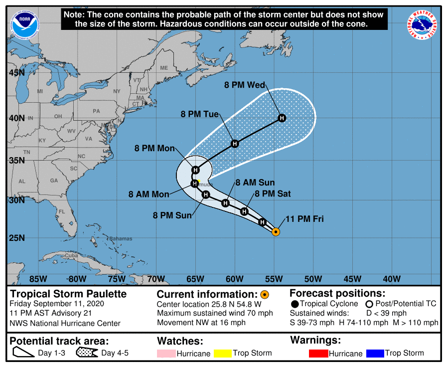
LOCATION…25.8N 54.8W
ABOUT 750 MI…1210 KM SE OF BERMUDA
MAXIMUM SUSTAINED WINDS…70 MPH…110 KM/H
PRESENT MOVEMENT…NW OR 315 DEGREES AT 16 MPH…26 KM/H
MINIMUM CENTRAL PRESSURE…987 MB…29.15 INCHES
WATCHES AND WARNINGS
——————–
A Tropical Storm Watch is in effect for…
* Bermuda
DISCUSSION AND OUTLOOK
———————-
Paulette remains sheared and asymmetric, with all its deep convection north of its low-level center of circulation. Despite the shear, ASCAT-B data that just arrived showed maximum winds near or just over 55 kt. Since that instrument tends to under-sample the maximum winds, the initial intensity is increased to 60 kt.
An upper-level low located to the west of Paulette is responsible for the southerly shear currently affecting the cyclone. Global model forecasts suggest that the shear will continue for another day or so, and only slight strengthening is likely through that period. By Sunday, the upper-level low will move farther southwest and the tropical cyclone will encounter a very favorable upper-air pattern. Paulette will likely strengthen further in response, possibly at a fast rate. All of the intensity guidance indicates that Paulette will be a hurricane when it nears Bermuda early Monday, and it could approach major hurricane strength early next week. The NHC intensity forecast has not changed since the last advisory. It is worth mentioning that Paulette could experience a period of slow development for the next 24 hours, followed by quick intensification, rather than the more steady strengthening shown by the NHC forecast. It is also important to note that the average NHC intensity errors are around 10-15 kt at 48-72 h, the range at which Paulette will likely be nearest to Bermuda.
Paulette has jogged slightly right of the track during the past few hours, but the overall NHC forecast track is not different from the previous advisory. A building mid-level ridge to the north of Paulette will likely steer the tropical storm generally west-northwestward or northwestward for the next 2-3 days. The cyclone is then expected to turn northeastward and accelerate in that direction ahead of a mid-latitude trough. The model spread remains relatively low, especially for the first few days. Confidence is high that Paulette will move near Bermuda early Monday, though it is still too soon to specify exactly how close it will get. The NHC forecast is based heavily on the TVCA and HCCA consensus aids and is not far from any of the global model forecast.
KEY MESSAGES
——————–
1. Paulette is expected to approach Bermuda as a hurricane on Sunday and Monday. A prolonged period of strong winds, storm surge, and heavy rainfall on Bermuda beginning Sunday night is becoming more likely. A tropical storm watch is in effect and a hurricane watch could be required for the island early Saturday.
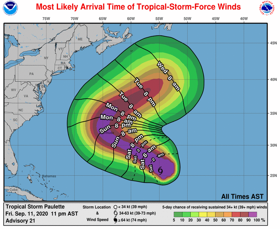
2. Swells produced by Paulette are affecting portions of the Leeward Islands and will continue to spread westward to the Greater Antilles, the Bahamas, Bermuda, and the southeastern United States into the weekend. These swells could cause life-threatening surf and rip current conditions.
Category: ALL POSTS, Severe Weather, Tropical
About the Author (Author Profile)
Scott Martin is an operational meteorologist, professional graphic artist, musician, husband, and father. Not only is Scott a member of the National Weather Association, but he is also the Central Alabama Chapter of the NWA president. Scott is also the co-founder of Racecast Weather, which provides forecasts for many racing series across the USA. He also supplies forecasts for the BassMaster Elite Series events including the BassMaster Classic.Subscribe
If you enjoyed this article, subscribe to receive more just like it.


