TD-19 Has Strengthened into Tropical Storm Sally
SUMMARY OF 200 PM EDT…1800 UTC…INFORMATION
———————————————-
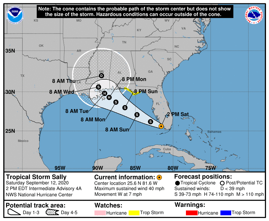
LOCATION…25.6N 81.6W
ABOUT 35 MI…60 KM SSE OF NAPLES FLORIDA
MAXIMUM SUSTAINED WINDS…40 MPH…65 KM/H
PRESENT MOVEMENT…W OR 270 DEGREES AT 7 MPH…11 KM/H
MINIMUM CENTRAL PRESSURE…1004 MB…29.65 INCHES
WATCHES AND WARNINGS
——————–
CHANGES WITH THIS ADVISORY:
None.
SUMMARY OF WATCHES AND WARNINGS IN EFFECT:
A Tropical Storm Watch is in effect for…
* Ochlockonee River to Okaloosa/Walton County Line
A Tropical Storm Watch means that tropical storm conditions are possible within the watch area within the next 48 hours.
Interests elsewhere along the northern Gulf Coast should monitor the progress of this system. Tropical storm or hurricane watches, and storm surge watches, could be issued for a portion of that area later today.
For storm information specific to your area, including possible inland watches and warnings, please monitor products issued by your local National Weather Service forecast office.
DISCUSSION AND OUTLOOK
———————-
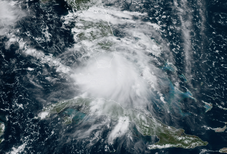
At 200 PM EDT (1800 UTC), the center of Tropical Storm Sally was located near latitude 25.6 North, longitude 81.6 West. The depression is moving toward the west near 7 mph (11 km/h), and a turn toward the west-northwest is expected later today or tonight. A west-northwestward or northwestward motion is then expected during the next couple of days. On the forecast track, the center is forecast to move over the southeastern and eastern Gulf of Mexico later today and Sunday, and then move over the north-central Gulf of Mexico Sunday night and Monday.
Maximum sustained winds have increased near 40 mph (65 km/h) with higher gusts. Additional strengthening is expected over the next couple of days, and Sally is forecast to become a hurricane by late Monday.
Tropical-storm-force winds extend outward up to 80 miles (130 km) south and southeast of the center, just to the south of the Florida Keys.
The estimated minimum central pressure is 1004 MB (29.65 inches).
HAZARDS AFFECTING LAND
———————-
WIND: Wind gusts to tropical-storm-force are possible across the southern portion of the Florida peninsula today, especially over the Florida Keys. Tropical storm conditions are possible in the watch area in the Florida Panhandle by Sunday night.
RAINFALL: Sally is expected to produce total rainfall of 3 to 6 inches with isolated 8-inch amounts over the Florida Keys through tonight with 2 to 4 inches and isolated maximum amounts of 6 inches across southern Florida and the western Florida coast to the Tampa Bay metro area. This rainfall will produce flash and urban flooding across southern Florida and prolong high flows and ongoing minor flooding on rivers across Central Florida.
Sally is expected to produce through Tuesday rainfall of 3 to 6 inches with localized amounts of 8 inches along the Gulf Coast from the Florida Peninsula to southeast Louisiana and 2 to 4 inches farther inland over far southern Alabama, Mississippi, and southeast Louisiana. This is expected to be a slow-moving system that will likely continue to produce heavy rainfall and considerable flooding near the central Gulf Coast through the middle of next week. Flash, urban and rapid onset flooding along small streams and minor to isolated moderate flooding on rivers is likely.
SURF: Swells are expected to spread northward along the west-central coast of Florida and the Florida Panhandle during the next couple of days. These swells are likely to cause life-threatening surf and rip current conditions. Please consult products from your local weather office.
TORNADOES: A tornado or two is possible today and tonight over southern Florida.
Category: Alabama's Weather, ALL POSTS, Severe Weather, Tropical
About the Author (Author Profile)
Scott Martin is an operational meteorologist, professional graphic artist, musician, husband, and father. Not only is Scott a member of the National Weather Association, but he is also the Central Alabama Chapter of the NWA president. Scott is also the co-founder of Racecast Weather, which provides forecasts for many racing series across the USA. He also supplies forecasts for the BassMaster Elite Series events including the BassMaster Classic.Subscribe
If you enjoyed this article, subscribe to receive more just like it.


