Paulette 1:00 pm Update: Paulette Continues to Strengthen While Moving Away from Bermuda
SUMMARY OF 200 PM AST…1800 UTC…INFORMATION
———————————————-
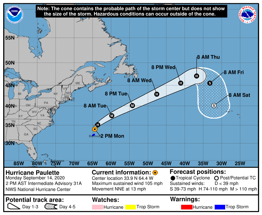
LOCATION…33.9N 64.4W
ABOUT 115 MI…180 KM N OF BERMUDA
MAXIMUM SUSTAINED WINDS…105 MPH…170 KM/H
PRESENT MOVEMENT…NNE OR 020 DEGREES AT 13 MPH…20 KM/H
MINIMUM CENTRAL PRESSURE…965 MB…28.50 INCHES
WATCHES AND WARNINGS
——————–
CHANGES WITH THIS ADVISORY:
The Bermuda Weather Service has replaced the Hurricane Warning for Bermuda with a Tropical Storm Warning.
SUMMARY OF WATCHES AND WARNINGS IN EFFECT:
A Tropical Storm Warning is in effect for…
* Bermuda
DISCUSSION AND OUTLOOK
———————-
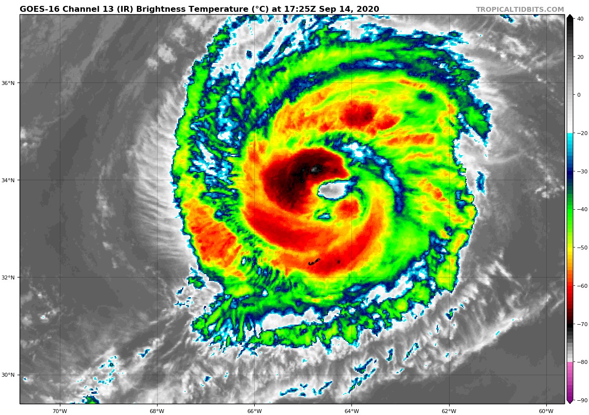
At 200 PM AST (1800 UTC), the eye of Hurricane Paulette was located near latitude 33.9 North, longitude 64.4 West. Paulette is moving toward the north-northeast near 13 mph (20 km/h), and this general motion should continue into the early evening hours. A turn toward the northeast is expected later tonight followed by a turn toward the east-northeast and an increase in forwarding speed Tuesday night through Thursday.
Maximum sustained winds have increased to near 105 mph (170 km/h) with higher gusts. Additional strengthening is likely through Tuesday night as Paulette accelerates northeastward to east-northeastward. Gradual weakening is forecast to begin on Wednesday.
Hurricane-force winds extend outward up to 45 miles (75 km) from the center and tropical-storm-force winds extend outward up to 175 miles (280 km).
The estimated minimum central pressure is 965 MB (28.50 inches).
HAZARDS AFFECTING LAND
———————-
WIND: Tropical storm conditions on Bermuda should persist into the mid to late afternoon hours.
STORM SURGE: A dangerous storm surge is expected to produce significant coastal flooding on Bermuda in areas of onshore winds. Near the coast, the surge will be accompanied by large and destructive waves into this afternoon.
RAIN: Paulette will bring periods of heavy rain to Bermuda through today, with rainfall of 3 to 6 inches expected.
SURF: Swells generated by Paulette are affecting portions of the Leeward Islands, the Greater Antilles, the Bahamas, Bermuda, and the east coast of the United States. These swells are likely to cause life-threatening surf and rip current conditions.
Category: ALL POSTS, Severe Weather, Tropical
About the Author (Author Profile)
Scott Martin is an operational meteorologist, professional graphic artist, musician, husband, and father. Not only is Scott a member of the National Weather Association, but he is also the Central Alabama Chapter of the NWA president. Scott is also the co-founder of Racecast Weather, which provides forecasts for many racing series across the USA. He also supplies forecasts for the BassMaster Elite Series events including the BassMaster Classic.Subscribe
If you enjoyed this article, subscribe to receive more just like it.


