Sally Bringing Life-Threatening Storm Surge, Hurricane-Force Winds, & Flash Flooding to Portions of the Northern Gulf Coast
SUMMARY OF 700 PM CDT…0000 UTC…INFORMATION
———————————————-
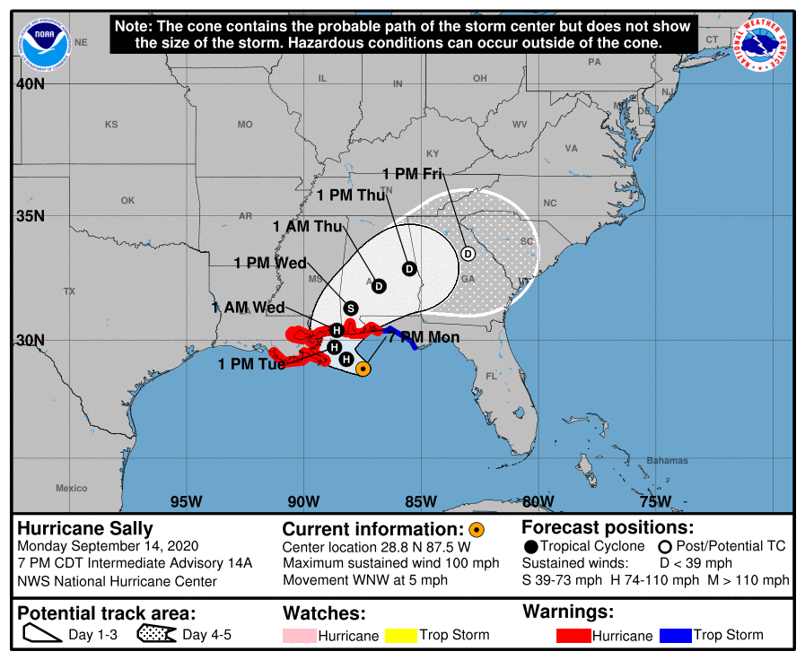
LOCATION…28.8N 87.5W
ABOUT 100 MI…155 KM E OF THE MOUTH OF THE MISSISSIPPI RIVER
ABOUT 135 MI…215 KM SE OF BILOXI MISSISSIPPI
MAXIMUM SUSTAINED WINDS…100 MPH…155 KM/H
PRESENT MOVEMENT…WNW OR 300 DEGREES AT 5 MPH…8 KM/H
MINIMUM CENTRAL PRESSURE…988 MB…29.18 INCHES
WATCHES AND WARNINGS
——————–
A Storm Surge Warning is in effect for…
* Port Fourchon Louisiana to the Okaloosa/Walton County Line Florida
* Lake Pontchartrain, Lake Maurepas, and Lake Borgne
* Mobile Bay
A Hurricane Warning is in effect for…
* Morgan City Louisiana to the Navarre Florida
* Lake Pontchartrain and Lake Maurepas including metropolitan New Orleans
A Tropical Storm Warning is in effect for…
* East of Navarre Florida to Indian Pass Florida
DISCUSSION AND OUTLOOK
———————-
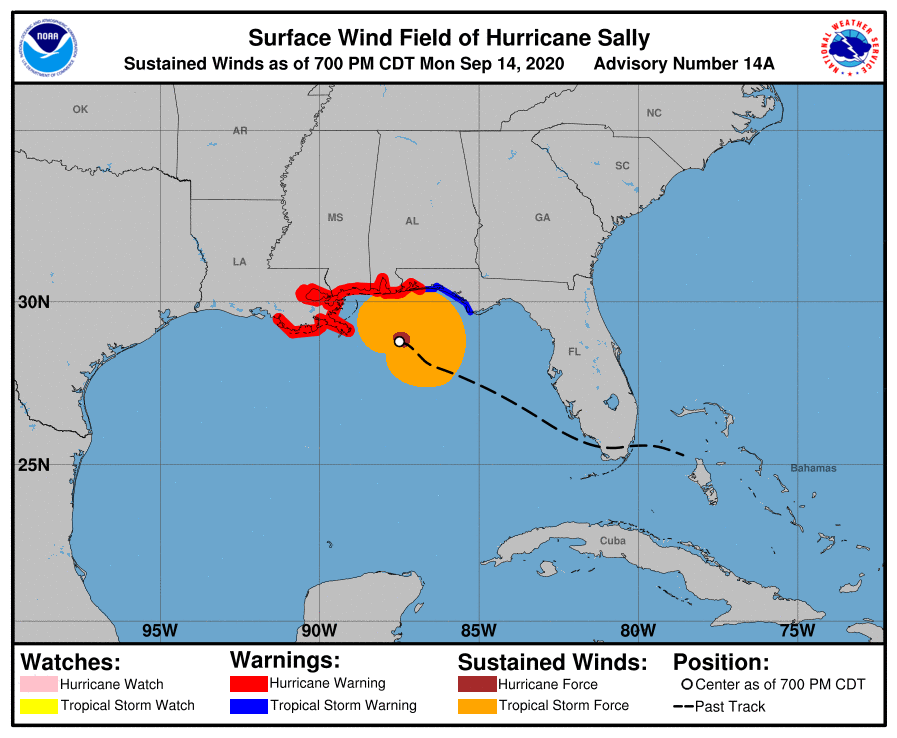
At 700 PM CDT (0000 UTC), the center of Hurricane Sally was located near latitude 28.8 North, longitude 87.5 West. Sally is moving toward the west-northwest near 5 mph (8 km/h), and this motion is expected to continue through Tuesday morning. A northward turn is likely by Tuesday afternoon, and a slow north-northeastward to northeastward motion is expected Tuesday night through Wednesday night. On the forecast track, the center of Sally will move near the coast of southeastern Louisiana tonight and Tuesday, and make landfall in the hurricane warning area Tuesday night or Wednesday.
Data from reconnaissance aircraft indicate that the maximum sustained winds are near 100 mph (155 km/h) with higher gusts. Strengthening is forecast tonight and early Tuesday and Sally are expected to be a dangerous hurricane when it moves onshore along the north-central Gulf Coast.
Hurricane-force winds extend outward up to 25 miles (35 km) from the center and tropical-storm-force winds extend outward up to 125 miles (205 km). A buoy offshore of Orange Beach, Alabama, recently reported sustained winds of 49 mph (79 km/h) and a wind gust of 60 mph (97 km/h).
The minimum central pressure based on data from the Air Force Reserve and NOAA reconnaissance aircraft is 988 MB (29.18 inches).
HAZARDS AFFECTING LAND
———————-
STORM SURGE: The combination of a dangerous storm surge and the tide will cause normally dry areas near the coast to be flooded by rising waters moving inland from the shoreline. The water could reach the following heights above ground somewhere in the indicated areas if the peak surge occurs at the time of high tide…
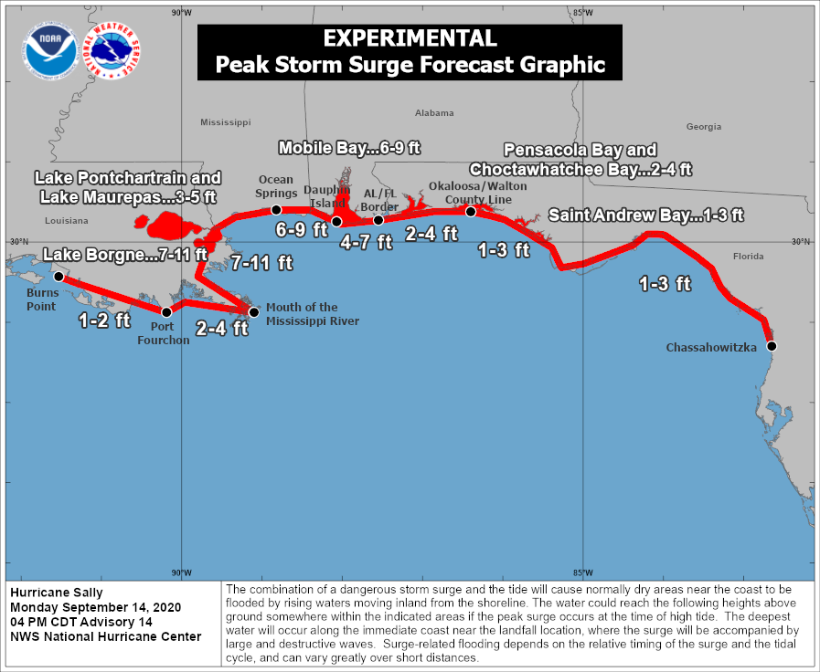
• The mouth of the Mississippi River to Ocean Springs, MS including Lake Borgne…7-11 ft
• Ocean Springs, MS to Dauphin Island, AL including Mobile Bay…6-9 ft
• Dauphin Island, AL to AL/FL Border…4-7 ft
• Lake Pontchartrain and Lake Maurepas…3-5 ft
• Port Fourchon, LA to Mouth of the Mississippi River…2-4 ft
• AL/FL Border to Okaloosa/Walton County Line, FL including Pensacola Bay and Choctawhatchee Bay…2-4 ft
• Okaloosa/Walton County Line, FL to Chassahowitzka, FL including Saint Andrew Bay…1-3 ft
• Burns Point, LA to Port Fourchon, LA…1-2 ft
Overtopping of local levees outside of the Hurricane and Storm Damage Risk Reduction System is possible where local inundation values may be higher than those shown above.
The deepest water will occur along the immediate coast in areas of onshore winds, where the surge will be accompanied by large and damaging waves. Surge-related flooding depends on the relative timing of the surge and the tidal cycle and can vary greatly over short distances.
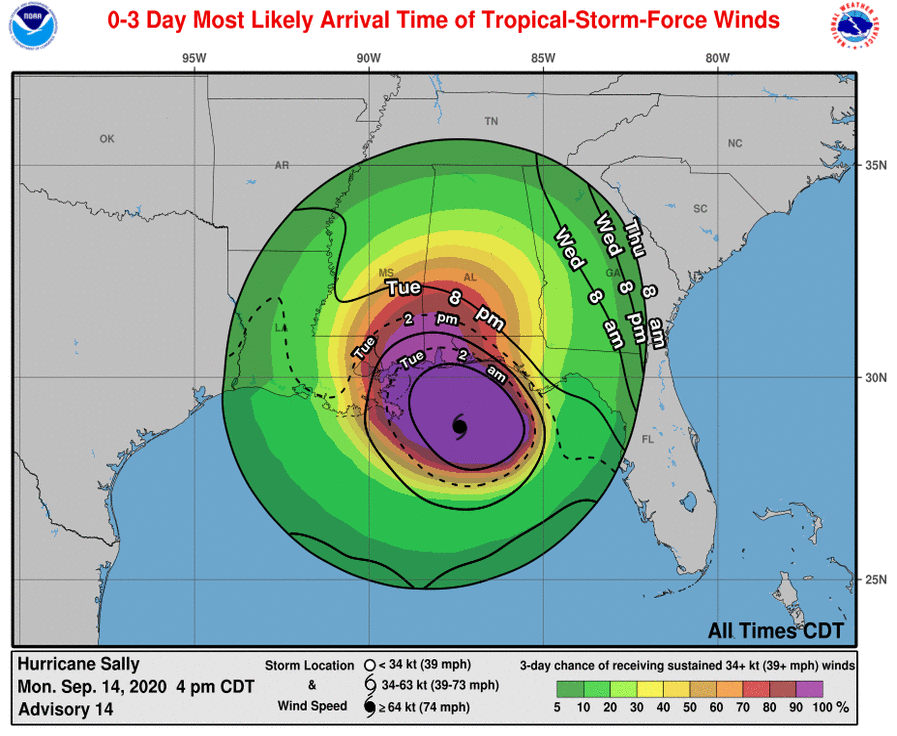
WIND: Hurricane conditions are expected to begin within the hurricane warning area later tonight and Tuesday. Tropical storm conditions expected to begin within the warning area during the next few hours.
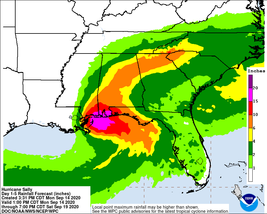
RAINFALL: Sally is expected to be a slow-moving system as it approaches land, producing 8 to 16 inches of rainfall with isolated amounts of 24 inches over portions of the central Gulf Coast from the western Florida Panhandle to far southeast Louisiana through the middle of the week. Life-threatening flash flooding is likely. In addition, this rainfall will likely lead to widespread minor to isolated major flooding on area rivers.
Sally is forecast to move farther inland early Wednesday and track across the Southeast producing rainfall of 4 to 8 inches, with isolated maximum amounts of 12 inches, across portions of eastern Mississippi, central Alabama, northern Georgia and the western Carolinas. Significant flash and urban flooding is likely, as well as widespread minor to moderate flooding on some rivers.
Outer bands of Sally are expected to produce additional rainfall of 1 to 3 inches across the Florida peninsula today. This rainfall may produce flash and urban flooding and prolong high flows and ongoing minor flooding on rivers across central Florida.
TORNADOES: A tornado or two are possible through tonight over coastal areas of the Florida Panhandle and southern Alabama. The threat of tornadoes is expected to increase on Tuesday in these areas, as well as over parts of southern Mississippi and extreme southeast Louisiana.
SURF: Swells from Sally will continue to affect the coast from the Florida Big Bend westward to southeastern Louisiana during the next couple of days. These swells are likely to cause life-threatening surf and rip current conditions.
Category: Alabama's Weather, ALL POSTS, Severe Weather, Tropical
About the Author (Author Profile)
Scott Martin is an operational meteorologist, professional graphic artist, musician, husband, and father. Not only is Scott a member of the National Weather Association, but he is also the Central Alabama Chapter of the NWA president. Scott is also the co-founder of Racecast Weather, which provides forecasts for many racing series across the USA. He also supplies forecasts for the BassMaster Elite Series events including the BassMaster Classic.Subscribe
If you enjoyed this article, subscribe to receive more just like it.


