1:30 am NHC Update: Hurricane Conditions Continue to Spread Onshore from Dauphin Island to Pensacola Beach
SALLY CONTINUES TO STRENGTHEN AS HURRICANE CONDITIONS SPREAD ONSHORE THE GULF COAST FROM PENSACOLA BEACH FLORIDA WESTWARD TO DAUPHIN ISLAND ALABAMA
HISTORIC LIFE-THREATENING FLOODING LIKELY ALONG PORTIONS OF THE NORTHERN GULF COAST
SUMMARY OF 130 AM CDT…0630 UTC…INFORMATION
———————————————-
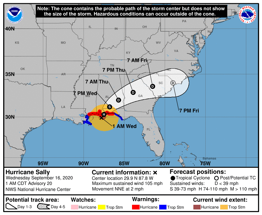
LOCATION…29.9N 87.8W
ABOUT 60 MI…95 KM SSE OF MOBILE ALABAMA
ABOUT 55 MI…90 KM SW OF PENSACOLA FLORIDA
MAXIMUM SUSTAINED WINDS…105 MPH…165 KM/H
PRESENT MOVEMENT…NNE OR 30 DEGREES AT 2 MPH…4 KM/H
MINIMUM CENTRAL PRESSURE…968 MB…28.59 INCHES
WATCHES AND WARNINGS
——————–
A Storm Surge Warning is in effect for…
* Mississippi/Alabama border to the Walton/Bay County Line Florida
* Mobile Bay
A Hurricane Warning is in effect for…
* East of Bay St. Louis Mississippi to the Okaloosa/Walton County line Florida
A Tropical Storm Warning is in effect for…
* East of the Okaloosa/Walton County line Florida to Indian Pass Florida
* Bay St. Louis Mississippi westward to Grand Isle Louisiana
DISCUSSION AND OUTLOOK
———————-
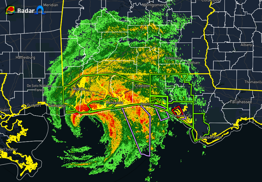
At 130 AM CDT (0630 UTC), the center of Hurricane Sally was located an Air Force Reserve Hurricane Hunter aircraft and NOAA Doppler weather radars near latitude 29.9 North, longitude 87.8 West. Sally is moving toward the north-northeast near 2 mph (4 km/h). A north-northeastward to northeastward motion at a slightly faster forward speed is expected later today and tonight, followed by a faster northeastward motion on Thursday. On the forecast track, the center of Sally will approach the northern Gulf Coast this morning, and make landfall in the hurricane warning area later today. Sally is then expected to move inland across southeastern Alabama tonight.
Recent data from An Air Force Reserve reconnaissance aircraft and the Mobile Alabama Doppler weather radar indicate that maximum sustained winds have increased to near 105 mph (165 km/h) with higher gusts. Some further strengthening is possible before Sally makes landfall. Rapid weakening is expected after landfall occurs.
Hurricane-force winds extend outward up to 40 miles (65 km) from the center and tropical-storm-force winds extend outward up to 125 miles (205 km). A sustained wind of 81 mph (130 km/h) with a gust to 110 mph (178 km/h) was recently reported in Sally’s northern eyewall by NOAA buoy 42012, located about 50 miles southeast of Mobile, Alabama. A sustained wind of 72 mph (117 km/h) and a gust to 90 mph (144 km/h) were recently measured by the NOAA C-MAN observing station on Dauphin Island, Alabama.
The minimum central pressure recently reported by the Hurricane Hunters was 968 MB (28.58 inches).
HAZARDS AFFECTING LAND
———————-
RAINFALL: Sally is forecast to produce 10 to 20 inches of rainfall with isolated amounts of 30 inches along and just inland of the central Gulf Coast from the Florida Panhandle west of the Apalachicola River to the Alabama/Mississippi border. Historic, life-threatening flash flooding is likely. In addition, this rainfall will lead to widespread moderate to major flooding on area rivers.
Sally is forecast to turn inland today and track across the Southeast producing rainfall of 4 to 8 inches, with isolated maximum amounts of 12 inches, across portions of southeastern Mississippi, southern and central Alabama, central and northern Georgia, and the western Carolinas. Significant flash and urban flooding is likely, as well as widespread minor to moderate flooding on some rivers.
STORM SURGE: The combination of a dangerous storm surge and the tide will cause normally dry areas near the coast to be flooded by rising waters moving inland from the shoreline. The water could reach the following heights above ground somewhere in the indicated areas if the peak surge occurs at the time of high tide…
* Dauphin Island AL to Okaloosa/Walton County FL Line…4-7 ft
* Pensacola Bay and Choctawhatchee Bay FL…4-7 ft
* Mobile Bay…3-5 ft
* Okaloosa/Walton County Line to Walton/Bay County line FL…2-4 ft
* The mouth of the Mississippi River to MS/AL Border including Lakes Pontchartrain, Maurepas, and Borgne…1-3 ft
* MS/AL Border to Dauphin Island AL…2-4 ft
* Walton/Bay County line to Chassahowitzka FL including Saint Andrew Bay…1-3 ft
The deepest water will occur along the immediate coast in areas of onshore winds, where the surge will be accompanied by large and damaging waves. Surge-related flooding depends on the relative timing of the surge and the tidal cycle and can vary greatly over short distances.
WIND: Hurricane conditions are spreading onshore within the hurricane warning area in Florida and Alabama. Tropical storm conditions will continue in portions of the warning areas through tonight.
TORNADOES: A few tornadoes may occur through today across portions of the Florida Panhandle and southern Alabama.
SURF: Swells from Sally will continue to affect the coast from the Florida Big Bend westward to southeastern Louisiana during the next couple of days. These swells are likely to cause life-threatening surf and rip current conditions.
Category: Alabama's Weather, ALL POSTS, Severe Weather, Tropical
About the Author (Author Profile)
Scott Martin is an operational meteorologist, professional graphic artist, musician, husband, and father. Not only is Scott a member of the National Weather Association, but he is also the Central Alabama Chapter of the NWA president. Scott is also the co-founder of Racecast Weather, which provides forecasts for many racing series across the USA. He also supplies forecasts for the BassMaster Elite Series events including the BassMaster Classic.Subscribe
If you enjoyed this article, subscribe to receive more just like it.


