Mostly Cloudy & Mild at Midday
A LOOK OUT THE WINDOW AT 11:30 AM
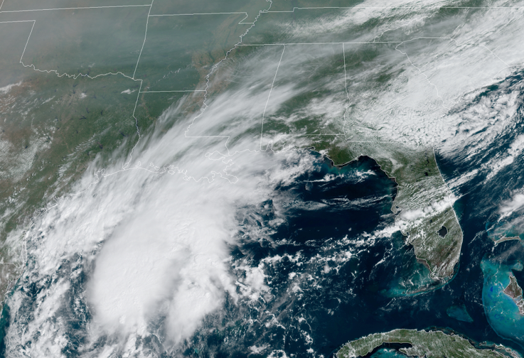
I know it is a wider-shot that you would usually see for the visible satellite image for Central Alabama but just wanted to show you exactly where our cloud cover was coming from. That just off of the coast of Texas is TD-22, and clouds from the north and northeastern periphery were moving into the area. Also, we see some smoke in the higher levels of the atmosphere floating in from the wildfires out west, but that will not affect us at the surface. Plus, we do have some cloud cover in the eastern parts from the remnants of Sally combined with a cold front. Temperatures were in the lower 70s to the lower 80s as of the 11:00 am roundup. Haleyville was the cool spot at 72 degrees. Birmingham, Tuscaloosa, and Troy were all tied as the warm spot at 80 degrees.
WEATHER FOR THE REST OF YOUR FRIDAY
Skies will continue to be mostly cloudy through the rest of the daylight hours across Central Alabama as high clouds continue to stream in from the southwest off of the northeastern periphery of TD-22. While we do not expect any shower activity for much of Central Alabama, a few isolated showers may be possible for locations in the extreme east and southeastern parts of the area. Afternoon highs will top out in the upper 70s to the mid-80s. By the time we get to the late-night hours, the shower activity will have diminished but those clouds will continue to linger through the overnight hours. A few isolated showers may sneak into the extreme southern and southeastern parts of the area just before dawn. Lows will be in the upper 50s to the upper 60s.
SATURDAY’S WEATHER
Skies will once again feature clouds streaming in from the southwest from TD-22 and some moisture may work its way into the southern parts of the area mainly south of a line from Demopolis to Clanton to Alexander City. There will be a small chance of showers over those locations, while the rest of Central Alabama will remain dry and mild. Highs will be in the mid to upper 70s. Saturday night looks to be dry after sunset with temperatures falling to the mid to upper 60s by the late local news and to the mid-50s to the lower 60s for the overnight lows.
ON THIS DAY IN WEATHER HISTORY (by WeatherForYou.com)
1926 – The great “Miami Hurricane” produced winds reaching 138 mph which drove ocean waters into the Biscayne Bay drowning 135 persons. The eye of the hurricane passed over Miami, at which time the barometric pressure reached 27.61 inches. Tides up to twelve feet high accompanied the hurricane, which claimed a total of 372 lives.
1989 – Hurricane Hugo hit Puerto Rico, producing wind gusts to 92 mph at San Juan, and wind gusts to 120 mph at Roosevelt Roads. Hugo produced a storm surge of four to six feet, and northeastern sections of the island were deluged with more than ten inches of rain. Hugo claimed the lives of a dozen persons in Puerto Rico, and caused a billion dollars damage, including 100 million dollars damage to crops. Thunderstorms representing what remained of Hurricane Octave continued to bring heavy rain to the valleys of northern California. Heavier 24-hour rainfall totals included 3.15 inches at Redding and 2.66 inches at Red Bluff.
Category: Alabama's Weather, ALL POSTS, Tropical
About the Author (Author Profile)
Scott Martin is an operational meteorologist, professional graphic artist, musician, husband, and father. Not only is Scott a member of the National Weather Association, but he is also the Central Alabama Chapter of the NWA president. Scott is also the co-founder of Racecast Weather, which provides forecasts for many racing series across the USA. He also supplies forecasts for the BassMaster Elite Series events including the BassMaster Classic.Subscribe
If you enjoyed this article, subscribe to receive more just like it.


