Tropical Storm Warnings Issued for the Texas & Louisiana Coasts; Beta Making Westward Turn
BULLETIN
Tropical Storm Beta Advisory Number 8…Corrected
NWS National Hurricane Center Miami FL AL222020
1000 AM CDT Sat Sep 19 2020
BETA STARTING ITS WESTWARD TURN
TROPICAL STORM WARNING ISSUED FOR PORTIONS OF THE TEXAS AND LOUISIANA COASTS
SUMMARY OF 1000 AM CDT…1500 UTC…INFORMATION
———————————————–
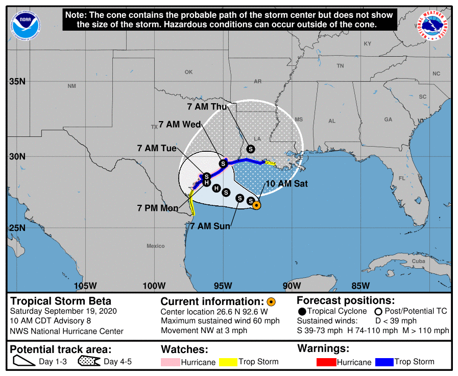
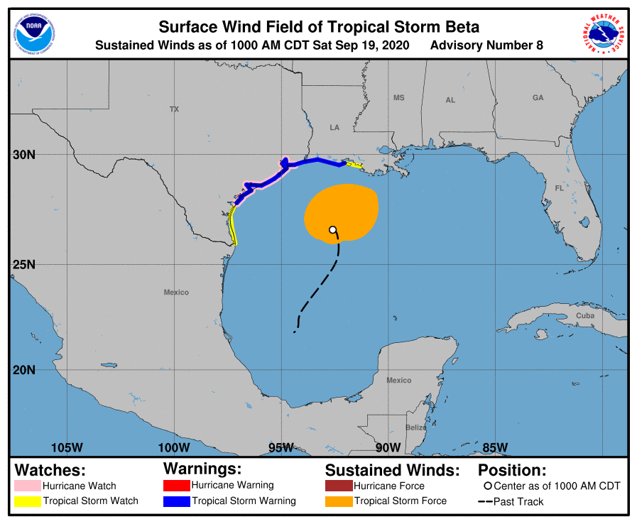
LOCATION…26.6N 92.6W
ABOUT 305 MI…495 KM ESE OF CORPUS CHRISTI TEXAS
ABOUT 245 MI…395 KM S OF LAKE CHARLES LOUISIANA
MAXIMUM SUSTAINED WINDS…60 MPH…95 KM/H
PRESENT MOVEMENT…NW OR 315 DEGREES AT 3 MPH…6 KM/H
MINIMUM CENTRAL PRESSURE…994 MB…29.36 INCHES
WATCHES AND WARNINGS
——————–
A Storm Surge Watch is in effect for…
* Port Mansfield, TX to Cameron, LA including Baffin Bay, Corpus Christi Bay, Copano Bay, Aransas Bay, San Antonio Bay, Matagorda Bay, Galveston Bay, Sabine Lake, and Calcasieu Lake
A Hurricane Watch is in effect for…
* Port Aransas Texas to High Island Texas
A Tropical Storm Warning is in effect for…
* Port Aransas Texas to Intracoastal City Louisiana
A Tropical Storm Watch is in effect for…
* South of Port Aransas Texas to the Mouth of the Rio Grande
* East of Intracoastal City Louisiana to Morgan City Louisiana
DISCUSSION AND OUTLOOK
———————-
At 1000 AM CDT (1500 UTC), the center of Tropical Storm Beta was located near latitude 26.6 North, longitude 92.6 West. Beta is moving toward the northwest near 3 mph (6 km/h). A slow westward motion is expected to begin later today, with a slow northwestward motion forecast to begin late Sunday or Sunday night and continue through late Monday. On the forecast track, the center of Beta will slowly approach the Texas coast into early next week.
Maximum sustained winds are near 60 mph (95 km/h) with higher gusts. Little change in strength is expected today. After that, slow strengthening is forecast, and Beta is expected to be at or near hurricane strength Sunday night or Monday.
Tropical-storm-force winds extend outward up to 175 miles (280 km) from the center.
The estimated minimum central pressure is 994 MB (29.36 inches).
HAZARDS AFFECTING LAND
———————-
STORM SURGE: The combination of a dangerous storm surge and the tide will cause normally dry areas near the coast to be flooded by rising waters moving inland from the shoreline. The water could reach the following heights above ground somewhere in the indicated areas if the peak surge occurs at the time of high tide…
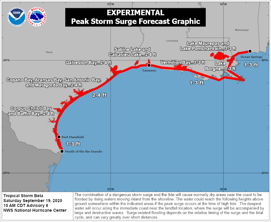
* Port Mansfield, TX to Cameron, LA including Baffin Bay, Corpus Christi Bay, Copano Bay, Aransas Bay, San Antonio Bay, Matagorda Bay, Galveston Bay, Sabine Lake, and Calcasieu Lake…2-4 ft
* The mouth of the Rio Grande, TX to Port Mansfield, TX…1-3 ft
* Cameron, LA to Ocean Springs, MS including Vermilion Bay…1-3 ft
* Lake Maurepas, Lake Pontchartrain, and Lake Borgne…1-3 ft
The deepest water will occur along the immediate coast in areas of onshore winds, where the surge will be accompanied by large and dangerous waves. Surge-related flooding depends on the relative timing of the surge and the tidal cycle and can vary greatly over short distances. For information specific to your area, please see products issued by your local National Weather Service forecast office.
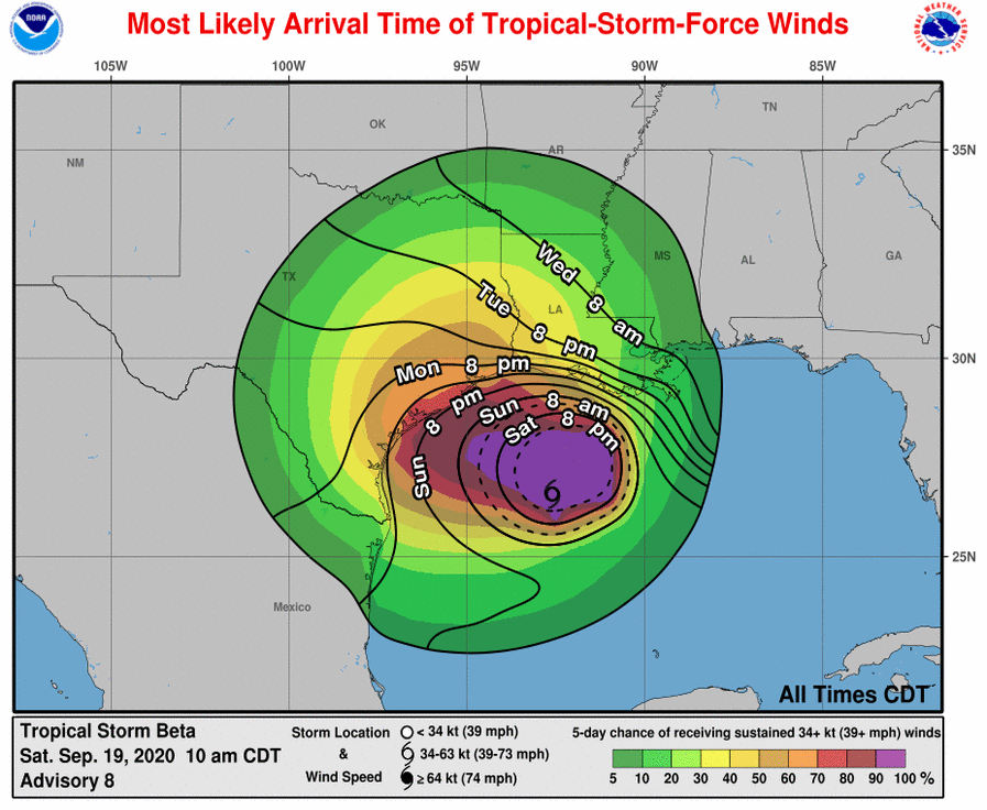
WIND: Tropical storm conditions are expected in the tropical storm Warning area by late Sunday or Sunday night. Hurricane conditions are possible within the hurricane watch area by late Monday or Monday night. Tropical storm conditions are possible within the tropical storm watch area along the southwestern Louisiana coast as early as tonight. Tropical storm conditions are possible within the tropical storm watch area along the south Texas coast Sunday night
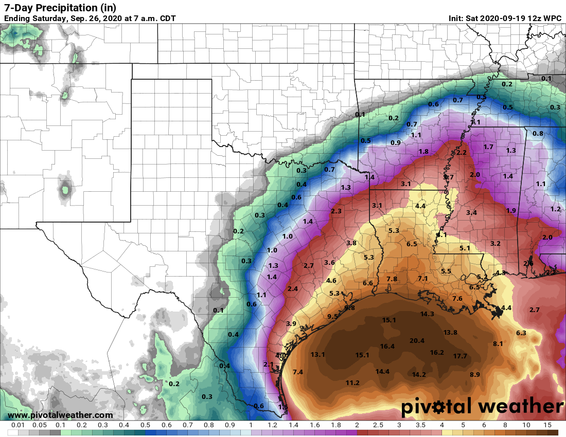
RAINFALL: Beta has the potential to produce a long-lived rainfall event along the western Gulf Coast. Today through Tuesday, Beta is expected to produce rainfall accumulations of 3 to 5 inches with isolated totals of 10 inches beginning Saturday across southern Louisiana and spreading into coastal Texas on Sunday. Flash and urban flooding is likely as well as minor river flooding. Additional heavy rainfall amounts across the western Gulf Coast are possible through late week as Beta is expected to move slowly near the Texas coast.
SURF: Swells are expected to increase and reach the coast of Texas and the Gulf Coast of Mexico later today, generated by a combination of Beta and a cold front entering the northern Gulf of Mexico. These swells are likely to cause life-threatening surf and rip current conditions. Please consult products from your local weather office.
Category: ALL POSTS, Severe Weather, Tropical
About the Author (Author Profile)
Scott Martin is an operational meteorologist, professional graphic artist, musician, husband, and father. Not only is Scott a member of the National Weather Association, but he is also the Central Alabama Chapter of the NWA president. Scott is also the co-founder of Racecast Weather, which provides forecasts for many racing series across the USA. He also supplies forecasts for the BassMaster Elite Series events including the BassMaster Classic.Subscribe
If you enjoyed this article, subscribe to receive more just like it.


