

Sunday Weather Extreme: Big Changes are on the Way
September will come to an end this week, and it looks like it will end slightly above normal in the temperature department, despite a big change to cooler that is coming tomorrow night. Rainfall totals in September have been feast or famine, with the I-59 Corridor landing in the famine category, while virtually everyone else has been feast. South and southeastern Alabama did well because of Hurricane Sally of course, with totals running 5-8 inches above normal. Northwestern Alabama has done well as well, running 4-6 inches above normal. The Birmingham Airport sits at 0.99 inches of rain for the month, which is 2.24 inches below normal. Another one quarter to one-half of an inch of rain is possible before the end of the month at Birmingham.
ON THE WEATHER MAPS: A powerful upper trough is building down into the northern tier of states presently. This trough will bring a big change to fall-like weather to much of the country including Alabama and the Deep South. Elsewhere in the upper reaches of our atmosphere, there is a weakness over Louisiana. A weak surface low will form this morning along the Gulf Coast near Mobile and track eastward.
FOR YOUR SUNDAY: As the lower levels of the atmosphere have moistened this morning, low clouds and fog have developed. Light showers will develop over Alabama today, and there may be some thunder. It will be warm and humid, with highs in the lower and middle 80s. Dewpoints will be in the middle 60s. Clouds will be thick at times, although sun may increase a bit in the afternoon. Lows tonight will be in the middle 60s generally, and it should be mainly dry.
ONE LAST WARM DAY: By tomorrow morning, that powerful trough will be digging southward, pushing a strong cold front ahead of it. A few showers will reach northwestern sections during the morning hours, and there could be a little thunder as this activity expands during the afternoon. The front will reach I-59 by sunset, pushing rapidly southeast and producing gusty winds out of the west and northwest. Widespread rain will push slowly through the area Monday afternoon and will continue much of Monday evening. When it is all said and done, rainfall totals will run one-half inch or less generally. There will be a wide range in temperatures on Monday, with highs in the Northwest around 70F, with upper 70s across the rest of North Alabama, lower and middle 80s across Central Alabama, and upper 80s over South Central Alabama. Lows by morning will be in the upper 40s northwest to middle 50s in the I-59 Corridor and upper 50s to the southeast.
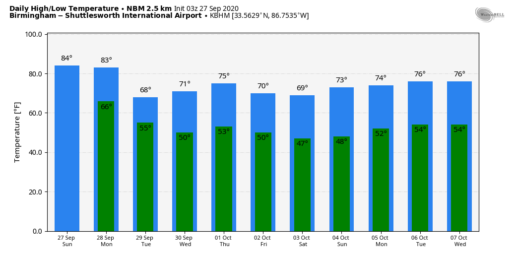
Temps off the National Blend of Models for Birmingham
TUESDAY COOLDOWN: Tuesday will feature a sunny start over northwestern sections and retreating clouds to the southeast. Stratocumulus clouds will form during the day, leading to partly cloudy to partly sunny skies at times. Highs will be centered around 70F, with upper 60s northwest, and lower 70s southeast. Expect widespread 40s across the area Tuesday night.
WEDNESDAY/THURSDAY: High pressure will be in charge, so expect a good supply of sunshine each day, with highs in the lower and middle 70s. Lows Wednesday night will be in the 50s. A reinforcing shot of cooler air will arrive Thursday night.
FRIDAY INTO THE WEEKEND: That reinforcing shot of cooler and drier air will set the stage for a nice weekend, with highs in the 60s Friday and near 70F on Saturday. There could be clouds and an isolated shower on Sunday as another trough builds over the eastern U.S.
VOODOOLAND: That second week of the forecast period looks like it might involve a frontal system just to our north with rain chances best over the Tennessee Valley. We will be watching the western Caribbean for tropical development, but it is unclear what that might look like. Most recent model runs have shunted anything out across the Bahamas and over the open Atlantic. We’re good with that here in the Southeast.
BEACHCAST: Partly cloudy skies with a chance of shower and storms will prevail through Tuesday before the front brings drier air to the Gulf Coast. Highs will be in the 80s through Monday, with 70s prevailing the rest of the week. Lows that are now in the lower 70s now, with fall back into the 50s by Wednesday morning and will stay there into the weekend. Water temperatures are in the mid 70s. The rip current risk will be low for the next several days.
Click here to see the Beach Forecast Center page.
WEATHERBRAINS: This week, the panel will entertain Buffalo TV Meteorologist Don Paul. Check out the show at www.WeatherBrains.com. You can also subscribe on iTunes. You can watch the show live at live.bigbrainsmedia.com or on James’ YouTube Channel You will be able to see the show on the James Spann 24×7 weather channel on cable or directly over the air on the dot 2 feed.
ON THIS DATE IN 2010: Wilmington NC recorded its second-highest single-day rainfall total as 10.33 inches of rain fell. The amount was second only to the 13.38 inches that fell on September 15, 1999, during Hurricane Floyd. The heavy rainfall was caused by tropical moisture that was streaming northward ahead of a low-pressure system moving northeastward out of the Gulf States. Follow my weather history tweets on Twitter. I am @wxhistorian at Twitter.com.
Category: Alabama's Weather, ALL POSTS
About the Author (Author Profile)
Bill Murray is the President of The Weather Factory. He is the site's official weather historian and a weekend forecaster. He also anchors the site's severe weather coverage. Bill Murray is the proud holder of National Weather Association Digital Seal #0001 @wxhistorianSubscribe
If you enjoyed this article, subscribe to receive more just like it.


