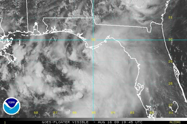
The Latest on Claudette…Including Coastal Reports

FAST FACTS AS OF 4 PM CDT
LOCATION…29.5N 85.6W
MAXIMUM SUSTAINED WINDS…50 MPH
PRESENT MOVEMENT…NORTHWEST OR 315 DEGREES AT 14 MPH
MINIMUM CENTRAL PRESSURE…1008 MB
The center of Claudette became exposed this afternoon, but deep convection is developing around the center again.
INTENSITY FORECAST
Claudette could strengthen slightly before landfall. Top winds will be in the 50-60 mph range at landfall. A tower 25 miles SSW of Apalachicola reported a sustained wind of 51 mph a short time ago.
LANDFALL
Claudette should make landfall near Destin around 9-10 p.m.
AFFECTS
Tropical storm warnings are in effect from the FL/AL border to the mouth of the Suwanee River.
No evacuations in effect.
COASTAL SECTIONS
Winds of 55-65 mph will accompany Claudette over Northwest Florida. Mobile homes can be damaged by these winds and should be abandoned for safer shelter.
Storm surge 3-6 feet near and east of where center crosses the coast, including the Florida Big Bend.
Rainfall 3-6 inches with isolated 10 inch amounts. Flash flood watches in effect
A few tornadoes possible over Northwest Florida and South Alabama, mainly east of the center track.
CENTRAL ALABAMA
Winds will gradually increase and average 8-16 with higher gusts to 30 mph late tonight and Monday. A tropical storm wind warning is in effect for South and Southeast Alabama from the Montgomery area south and southeast.
Rainfall of 1-2 inches is expected. Flash flood watches for SE Alabama.
There could be a few isolated small spin up tornadoes east of the track Monday over Central Alabama.
Scroll down for more more information from Tim Coleman and James on Claudette.
COASTAL REPORTS
MOBILE…Partly sunny…NE 10
FLORALA…Partly sunny…SE 16 G 30
DESTIN…Cloudy…E 6
PANAMA CITY…Cloudy…E 15 G 23 Pressure 29.99F
APALACHICOLA…Rain/Fog…SE 24G40…Pressure 29.97F
BUOY 42036…45 miles south of Apalachicola…SSE 31 G 41…Seas 9 feet…pressure 29,99S
BUOY 42039…50 miles SSW of Panama City…NW 8 G 11…Seas 5 feet…pressure 29,96F
CAMILLE INFORMATION
The historical posts on Camille will be pushed “below the fold” on the blog through tomorrow. They will be there, but information on Claudette and inland hazardous weather will be pushed to the top. I will also create a category for all the Camille posts (James’ great suggestion) so you can read them all later if you like. I hope that you enjoy them. I appreciate the nice notes several people sent.
Category: Uncategorized


