Delta Rapidly Intensifying; Gamma Likely to Become a Remnant Low Tonight
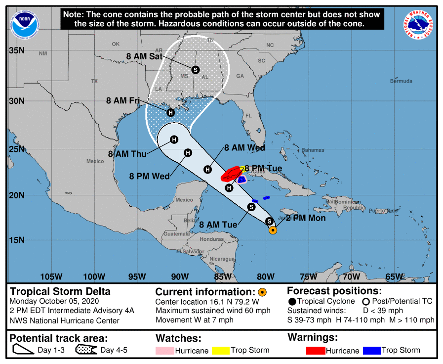
TROPICAL STORM DELTA – 1:00 PM UPDATE
Hurricane Hunter Aircraft is en route to the rapidly intensifying Tropical Storm Delta, as maximum sustained winds are at 60 MPH and moving to the west at 7 MPH. The center is currently located around 255 miles south-southeast of the Grand Cayman Islands and the pressure has dropped to 998 MB. While a turn to the west-northwest is forecast later today, a faster northwestward motion is expected on Tuesday and Wednesday.
On the forecast track, the center of Delta is expected to move away from Jamaica later today, move near or over the Cayman Islands early Tuesday, and approach western Cuba and the Yucatan Channel Tuesday afternoon or evening. Delta is forecast to move into the southeastern Gulf of Mexico Tuesday night, and be over the south-central Gulf of Mexico on Wednesday. Additional strengthening is expected during the next few days, and Delta is expected to become a hurricane tonight or Tuesday before it nears western Cuba.
Tropical storm conditions are expected in the Cayman Islands beginning late today or tonight, and a Tropical Storm Warning is in effect. Dangerous storm surge and hurricane conditions are expected in portions of western Cuba by Tuesday afternoon, and a Hurricane Warning is in effect. Heavy rainfall will affect portions of Jamaica, the Cayman Islands, and western Cuba during the next few days. This rainfall could lead to significant flash flooding and mudslides.
Delta is forecast to approach the northern Gulf Coast late this week as a hurricane. While there is large uncertainty in the track and intensity forecasts at these time ranges, there is an increasing risk of dangerous storm surge, wind, and rainfall hazards along the coast from Louisiana to the western Florida Panhandle. Residents in these areas should monitor the progress of Delta and check for updates to the forecast during the week.
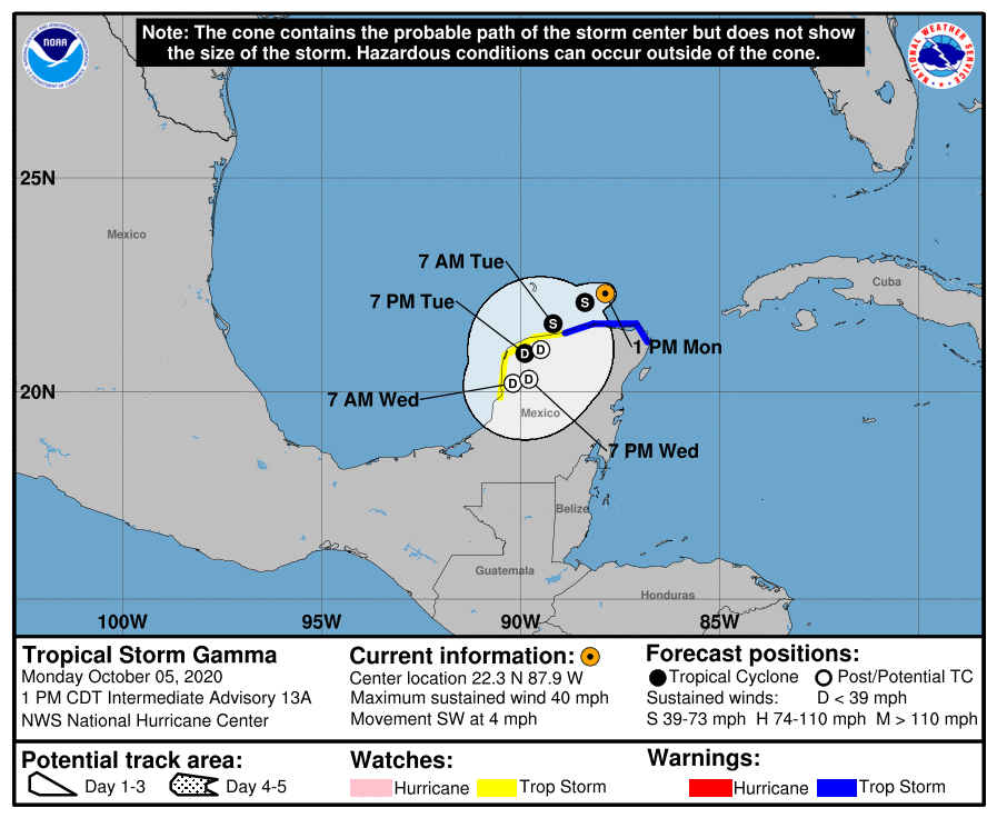
TROPICAL STORM GAMMA – 1:00 PM UPDATE
Gamma continues to become less organized and weakening as the maximum sustain winds are down to 40 MPH and the pressure is up to 1003 MB. The center is located around 135 miles north-northwest of Cozumel, Mexico, and is moving to the southwest at 4 MPH. This general motion is expected to continue through Wednesday morning. On the forecast track, the center of Gamma should move inland over the northwest coast of the Yucatan Peninsula Tuesday night and remain inland through Thursday. Gradual weakening is forecast, and Gamma is expected to become a depression this evening and will degenerate into a post-tropical remnant low tonight.
Through midweek, Gamma is expected to produce an additional 3 to 6 inches of rainfall with isolated maximum amounts of 8 inches across portions of the Mexican states of Yucatan, Campeche, and Tabasco. This rainfall may produce significant flash flooding. Tropical storm conditions are likely in portions of the Tropical Storm Warning area along the northern coast of the Yucatan Peninsula for a brief period this afternoon. Tropical Storm conditions are possible within the Tropical Storm Watch area.
Category: ALL POSTS, Severe Weather, Tropical
About the Author (Author Profile)
Scott Martin is an operational meteorologist, professional graphic artist, musician, husband, and father. Not only is Scott a member of the National Weather Association, but he is also the Central Alabama Chapter of the NWA president. Scott is also the co-founder of Racecast Weather, which provides forecasts for many racing series across the USA. He also supplies forecasts for the BassMaster Elite Series events including the BassMaster Classic.Subscribe
If you enjoyed this article, subscribe to receive more just like it.


