Delta Now Has Winds of 140 mph: A Few Notes and the Advisory at 1 p.m.
The winds in Hurricane Delta in the western Caribbean continue to increase, but the pressure has leveled off. Top winds are now 140 mph and the pressure is 957 mb. The pressure should be much lower for those wind speeds.
There is likely more room for intensification and Delta will remain a category 4 hurricane until reaching the Yucatan tomorrow morning.
The storm is over very high oceanic heat content water, wind shear is low (10-15 knots) and there is no dry air currently threatening to be entrained into the circulation so there is more room for intensification.
Is there a chance that Delta could become a category 5 before reaching the Yucatan? The morning SHIPS model data indicated about a 35% chance of that.
The hurricane will deal a devastating blow to the northeastern Yucatan including Cozumel. Tides will reach 7-11 feet along the northern coast, and 6-9 feet along the northeastern coast, including Cozumel. Tropical storm force winds will begin on the northeastern Yucatan later today and tonight with hurricane conditions by early morning.
The hurricane will drop back a bit to around 120 mph during its transit over the Yucatan. Wind shear is expected to actually decrease to less than 10 knots 24 hours from now and will remain low over the southern and Central Gulf through 60 hours (Thursday afternoon). This will allow the hurricane to re-intensify to about 130-135 mph over the southern and Central Gulf.
Fortunately, the shear should increase as the hurricane moves northward through the northern Gulf Thursday night and Friday, leading to some weakening, but Delta will still be a dangerous hurricane when it reaches the coast Friday night, most likely as a 120 mph hurricane.
The most likely landfall will be along the Central Louisiana coast between Vermillion Bay and Grand Isle, most likely near Morgan City near midnight Friday night. Tropical storm force winds will begin early Friday afternoon along the Louisiana coast ahead of the storm, with increasing winds Friday evening, reaching hurricane force a couple of hours before the center in the landfall zone.
The forecast cone still extends from Baymont to Fort Walton, which of course includes all of the Alabama coast, as well as Mississippi, and the western Florida Panhandle.
A deadly storm surge will impact the Gulf Coast near and east of where the center comes inland. Surge values could reach 12-16 feet with some 16-20 foot values in spots along the Louisiana coast if a category 3 hurricane makes landfall. It is too early to understand what surge impacts could be elsewhere in southeastern Louisiana, Mississippi, Alabama, and the western Florida Panhandle.
Winds will be 45-55 mph in New Orleans with gusts to 65 mph, with the chance that winds could be higher with a more easterly track.
On the Alabama coast, winds could reach 30-35 mph with gusts to 45 mph. Of course, a more easterly track could result in much higher wind impacts.
Across the Florida Panhandle, winds could reach 15-25 mph with gusts to 30 mph, and as stated, a more easterly track could result in much higher wind impacts.
For Central Alabama, it will become breezy on Friday, with winds averaging 10-15 mph with gusts to 20 mph. It will become windy Saturday, with winds averaging 10-20 mph with gusts to 30-35 mph. There will be gusts to 40-45 mph over Northwest Alabama.
It will remain breezy through Sunday.
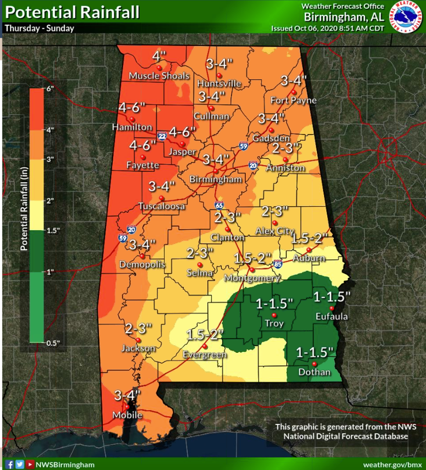
Rainfall amounts will be 4-6 inches in West Alabama, 3-4 inches in the I-59 Corridor, and 1-3 inches in the rest of Central Alabama.
There will be a small chance of a few spin-up tornadoes over West Alabama on Saturday.
Here’s the advisory.
BULLETIN
Hurricane Delta Intermediate Advisory Number 8A
NWS National Hurricane Center Miami FL AL262020
200 PM EDT Tue Oct 06 2020
…CATEGORY FOUR HURRICANE DELTA TAKING AIM ON THE NORTHEASTERN
COAST OF THE YUCATAN PENINSULA…
…EXPECTED TO BRING A LIFE-THREATENING STORM SURGE AND EXTREME
WINDS…
SUMMARY OF 200 PM EDT…1800 UTC…INFORMATION
———————————————-
LOCATION…18.5N 83.5W
ABOUT 260 MI…420 KM ESE OF COZUMEL MEXICO
MAXIMUM SUSTAINED WINDS…140 MPH…220 KM/H
PRESENT MOVEMENT…WNW OR 300 DEGREES AT 16 MPH…26 KM/H
MINIMUM CENTRAL PRESSURE…956 MB…28.23 INCHES
WATCHES AND WARNINGS
——————–
CHANGES WITH THIS ADVISORY:
The government of the Cayman Islands have discontinued the Tropical
Storm Warning for all of the Cayman Islands.
SUMMARY OF WATCHES AND WARNINGS IN EFFECT:
A Hurricane Warning is in effect for…
* Tulum to Dzilam Mexico
* Cozumel
A Tropical Storm Warning is in effect for…
* Cuba province of Pinar del Rio
* Isle of Youth
* Punta Herrero to Tulum Mexico
* Dzilam to Progresso Mexico
A Tropical Storm Watch is in effect for…
* Cuba province of La Habana
A Hurricane Warning means that hurricane conditions are expected
somewhere within the warning area. Preparations to protect life
and property should be rushed to completion.
A Tropical Storm Warning means that tropical storm conditions are
expected somewhere within the warning area within 36 hours.
A Tropical Storm Watch means that tropical storm conditions are
possible within the watch area, generally within 48 hours.
For storm information specific to your area, please monitor
products issued by your national meteorological service.
DISCUSSION AND OUTLOOK
———————-
At 200 PM EDT (1800 UTC), the center of Hurricane Delta was located
near latitude 18.5 North, longitude 83.5 West. Delta is moving
toward the west-northwest near 16 mph (26 km/h). A west-
northwestward to northwestward motion is expected over the next
couple of days. A slower northwestward to north-northwest motion is
forecast to begin by late Wednesday or Wednesday night. On the
forecast track, the center of Delta is expected to continue to pass
southwest of the Cayman Islands through early this afternoon, and
move over the northeastern portion of the Yucatan peninsula late
tonight or early Wednesday. Delta is forecast to move over the
southern Gulf of Mexico Wednesday afternoon, and be over the
southern or central Gulf of Mexico through Thursday.
Reports from a NOAA Hurricane Hunter aircraft indicate that the
maximum sustained winds have increased to near 140 mph (220 km/h)
with higher gusts. Delta is a category 4 hurricane on the
Saffir-Simpson Hurricane Wind Scale. Some additional strengthening
is possible during the next 24 hours, and Delta is forecast to be an
extremely dangerous category 4 hurricane when it reaches the Yucatan
peninsula Wednesday. Although some weakening is likely when Delta
moves over the Yucatan peninsula, re-strengthening is forecast when
the hurricane moves over the southern Gulf of Mexico.
Hurricane-force winds extend outward up to 25 miles (35 km) from
the center and tropical-storm-force winds extend outward up to 90
miles (150 km).
The estimated minimum central pressure from NOAA reconnaissance
aircraft data is 956 mb (28.23 inches).
HAZARDS AFFECTING LAND
———————-
Key messages for Delta can be found in the Tropical Cyclone
Discussion under AWIPS header MIATCDAT1, WMO header WTNT41
KNHC, and on the web at www.hurricanes.gov/text/MIATCDAT1.shtml.
STORM SURGE: An extremely dangerous storm surge will raise water
levels by as much as 7 to 11 ft above normal tide levels along the
coast of the Yucatan peninsula from Cabo Catoche to Progresso, and
6 to 9 ft above normal tide levels from Tulum to Cabo Catoche. Near
the coast, the surge will be accompanied by large and destructive
waves.
WIND: In the Yucatan Peninsula, hurricane conditions are expected
in the warning area early Wednesday, with tropical storm conditions
beginning later today or tonight. Tropical storm conditions are
expected in the tropical storm warning area tonight and Wednesday.
In Cuba, tropical storm conditions are expected tonight in the
warning area and possible in the watch area near the same time.
RAINFALL: Delta is expected to produce 4 to 6 inches of rain, with
isolated maximum totals of 10 inches, across portions of the
northern Yucatan Peninsula through midweek. This rainfall may result
in areas of significant flash flooding.
Over the next few days, Delta is expected to produce 2 to 4 inches
of rain, with isolated higher amounts, across portions of the Cayman
Islands and western Cuba. This rainfall may result in areas of flash
flooding and mudslides.
Later this week, Delta is expected to bring heavy rainfall and flash
and urban flooding to portions of the central Gulf Coast, Tennessee
Valley, and southeastern United States.
SURF: Swells generated by Delta will affected land areas around
the northwestern Caribbean Sea for the next day or so. These swells
are likely to cause life-threatening surf and rip current
conditions. Please consult products from your local weather office.
NEXT ADVISORY
————-
Next complete advisory at 500 PM EDT.
$$
Forecaster Brown
Category: Alabama's Weather, ALL POSTS, Tropical
About the Author (Author Profile)
Bill Murray is the President of The Weather Factory. He is the site's official weather historian and a weekend forecaster. He also anchors the site's severe weather coverage. Bill Murray is the proud holder of National Weather Association Digital Seal #0001 @wxhistorianSubscribe
If you enjoyed this article, subscribe to receive more just like it.


