A Look at Delta at 4 p.m.: Winds up to 145 mph
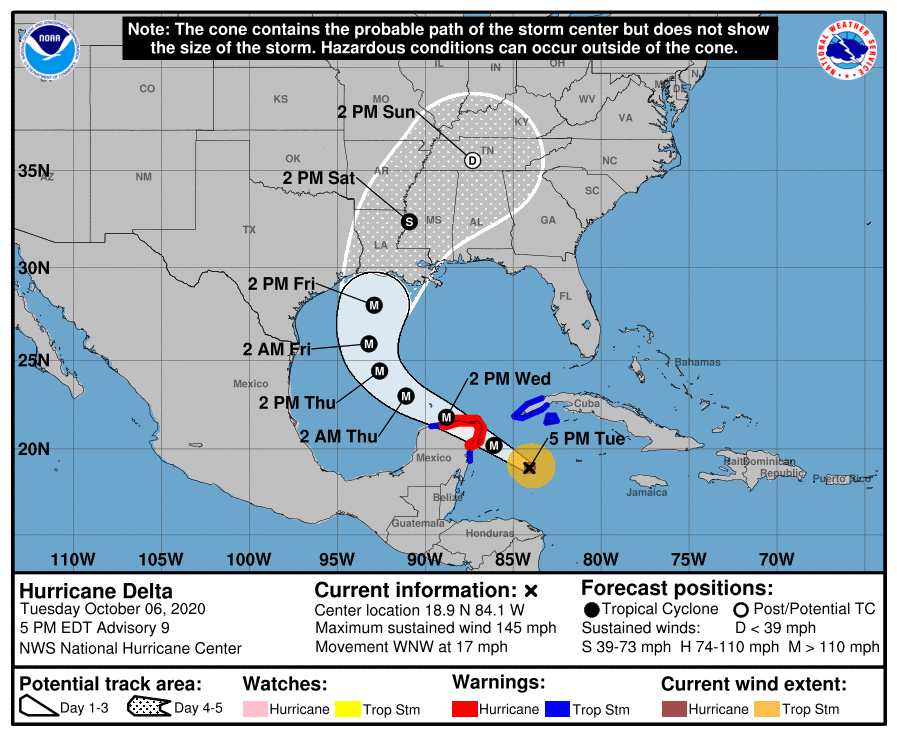
Hurricane Delta is about 200 miles east southeast of Cozumel at this hour. Moving to the WNW at 16 mph, the center will reach the northeastern coast of the Yucatan, near or just south of Cozumel early Wednesday morning.
Top winds are set at 145 mph now. Additional strengthening is possible tonight, and another recon flight is scheduled to investigate this evening.
Tropical storm force winds will begin late this evening, with hurricane force winds during the early morning.
Delta will lose a little steam over the Yucatan, probably decreasing to a category three hurricane again with winds around 120 mph, but wind shear over the Gulf is light water temperatures are still warm, and re-intensification is possible. Delta is forecast to regain Category 4 status with top winds of 130 mph over the Gulf.
By Thursday, the storm will begin encountering colder water and increasing shear and should weaken. However, its wind field is expected to become much larger and it will affect a wide area with strong winds and storm surge. It will remain a dangerous category three hurricane up until landfall it appears with winds of 125 mph when it crosses the coast Friday night.
The official forecast track has been shifted west slightly in response to the models with landfall expected Friday evening around 9 p.m. near the west end of Vermillion Bay. This will bring a devastating storm surge to that region of the Louisiana coast, including Morgan City, Patterson, Franklin, and New Iberia. Storm surge will be high well to the east, including the southeastern Louisiana, Mississippi, Alabama, and western Florida coasts.
The storm will be turning north and northeast ahead of an approaching upper-level trough, so there will be some shifts in the track that could include shifts to the east, so residents along the Gulf Coast from the Upper Texas Coast to the western Florida Panhandle need to pay close attention to the storm.
BULLETIN
Hurricane Delta Advisory Number 9
NWS National Hurricane Center Miami FL AL262020
500 PM EDT Tue Oct 06 2020
…EXTREMELY DANGEROUS CATEGORY FOUR HURRICANE DELTA HEADING
TOWARD THE NORTHEASTERN COAST OF THE YUCATAN PENINSULA…
…EXPECTED TO BRING A LIFE-THREATENING STORM SURGE AND EXTREME
WINDS…
SUMMARY OF 500 PM EDT…2100 UTC…INFORMATION
———————————————-
LOCATION…18.9N 84.1W
ABOUT 215 MI…345 KM ESE OF COZUMEL MEXICO
ABOUT 240 MI…385 KM ESE OF TULUM MEXICO
MAXIMUM SUSTAINED WINDS…145 MPH…230 KM/H
PRESENT MOVEMENT…WNW OR 300 DEGREES AT 17 MPH…28 KM/H
MINIMUM CENTRAL PRESSURE…956 MB…28.23 INCHES
WATCHES AND WARNINGS
——————–
CHANGES WITH THIS ADVISORY:
The government of Cuba has discontinued the Tropical Storm Watch
for the province of La Habana.
SUMMARY OF WATCHES AND WARNINGS IN EFFECT:
A Hurricane Warning is in effect for…
* Tulum to Dzilam Mexico
* Cozumel
A Tropical Storm Warning is in effect for…
* Cuba province of Pinar del Rio
* Isle of Youth
* Punta Herrero to Tulum Mexico
* Dzilam to Progresso Mexico
A Hurricane Warning means that hurricane conditions are expected
somewhere within the warning area. Preparations to protect life
and property should be rushed to completion.
A Tropical Storm Warning means that tropical storm conditions are
expected somewhere within the warning area within 36 hours.
Interests along the northern Gulf of Mexico coast should monitor
the progress of Delta. Hurricane and Storm Surge Watches will
likely be issued for a portion of this area on Wednesday.
For storm information specific to your area, please monitor
products issued by your national meteorological service.
DISCUSSION AND OUTLOOK
———————-
At 500 PM EDT (2100 UTC), the center of Hurricane Delta was located
near latitude 18.9 North, longitude 84.1 West. Delta is moving
toward the west-northwest near 17 mph (28 km/h). A west-
northwestward to northwestward motion is expected over the next
couple of days. A slower northwestward to north-northwestward motion
is forecast to begin on Thursday, and a northward motion is expected
Thursday night and Friday. On the forecast track, the center of
Delta will move over the northeastern portion of the Yucatan
peninsula late tonight or early Wednesday. Delta is forecast to
move over the southern Gulf of Mexico Wednesday afternoon, and be
over the southern or central Gulf of Mexico through Thursday, and
approach the northern Gulf coast on Friday.
Maximum sustained winds have increased to near 145 mph (230 km/h)
with higher gusts. Delta is a category 4 hurricane on the
Saffir-Simpson Hurricane Wind Scale. Some additional strengthening
is possible before the center reaches the coast Yucatan peninsula
Wednesday. Although some weakening is likely when Delta moves over
the Yucatan peninsula, re-strengthening is forecast when the
hurricane moves over the southern Gulf of Mexico Wednesday night and
Thursday.
Hurricane-force winds extend outward up to 30 miles (45 km) from the
center and tropical-storm-force winds extend outward up to 105 miles
(165 km).
The estimated minimum central pressure is 956 mb (28.23 inches).
HAZARDS AFFECTING LAND
———————-
Key messages for Delta can be found in the Tropical Cyclone
Discussion under AWIPS header MIATCDAT1, WMO header WTNT41
KNHC, and on the web at www.hurricanes.gov/text/MIATCDAT1.shtml.
STORM SURGE: A life-threatening storm surge will raise water levels
in areas of onshore winds by as much as 9 to 13 ft above normal tide
levels along the northern coast of the Yucatan Peninsula from Cabo
Catoche to Progresso, and 6 to 9 ft above normal tide levels along
the eastern coast of the Yucatan Peninsula from Tulum to Cabo
Catoche. Near the coast, the surge will be accompanied by large
and destructive waves.
WIND: In the Yucatan Peninsula, potentially catastrophic
hurricane conditions are expected in portions of the warning area
late tonight and early Wednesday, with tropical storm conditions
beginning later this evening. Tropical storm conditions are expected
in the tropical storm warning area tonight and Wednesday. In Cuba,
tropical storm conditions are expected tonight in the warning area.
RAINFALL: Delta is expected to produce 4 to 6 inches of rain, with
isolated maximum totals of 10 inches, across portions of the
northern Yucatan Peninsula through midweek. This rainfall may result
in areas of significant flash flooding.
Over the next few days, Delta is expected to produce 2 to 4 inches
of rain, with isolated higher amounts, across portions of the Cayman
Islands and western Cuba. This rainfall may result in areas of flash
flooding and mudslides.
Later this week, Delta is expected to produce 4 to 8 inches of rain,
with isolated maximum totals of 12 inches to portions of the central
Gulf Coast. These rainfall amounts may lead to flash, urban and
minor river flooding. Heavy rainfall will eventually spread into the
Tennessee Valley, and interior southeastern United States as well.
SURF: Swells generated by Delta will affected land areas around
the northwestern Caribbean Sea for the next day or so. These swells
are likely to cause life-threatening surf and rip current
conditions. Please consult products from your local weather office.
NEXT ADVISORY
————-
Next intermediate advisory at 800 PM EDT.
Next complete advisory at 1100 PM EDT.
$$
Forecaster Brown
About the Author (Author Profile)
Bill Murray is the President of The Weather Factory. He is the site's official weather historian and a weekend forecaster. He also anchors the site's severe weather coverage. Bill Murray is the proud holder of National Weather Association Digital Seal #0001 @wxhistorianSubscribe
If you enjoyed this article, subscribe to receive more just like it.


