7 a.m. Advisory: Hurricane Delta Crossing the Yucatan, Will Reach the Louisiana Coast During the Day Friday
Wind forecast based on official NHC Track
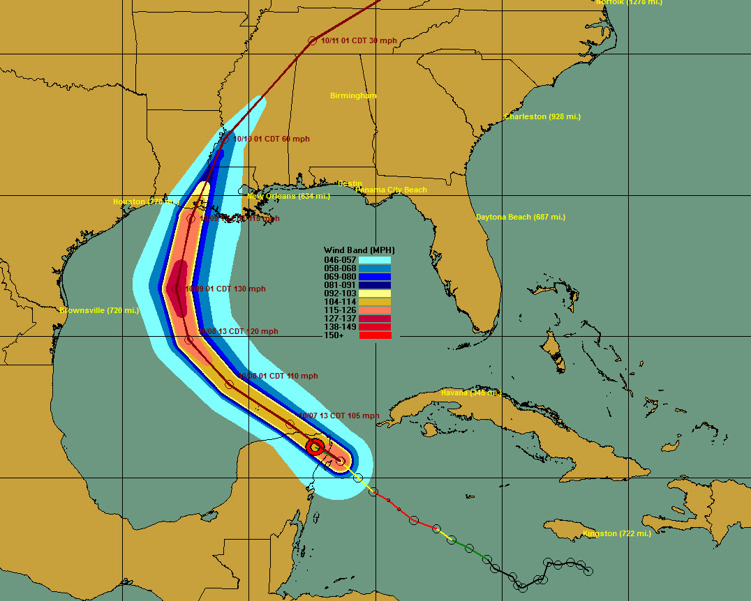
Hurricane Delta is taking a quick trip across the Yucatan Peninsula this morning. It will emerge into the southern Gulf of Mexico by noon and should re-intensify over the warm waters it finds there.
It should become a major hurricane again by Thursday before beginning to weaken Friday as it approaches the coast near Vermillion Bay in Central Louisiana.
It will still be a formidable 115 mph dangerous hurricane at landfall with a life-threatening storm surge, destructive winds, and flooding rains.
The forecast cone has now narrowed and includes an area from Lake Charles to Grand Isle. The Alabama and Northwest Florida coasts are now out of the cone, but not out of the woods. The cone indicates the locations where the CENTER of the storm might be at forecast points in the future. That doesn’t mean impacts won’t be felt well outside the cone for sure.
But for now, confidence is increasing that landfall will occur on the Louisiana Coast on Friday around noon. That is a faster forward speed now.
The storm will be near Vicksburg around midnight Friday night and passing the northwestern corner of Alabama late Saturday night.
We will have frequent updates on the storm throughout the day including its coastal and inland impacts.
BULLETIN
Hurricane Delta Intermediate Advisory Number 11A
NWS National Hurricane Center Miami FL AL262020
700 AM CDT Wed Oct 07 2020
…DELTA BRINGING A LIFE-THREATENING STORM SURGE AND STRONG WINDS
TO NORTHEASTERN PORTIONS OF THE YUCATAN PENINSULA…
SUMMARY OF 700 AM CDT…1200 UTC…INFORMATION
———————————————-
LOCATION…21.1N 87.4W
ABOUT 35 MI…55 KM W OF CANCUN MEXICO
MAXIMUM SUSTAINED WINDS…105 MPH…165 KM/H
PRESENT MOVEMENT…NW OR 305 DEGREES AT 17 MPH…28 KM/H
MINIMUM CENTRAL PRESSURE…974 MB…28.76 INCHES
WATCHES AND WARNINGS
——————–
CHANGES WITH THIS ADVISORY:
None
SUMMARY OF WATCHES AND WARNINGS IN EFFECT:
A Hurricane Warning is in effect for…
* Tulum to Dzilam Mexico
* Cozumel
A Tropical Storm Warning is in effect for…
* Cuba province of Pinar del Rio
* Punta Herrero to Tulum Mexico
* Dzilam to Progreso Mexico
A Hurricane Warning means that hurricane conditions are expected
somewhere within the warning area.
A Tropical Storm Warning means that tropical storm conditions are
expected somewhere within the warning area.
Interests along the northern Gulf of Mexico coast should monitor
the progress of Delta. Hurricane and Storm Surge Watches will
likely be issued for a portion of this area later this morning.
For storm information specific to your area, please monitor
products issued by your national meteorological service.
DISCUSSION AND OUTLOOK
———————-
At 700 AM CDT (1200 UTC), the center of Hurricane Delta was located
by satellite images and surface observation inland over northeastern
Mexico near latitude 21.1 North, longitude 87.4 West. Delta is
moving toward the northwest near 17 mph (28 km/h). A
west-northwestward to northwestward motion is expected over the
next day or so. A slower northwestward to north-northwestward
motion is forecast to begin on Thursday, and a northward motion is
likely Thursday night and Friday. On the forecast track, the
center of Delta will move over the northeastern portion of the
Yucatan Peninsula this morning. Delta is forecast to move over the
southern Gulf of Mexico this afternoon, be over the southern or
central Gulf of Mexico through Thursday, and approach the northern
Gulf coast on Friday.
Maximum sustained winds are near 105 mph (165 km/h) with higher
gusts. Although some additional weakening is likely when Delta
moves over the Yucatan peninsula this morning, re-strengthening is
forecast when the hurricane moves over the southern Gulf of Mexico
Wednesday night and Thursday, and Delta could become a category 4
hurricane again by late Thursday. Weakening is expected as Delta
approaches the northern Gulf coast on Friday.
Hurricane-force winds extend outward up to 30 miles (45 km) from
the center and tropical-storm-force winds extend outward up to 140
miles (220 km). A WeatherFlow observing site at Puerto Morelos,
Mexico, has recently reported sustained winds of 54 mph (87 km/h)
and a gust to 75 mph (122 km/h) after the passage of the center
over that location. A wind gust to 64 mph (104 km/h) was recently
reported on Cozumel, Mexico.
The estimated minimum central pressure based on surface
observations is 974 mb (28.76 inches).
HAZARDS AFFECTING LAND
———————-
Key messages for Delta can be found in the Tropical Cyclone
Discussion under AWIPS header MIATCDAT1, WMO header WTNT41
KNHC, and on the web at www.hurricanes.gov/text/MIATCDAT1.shtml.
STORM SURGE: A life-threatening storm surge will raise water levels
in areas of onshore winds by as much as 6 to 9 ft above normal
tide levels along the northern coast of the Yucatan Peninsula from
Cabo Catoche to Progreso, and 5 to 7 ft above normal tide levels
along the eastern coast of the Yucatan Peninsula from Tulum to Cabo
Catoche. Near the coast, the surge will be accompanied by large
and destructive waves.
WIND: In the Yucatan Peninsula, dangerous hurricane conditions are
expected in portions of the warning area during the next few hours,
with tropical storm conditions already occuring. Tropical storm
conditions are expected in the tropical storm warning area to
continue for the next several hours. In Cuba, tropical storm
conditions could continue over far western portions of the island
during the next few hours.
RAINFALL: Through early Thursday, Delta is expected to produce 4 to
6 inches of rain, with isolated maximum totals of 10 inches, across
portions of the northern Yucatan Peninsula. This rainfall may result
in areas of significant flash flooding. In addition, 2 to 4 inches
of rain, with isolated higher amounts, are expected across portions
of western Cuba. This rainfall may result in areas of flash flooding
and mudslides.
Friday through Saturday, Delta is expected to produce 4 to 8 inches
of rain, with isolated maximum totals of 12 inches across portions
of the central Gulf Coast north into portions of the Lower
Mississippi Valley. These rainfall amounts will lead to flash,
urban, and small stream flooding, along with minor river flooding.
Heavy rainfall will eventually spread into the Tennessee Valley, and
interior southeastern United States this weekend into early next
week.
SURF: Swells generated by Delta will affect land areas around the
northwestern Caribbean Sea for the next day or so. These swells are
likely to cause life-threatening surf and rip current conditions.
Please consult products from your local weather office.
NEXT ADVISORY
————-
Next complete advisory at 1000 AM CDT.
$$
Forecaster Brown
About the Author (Author Profile)
Bill Murray is the President of The Weather Factory. He is the site's official weather historian and a weekend forecaster. He also anchors the site's severe weather coverage. Bill Murray is the proud holder of National Weather Association Digital Seal #0001 @wxhistorianSubscribe
If you enjoyed this article, subscribe to receive more just like it.


