10am Delta Update: Storm Surge & Hurricane Watches Issued for Portions of the Gulf Coast
SUMMARY OF 1000 AM CDT…1500 UTC…INFORMATION
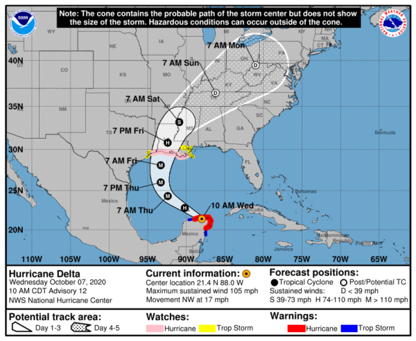
LOCATION…21.4N 88.0W
ABOUT 65 MI…105 KM WSW OF CABO CATOCHE MEXICO
ABOUT 110 MI…175 KM E OF PROGRESO MEXICO
MAXIMUM SUSTAINED WINDS…105 MPH…165 KM/H
PRESENT MOVEMENT…NW OR 305 DEGREES AT 17 MPH…28 KM/H
MINIMUM CENTRAL PRESSURE…975 MB…28.80 INCHES
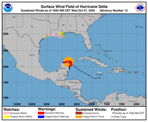
WATCHES AND WARNINGS
A Storm Surge Watch is in effect for…
* High Island, Texas, to the Alabama/Florida border including Calcasieu Lake, Vermilion Bay, Lake Pontchartrain, Lake Maurepas, Lake Borgne, and Mobile Bay
A Hurricane Warning is in effect for…
* Tulum to Dzilam Mexico
* Cozumel
A Hurricane Watch is in effect for…
* High Island Texas to Grand Isle Louisiana
A Tropical Storm Warning is in effect for…
* Punta Herrero to Tulum Mexico
* Dzilam to Progreso Mexico
A Tropical Storm Watch is in effect for…
* San Luis Pass to the west of High Island Texas
* East of Grand Isle Louisiana to Bay St. Louis Mississippi, including New Orleans
* Lake Pontchartrain and Lake Maurepas
DISCUSSION AND OUTLOOK
At 1000 AM CDT (1500 UTC), the center of Hurricane Delta was located near latitude 21.4 North, longitude 88.0 West. Delta is moving toward the northwest near 17 mph (28 km/h). A northwestward motion with a reduction in forward speed is expected over the next 24 hours. A north-northwestward motion is expected by late Thursday, and a faster northward to north-northeastward motion is forecast on Friday and Friday night. On the forecast track, the center of Delta will move over the southern Gulf of Mexico this afternoon, be over the southern or central Gulf of Mexico through Thursday, and approach the northern Gulf coast within the hurricane watch area on Friday.
Maximum sustained winds are near 105 mph (165 km/h) with higher gusts. Re-strengthening is forecast when the hurricane moves over the southern and central Gulf of Mexico through Thursday, and Delta is expected to become a major hurricane again. Some weakening is forecast as Delta approaches the northern Gulf coast on Friday.
Hurricane-force winds extend outward up to 30 miles (45 km) from the center and tropical-storm-force winds extend outward up to 125 miles (205 km).
The estimated minimum central pressure is 975 MB (28.80 inches).
HAZARDS AFFECTING LAND
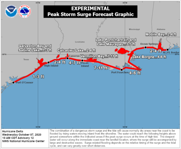
STORM SURGE: A life-threatening storm surge will raise water levels in areas of onshore winds by as much as 6 to 9 ft above normal tide levels along the northern coast of the Yucatan Peninsula from Cabo Catoche to Progreso, and 5 to 7 ft above normal tide levels along the eastern coast of the Yucatan Peninsula from Tulum to Cabo Catoche. Near the coast, the surge will be accompanied by large and destructive waves.
The combination of a dangerous storm surge and the tide will cause normally dry areas near the coast to be flooded by rising waters moving inland from the shoreline. The water could reach the following heights above ground somewhere in the indicated areas if the peak surge occurs at the time of high tide…
Pecan Island, LA to Port Fourchon, LA including Vermilion Bay…7-11 ft
Cameron, LA to Pecan Island, LA…4-7 ft
Port Fourchon, LA to Ocean Springs, MS including Lake Borgne…4-6 ft
Lake Pontchartrain and Lake Maurepas…3-5 ft
Ocean Springs, MS to AL/FL border including Mobile Bay…2-4 ft
High Island, TX to Cameron, LA including Calcasieu Lake…2-4 ft
Sabine Lake…1-3 ft
Port O’Connor, TX to High Island, TX including Galveston Bay…1-3 ft
The deepest water will occur along the immediate coast near and to the east of the landfall location, where the surge will be accompanied by large and dangerous waves. Surge-related flooding depends on the relative timing of the surge and the tidal cycle and can vary greatly over short distances. For information specific to your area, please see products issued by your local National Weather Service forecast office.
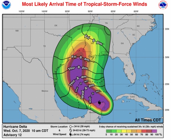
WIND: Hurricane and tropical storm conditions will continue within the warning area in the Yucatan peninsula during the next few hours. Tropical storm conditions are possible within the watch areas along the Gulf Coast by late Thursday night or early Friday with hurricane conditions possible within the hurricane watch area by Friday morning.
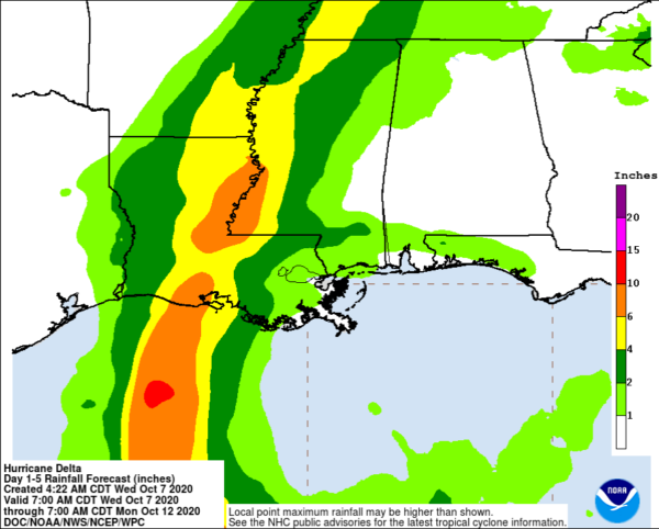
RAINFALL: Through early Thursday, Delta is expected to produce 4 to 6 inches of rain, with isolated maximum totals of 10 inches, across portions of the northern Yucatan Peninsula. This rainfall may result in areas of significant flash flooding.
Friday through Saturday, Delta is expected to produce 4 to 8 inches of rain, with isolated maximum totals of 12 inches across portions of the central Gulf Coast north into portions of the Lower to Middle Mississippi Valley. These rainfall amounts will lead to flash, urban, small stream, and minor river flooding. As Delta moves farther inland, 1 to 3 inches of rain, with locally higher amounts, are expected in the Ohio Valley and Mid Atlantic this weekend.
SURF: Swells generated by Delta will affect land areas around the northwestern Caribbean Sea today. Swell will begin to affect portions of the northern and western Gulf coast on Thursday. These swells are likely to cause life-threatening surf and rip current conditions. Please consult products from your local weather office.
Category: ALL POSTS, Severe Weather, Tropical

