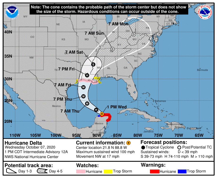
At 1 pm, Delta is a Weak Category 2 Hurricane; Restrengthening is Expected Over the Gulf of Mexico
1:00 PM CDT HURRICANE DELTA SUMMARY
LOCATION…21.8N 88.8W
ABOUT 115 MI…185 KM W OF CABO CATOCHE MEXICO
ABOUT 65 MI…110 KM ENE OF PROGRESO MEXICO
MAXIMUM SUSTAINED WINDS…100 MPH…155 KM/H
PRESENT MOVEMENT…NW OR 305 DEGREES AT 17 MPH…28 KM/H
MINIMUM CENTRAL PRESSURE…975 MB…28.80 INCHES
WATCHES AND WARNINGS
Storm Surge Watch
STORM SURGE WATCH
From High Island, Texas, to the Alabama/Florida border including Calcasieu Lake, Vermilion Bay, Lake Pontchartrain, Lake Maurepas, Lake Borgne, and Mobile Bay.
Hurricane Watch
HURRICANE WATCH
From High Island, Texas, to Grand Isle, Louisiana.
Tropical Storm Watch
TROPICAL STORM WATCH
From San Luis Pass to the west of High Island, Texas, and from east of Grand Isle, Louisiana, to Bay St. Louis, Mississippi, including New Orleans, along with all of Lake Pontchartrain and Lake Maurepas.
DISCUSSION AND OUTLOOK
At 100 PM CDT (1800 UTC), the center of Hurricane Delta was located near latitude 21.8 North, longitude 88.8 West. Delta is moving toward the northwest near 17 mph (28 km/h). A northwestward motion with a reduction in forward speed is expected over the next 24 hours. A north-northwestward motion is expected by late Thursday, and a faster northward to north-northeastward motion is forecast on Friday and Friday night. On the forecast track, the center of Delta will move over the southern Gulf of Mexico this afternoon, be over the southern or central Gulf of Mexico through Thursday, and approach the northern Gulf coast within the hurricane watch area on Friday.
Maximum sustained winds are near 100 mph (155 km/h) with higher gusts. Hurricane-force winds extend outward up to 30 miles from the center and tropical-storm-force winds extend outward up to 125 miles. Restrengthening is forecast when the hurricane moves over the southern and central Gulf of Mexico through Thursday, and Delta is expected to become a major hurricane again. Some weakening is forecast as Delta approaches the northern Gulf coast on Friday. The estimated minimum central pressure is 975 MB (28.80 inches).
HAZARDS AFFECTING LAND
Delta is expected to grow in size as it approaches the northern Gulf Coast, where there is an increasing likelihood of life-threatening storm surge and dangerous hurricane-force winds beginning Friday, particularly for portions of the Louisiana coast. Tropical storm conditions are possible within the watch areas along the Gulf Coast by late Thursday night or early Friday with hurricane conditions possible within the hurricane watch area by Friday morning. Storm Surge, Tropical Storm, and Hurricane Watches are in effect, and residents in these areas should follow the advice given by local officials.
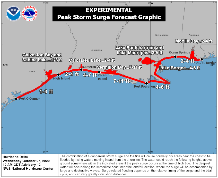
Potential storm surge amounts:
• Pecan Island, LA to Port Fourchon, LA including Vermilion Bay…7-11 ft
• Cameron, LA to Pecan Island, LA…4-7 ft
• Port Fourchon, LA to Ocean Springs, MS including Lake Borgne…4-6 ft
• Lake Pontchartrain and Lake Maurepas…3-5 ft
• Ocean Springs, MS to AL/FL border including Mobile Bay…2-4 ft
• High Island, TX to Cameron, LA including Calcasieu Lake…2-4 ft
• Sabine Lake…1-3 ft
• Port O’Connor, TX to High Island, TX including Galveston Bay…1-3 ft
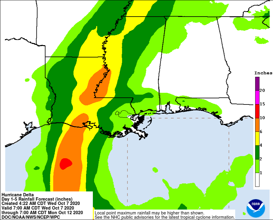
Flash, urban, small stream, and minor river flooding are likely Friday through Saturday from portions of the central Gulf Coast northward into portions of the Lower to Middle Mississippi Valley. As Delta moves farther inland, additional heavy rainfall is expected in the Ohio Valley and Mid Atlantic this weekend.
Swells will begin to affect portions of the northern and western Gulf coast on Thursday. These swells are likely to cause life-threatening surf and rip current conditions.
Category: ALL POSTS, Severe Weather, Tropical
About the Author (Author Profile)
Scott Martin is an operational meteorologist, professional graphic artist, musician, husband, and father. Not only is Scott a member of the National Weather Association, but he is also the Central Alabama Chapter of the NWA president. Scott is also the co-founder of Racecast Weather, which provides forecasts for many racing series across the USA. He also supplies forecasts for the BassMaster Elite Series events including the BassMaster Classic.Subscribe
If you enjoyed this article, subscribe to receive more just like it.


