Landfall Day for Delta: News, Notes and Graphics at 11 a.m.
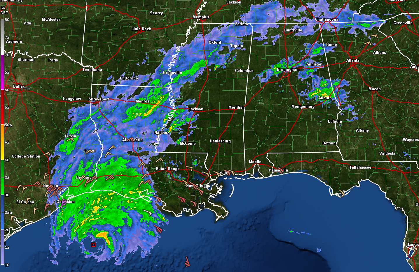
Hurricane Delta is clearly evident in this radar composite of the southern United States, with its large eye 140 miles south-southwest of Lake Charles, LA.
Here is the first Tropical Cyclone Update from the NHC:
Hurricane Delta Tropical Cyclone Update
NWS National Hurricane Center Miami FL AL262020
1100 AM CDT Fri Oct 09 2020
…11 AM CDT POSITION UPDATE…
…TROPICAL STORM CONDITIONS SPREADING ONTO THE UPPER TEXAS
COAST……
A Texas Coastal Ocean Observation Network station at the
Galveston Bay North Jetty recently reported sustained winds of
42 mph (68 km/h) and a wind gust of 49 mph (78 km/h).
SUMMARY OF 1100 AM CDT…1600 UTC…INFORMATION
———————————————–
LOCATION…28.2N 93.7W
ABOUT 110 MI…175 KM SSW OF CAMERON LOUISIANA
MAXIMUM SUSTAINED WINDS…115 MPH…185 KM/H
PRESENT MOVEMENT…N OR 0 DEGREES AT 13 MPH…20 KM/H
MINIMUM CENTRAL PRESSURE…962 MB…28.41 INCHES
$$
Forecaster Beven
Visible satellite imagery shows lots of thunderstorm activity continuing to bubble up around the center, and the GOES global lightning mapper shows a good bit of lightning in those storms.
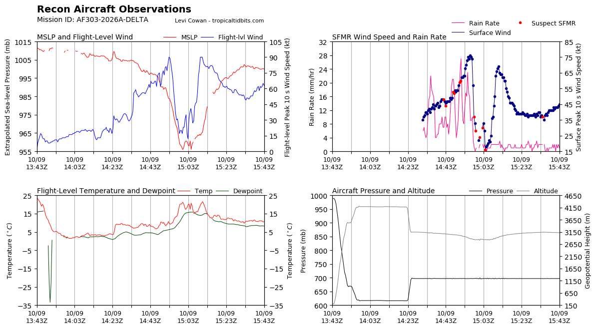
NOAA Hurricane Hunters just penetrated the center from the northwest. Maximum flight level winds were around 90 knots. Surface winds were around 85 mph. The central pressure seems to be steady in the 96–962 mb range. TThe latest fix shows generally a northerly movement over the past few penetrations.
The most recent vortex data message prior to this one indicated that the radar presentation of the eye was deteriorating, indicating some weakening.
An Air force crew is en route to the storm, and there will be another mission later this afternoon.
The model guidance is now tightly clustered and landfall should come around 5-6 p.m. just east of Cameron LA. There were some members of GFS ensembles that had shifted a bit east, so folks in the hurricane warning area from High Island TX to Morgan City LA need to stay alert. Tropical storm warnings extend to the Louisiana/Mississippi border including New Orleans, Lake Ponchartrain, and Lake Maurepas.
Unfortunately, widespread power outages will be experienced across southern Louisiana where the grid has just been rebuilt after Hurricane Laura.
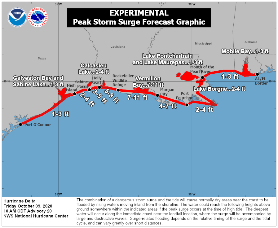
Tides are now 2 feet above normal at Cameron, LA and are 1 foot or more above normal along the rest of the Louisiana coast. A maximum surge of 7-11 feet will occur near and east of the center all the way to Morgan City, and 4-7 feet to Port Fourchon. Tides of 1-3 feet will even impact the Alabama coast.
Even as the storm weakens a bit later today, the surge won’t diminish.
Some coastal reports:
Galveston gusting to 48 mph…thanks to northeasterly flow over Galveston Bay
Beaumont…Heavy Rain…NNE 24 G 36
Lake Charles…Heavy Rain…NE 28 G 39
New Iberia…Light rain..NE 18 G 26
Salt Point…ESE 14 G 31
South Marsh…south of Vermilion Bay…winds gusting to 71 mph
New Orleans…Overcast…ESE 26 G 32
Mobile…Partly Cloudy…E 8
Heavy rain covers southwestern Louisana at this hour. Here is the latest WPC rainfall forecast:
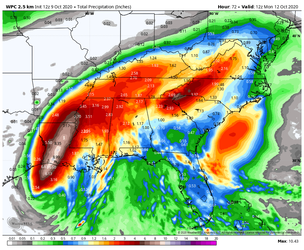
As you can, there will be a tight gradient of rainfall amounts across Alabama for areas northwest of I-59.
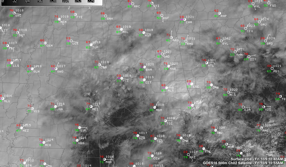
You can see from the radar up top that some light to moderate showers are moving across Central Alabama. A warm front lies across South Alabama, and moist air rising up and above the front is causing this precipitation. Skies are mostly cloudy over Central Alabama, but there are some breaks over southwest sections. Some of that may work up into parts of Central Alabama later today. Temperatures are in the upper 60s over the northern half of the state, with 70s and 80s to the south.
There appears to be an increasing tornado threat for tomorrow for Alabama. These are significant tornado parameter values for tomorrow at 3 p.m. showing conditions favorable for tornadoes in those rainbands that set up tomorrow.
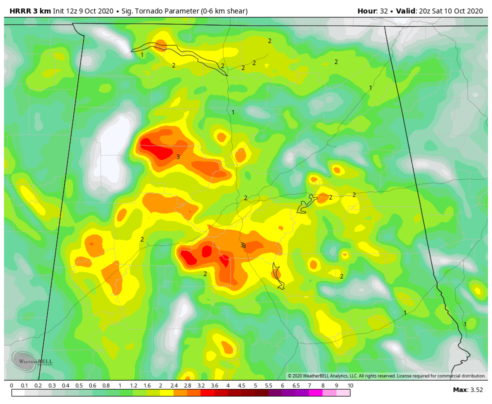
Read Scott’s post coming up shortly for more information about the threat.
You will notice some wind gusts by late this afternoon across Central Alabama, increasing overnight through much of Saturday. Winds tomorrow will average 10-18 mph with gusts to 30 mph at times. The gusty wind winds will continue until early Sunday morning.
The Alabama – Ole Miss game in Oxford has been moved to 6:30 p.m., which should let a lot of the rain and wind leave the area. Expect spitting showers but rain mostly ending, winds averaging 10-15 mph with occasional gusts to 25 mph during the game. Temperatures will be in the upper 60s to near 70.
Auburn will see occasional showers and storms during the game, with a low-end threat of spin-up tornadoes. Temperatures will be in the upper 70s at the start of the game, cooling into the lower 70s. Winds will be out of the SE average 10-15 mph with gusts to 25.
Category: Alabama's Weather, ALL POSTS, Tropical
About the Author (Author Profile)
Bill Murray is the President of The Weather Factory. He is the site's official weather historian and a weekend forecaster. He also anchors the site's severe weather coverage. Bill Murray is the proud holder of National Weather Association Digital Seal #0001 @wxhistorianSubscribe
If you enjoyed this article, subscribe to receive more just like it.


