Sunday Weather Xtreme: Lingering Clouds, A Few Showers Today
Saturday was a rainy, breezy, cool day across Alabama as the remnants of Hurricane Delta approached from the west. There was a threat of tornadoes, but none materialized thankfully. Rainfall amounts were fairly generous with the convective band sweeping across the state, averaging one to two inches. Some spots did pick up 2-3 inches though, with a few locations nearing 4 inches.
SPEAKING OF REMNANTS: The remnants of Hurricane Delta are just a weakening low pressure system moving out of northeastern Alabama into southern Tennessee this morning. The low will slowly move east today, with high pressure to the east only grudgingly giving way. This will keep our skies mostly cloudy most of the day, with some slow clearing area wide by afternoon. A few light showers could develop during the afternoon, but rainfall amounts will be light, and coverage will be very spotty. Temperatures are starting off in the upper 60s over the northern half of the state, with readings near 70F down south. High temperatures will be limited by the cloud cover, with middle 70s North, to upper 70s Central, to lower 80s down south. Winds will be a little breezy, out of the west at 6-14 mph with occasional gusts to 15-20 mph, mainly south. Clouds will probably thicken again overnight, with lows in the middle and upper 60s generally by Monday morning.
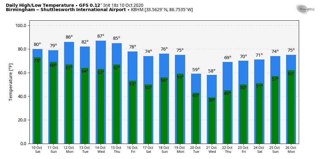
THE WEEK AHEAD: The coming week will be dominated by shortwaves, those little ripples in the upper flow that just eat away at the larger pattern. By the end of the week, they will have carved out a broad trough over much of the country. The first shortwave is going to be swinging through the Great Lakes by Monday and Tuesday, pushing a mostly dry front our way. That front will arrive Monday night, but not before sunshine pushes the warm airmass across our state into the middle and upper 80s for highs that afternoon. Lows Tuesday morning will be in the lower 60s, and Tuesday highs will fall back to between 80-84. We will be back in the 50s for Wednesday morning, and Wednesday afternoon will be just about perfect, with highs in the upper 70s to lower 80s and lots of sunshine. Thursday looks pretty perfect as well, with highs in the middle and upper 70s, and a few readings near 80. Our next shortwave will roll by late Thursday and Friday, bringing a real reinforcing shot of cooler air, but no rain.
WEEKEND OUTLOOK: Expect fall-like conditions for Saturday and Sunday, with lows in the 40s Saturday morning, and lower and middle 50s Sunday morning. Afternoon highs both days will be mainly in the 70s, with a few 60s North on Saturday.
VOODOO TERRITORY: Look for a big, cold trough to develop across the Mississippi Valley by early in the week of the 19th. This spells stormy conditions for Alabama, likely on Tuesday night the 20th. The pattern definitely has a severe weather look, with a warm, moist, and unstable airmass in place across Alabama and the Deep South and a strong cold front sparking storms along with a powerful Jetstream lurking to our northwest. Rainfall amounts could be decent with this system as well, averaging 1-3 inches across the state.
BEACHCAST: After a stormy start to the weekend, the beautiful beaches of Alabama and Northwest Florida will enjoy much-improved weather today and in the days ahead. It will be an absolutely perfect week to be at the beach! Sunny skies will prevail, with highs in the lower and middle 80s. Lows will be in the upper 60s through Tuesday, fall back into the middle 60s for midweek, and then drop into the lower 60s late in the week. Water temperatures are running in the mid 70s. The rip current risk will remain high today but will fall back into the moderate category for the remainder of the week.
Click here to see the Beach Forecast Center page.
NATIONALLY: Fall is the season of strong low-pressure systems across the Rockies, Midwest, and Great Lakes, and a decent one is moving out onto the Northern Plains today. The system has prompted numerous wind advisories and warnings along its track, all the way from the Canadian border to New Mexico.
DANCING WITH THE STATS: Hurricane Delta became the first hurricane carrying a name that starts with the Greek alphabet to make landfall in the United States Friday evening. The category two hurricane made landfall near Creole, LA around 6 p.m., just 12 miles from where Laura made landfall in August. Top winds were 100 mph and the central pressure was 970 mb. Delta was the tenth named storm to hit the U.S., which is a record. In 1916, nine tropical storms and hurricanes hit the U.S. The highest wind measured so far on land was 100 mph at Texas Point, Texas. Lake Charles measured a gust to 96 mph. Gusts to 90 mph were measured at New Iberia, 89 at Cameron, 78 at Beaumont. A wind gust to 61 mph was measured at Alexandria, LA, about 90 miles inland. 9.53 inches of rain fell at Lake Charles, setting a daily record, an October record, and was also the 8th highest daily total ever there. A 17.02 total was measured near Lake Charles. 680,000 people were without power at the peak of the storm.
WEATHERBRAINS: This week, the panel will entertain Dylan Steinkruger from Penn State, who is doing research into Artificial Intelligence and tornado warning production. Check out the show at www.WeatherBrains.com. You can also subscribe on iTunes. You can watch the show live at live.bigbrainsmedia.com or on James’ YouTube Channel You will be able to see the show on the James Spann 24×7 weather channel on cable or directly over the air on the dot 2 feed.
ON THIS DATE IN 1846: The Great Key West Hurricane of 1846 was one of the most significant hurricanes to strike Florida in the 19th century. Great destruction in the Florida Keys. Key West was virtually destroyed with 5 feet of water inundating the city. Two major lighthouses were destroyed by the hurricane. More on that hurricane today on AlabamaWX. Follow my weather history tweets on Twitter. I am @wxhistorian at Twitter.com.
Category: Alabama's Weather, ALL POSTS
About the Author (Author Profile)
Bill Murray is the President of The Weather Factory. He is the site's official weather historian and a weekend forecaster. He also anchors the site's severe weather coverage. Bill Murray is the proud holder of National Weather Association Digital Seal #0001 @wxhistorianSubscribe
If you enjoyed this article, subscribe to receive more just like it.


