As of 4:00 pm, Hurricane & Storm Surge Watches Issued for the Northern Gulf Coast
SUMMARY OF 400 PM CDT…2100 UTC…INFORMATION
———————————————-
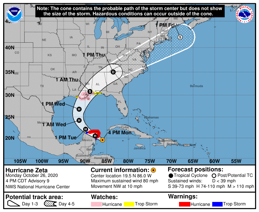
LOCATION…19.5N 86.0W
ABOUT 90 MI…145 KM SE OF COZUMEL MEXICO
MAXIMUM SUSTAINED WINDS…80 MPH…130 KM/H
PRESENT MOVEMENT…NW OR 305 DEGREES AT 10 MPH…17 KM/H
MINIMUM CENTRAL PRESSURE…981 MB…28.97 INCHES
WATCHES AND WARNINGS
——————–
CHANGES WITH THIS ADVISORY:
A Storm Surge Watch is in effect from Intracoastal City, Louisiana,
to Navarre, Florida, including Lake Borgne, Lake Pontchartrain,
Vermilion Bay, Pensacola Bay, and Mobile Bay.
A Hurricane Watch is in effect from Morgan City, Louisiana, to the
Mississippi/Alabama border, including Lake Pontchartrain, Lake
Maurepas, and metropolitan New Orleans.
A Tropical Storm Watch is in effect from the Mississippi/Alabama
border to the Okaloosa/Walton County Line, Florida, and from west
of Morgan City to Intracoastal City.
The government of Cuba has discontinued the Tropical Storm Warning
for Pinar del Rio.
SUMMARY OF WATCHES AND WARNINGS IN EFFECT:
A Hurricane Warning is in effect for…
* Tulum to Dzilam Mexico
* Cozumel
A Tropical Storm Warning is in effect for…
* South of Tulum to Punta Allen Mexico
* West of Dzilam to Progreso Mexico
A Storm Surge Watch is in effect for…
* Intracoastal City Louisiana to Navarre Florida
* Lake Borgne, Lake Pontchartrain, Vermilion Bay, Pensacola Bay, and
Mobile Bay
A Hurricane Watch is in effect for…
* Morgan City Louisiana to the Mississippi/Alabama border
* Lake Pontchartrain, Lake Maurepas, and Metropolitan New Orleans
A Tropical Storm Watch is in effect for…
* Mississippi/Alabama border to Okaloosa/Walton County Line Florida
* West of Morgan City to Intracoastal City Louisiana
DISCUSSION AND OUTLOOK
———————-
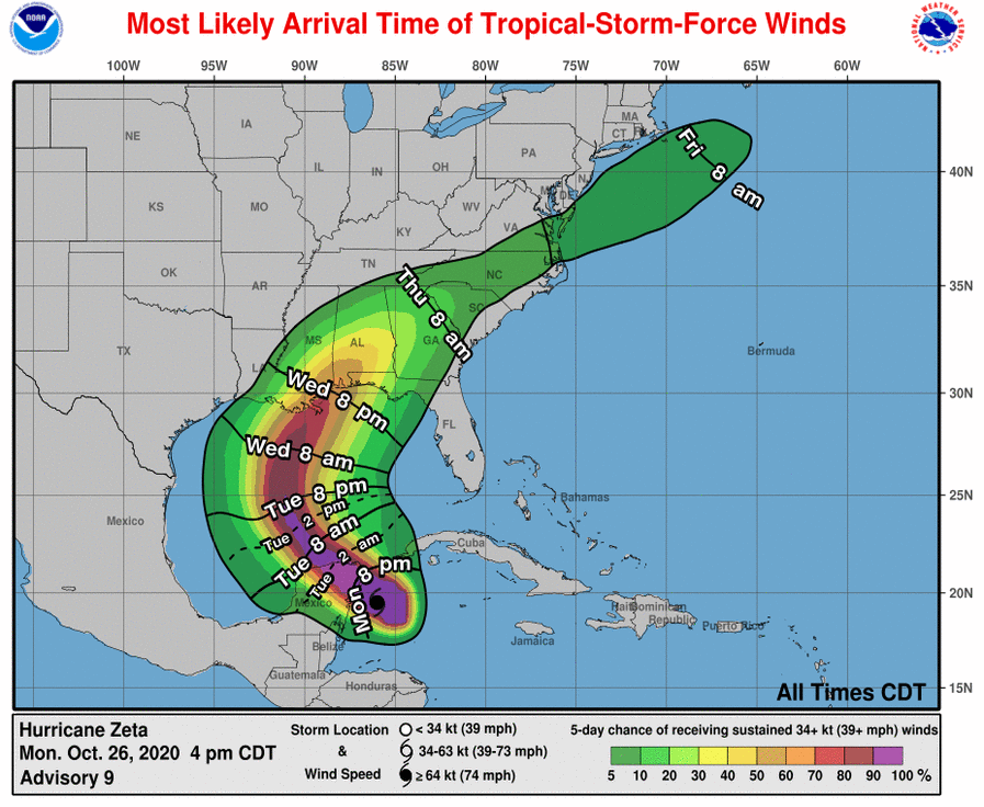
At 400 PM CDT (2100 UTC), the center of Hurricane Zeta was located
near latitude 19.5 North, longitude 86.0 West. Zeta is moving
toward the northwest near 10 mph (17 km/h). A northwestward motion
with some increase in forward speed is expected over the next day or
so, followed by a turn toward the north Tuesday night. A faster
northward to north-northeastward motion is forecast on Wednesday. On
the forecast track, the center of Zeta will move over the northern
Yucatan Peninsula later today or tonight, move over the southern
Gulf of Mexico on Tuesday, and approach the northern Gulf Coast in
the watch area on Wednesday.
Maximum sustained winds are near 80 mph (130 km/h) with higher
gusts. Some additional strengthening is possible before Zeta makes
landfall in the Yucatan Peninsula. Some weakening is likely while
Zeta moves over the Yucatan Peninsula late tonight and early
Tuesday. Zeta is forecast to strengthen again when it moves over
the southern Gulf of Mexico later on Tuesday and be at or near
hurricane strength when it approaches the northern Gulf Coast on
Wednesday.
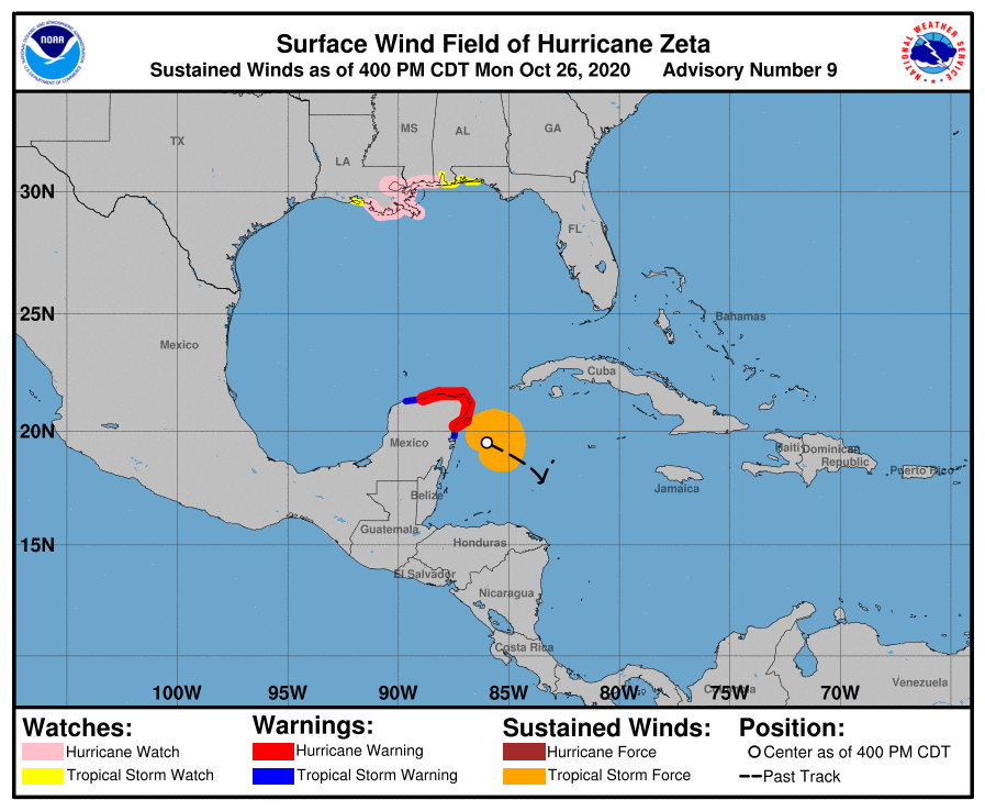
Hurricane-force winds extend outward up to 25 miles (35 km) from the
center and tropical-storm-force winds extend outward up to 115 miles
(185 km).
The estimated minimum central pressure is 981 mb (28.97 inches).
HAZARDS AFFECTING LAND
———————-
Key messages for Zeta can be found in the Tropical Cyclone
Discussion under AWIPS header MIATCDAT3, WMO header WTNT43
KNHC, and on the web at www.hurricanes.gov/text/MIATCDAT3.shtml.
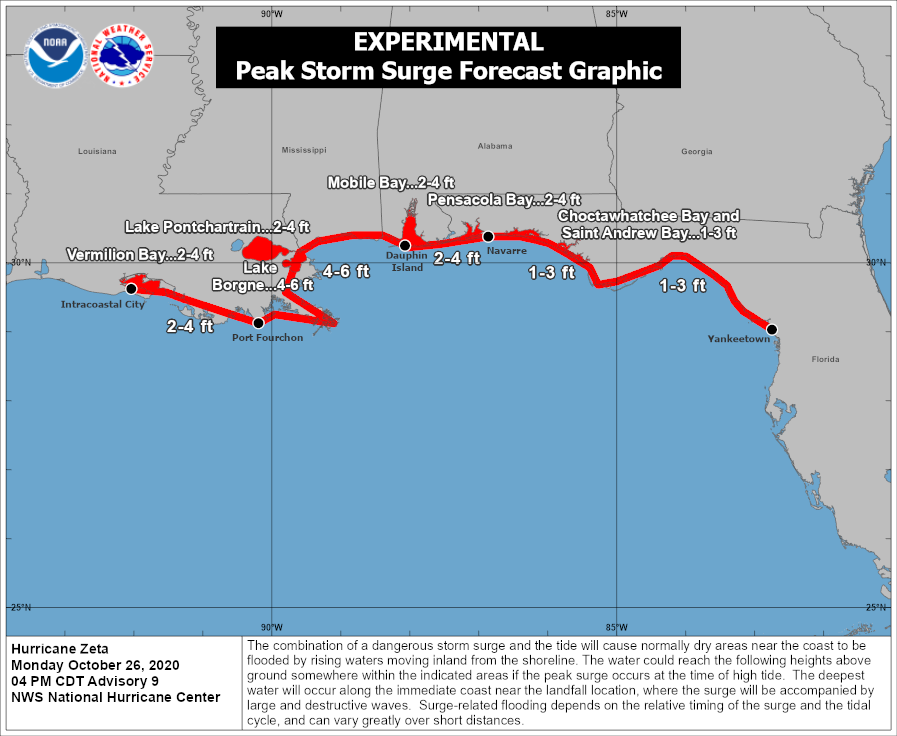
STORM SURGE: A dangerous storm surge will raise water levels by
as much as 2 to 4 feet above normal tide levels along the immediate
coast in the Hurricane Warning area near and to the north of where
the center makes landfall in the Yucatan Peninsula.
The combination of a dangerous storm surge and the tide will cause
normally dry areas near the coast to be flooded by rising waters
moving inland from the shoreline. The water could reach the
following heights above ground somewhere in the indicated areas if
the peak surge occurs at the time of high tide…
Port Fourchon LA to Dauphin Island AL including Lake Borgne…4-6
ft
Intracoastal City LA to Port Fourchon LA including Vermilion
Bay…2-4 ft
Dauphin Island AL to Navarre FL including Mobile Bay and Pensacola
Bay…2-4 ft
Lake Pontchartrain…2-4 ft
Navarre FL to Yankeetown FL including Choctawhatchee Bay and Saint
Andrew Bay…1-3 ft
The deepest water will occur along the immediate coast near and to
the right of the landfall location, where the surge will be
accompanied by large and dangerous waves. Surge-related flooding
depends on the relative timing of the surge and the tidal cycle,
and can vary greatly over short distances. For information
specific to your area, please see products issued by your local
National Weather Service forecast office.
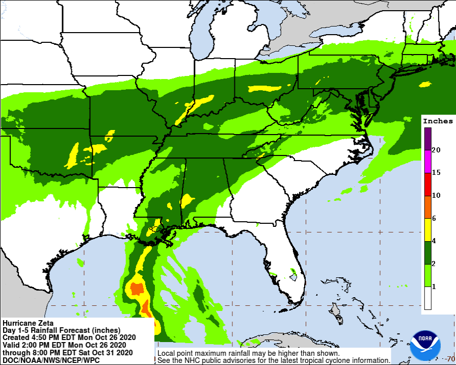
RAINFALL: Rainfall totals of 4 to 8 inches with local amounts of 12
inches are possible through Tuesday along and east-northeast of
Zeta’s track across the Yucatan Peninsula of Mexico, the Cayman
Islands, and central to western Cuba.
An initial area of heavy rains will begin to impact the central Gulf
Coast Tuesday night, spreading north into the Tennessee Valley on
Wednesday. The core of the heavy rains associated with Zeta will
push northeast from eastern Louisiana across southern Mississippi,
Alabama and northern Georgia through Wednesday night, and through
the southern Appalachians into the Mid-Atlantic on Thursday.
Rainfall totals of 2 to 4 inches with isolated amounts of 6 inches
are expected across these areas, resulting in flash, urban, small
stream, and minor river flooding.
WIND: Hurricane conditions are expected within the Hurricane
Warning area in the Yucatan Peninsula this evening. Tropical storm
conditions are expected within the Tropical Storm Warning area in
Mexico this evening.
Hurricane conditions are possible within the Hurricane Watch area on
the northern Gulf Coast late Wednesday, and tropical storm
conditions are possible within the Tropical Storm Watch area on the
northern Gulf Coast late Wednesday.
Category: ALL POSTS, Severe Weather, Tropical
About the Author (Author Profile)
Scott Martin is an operational meteorologist, professional graphic artist, musician, husband, and father. Not only is Scott a member of the National Weather Association, but he is also the Central Alabama Chapter of the NWA president. Scott is also the co-founder of Racecast Weather, which provides forecasts for many racing series across the USA. He also supplies forecasts for the BassMaster Elite Series events including the BassMaster Classic.Subscribe
If you enjoyed this article, subscribe to receive more just like it.


