Coastal impacts from Hurricane Zeta
Preparations should be rushed to completion along the Gulf Coast as a strengthening Hurricane Zeta accelerates toward an afternoon landfall. Tropical storm force winds will begin by early afternoon along the Louisiana coast and between mid-afternoon and sunset on the Alabama, Mississippi, and western Florida Panhandle Coasts.
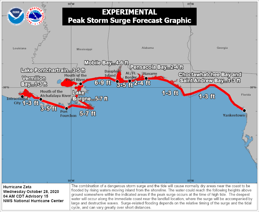
A life-threatening storm surge will impact the coast. Here are expected storm surge heights:
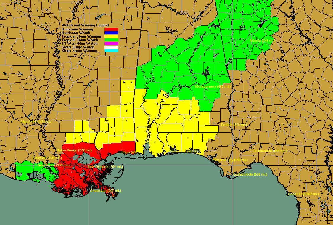
Here are current wind watches and warnings:
Here are some expected coastal impacts:
NEW ORLEANS
Easterly tropical force winds should start affecting the area as early as 2 PM CDT today. The highest wind speeds from Hurricane Zeta should occur near 5 PM CDT when top sustained winds, from the Northeast, could reach 57 MPH with gusts near 69 MPH. Winds should decrease below tropical force after 6 PM CDT and generally be from the Northwest during this period of decreasing winds. Expect gusts above tropical storm force level for several more hours thereafter. Squalls are already occurring and the core of heavy rain will begin moving in around noon in southeastern Louisiana. Rainfall will total 3.6 inches. Areas outside the hurricane protection levees will see 5-7 feet of surge in Plaquemines, St. Bernard, and Terrebonne Parishes with 3-5 feet in Lake Ponchartrain.
MISSISSIPPI GULF COAST
Easterly winds will reach tropical storm force by mid-afternoon today and strong tropical storm force winds will arrive by 6 p.m. The highest wind speeds will occur around 7 p.m. with sustained winds to hurricane force 75-80 mph and gusts to near 86 mph. Rainfall will be around 3.1 inches. A life-threatening storm surge of 6-9 feet will impact the entire Mississippi Coast. Squalls will continue until the main core arrives about mid-afternoon.
MOBILE
Southeasterly tropical storm force winds (39 mph or greater) should start affecting the area by 5 PM CDT with strong tropical force winds (58 mph or greater) arriving around 9 PM CDT. The highest wind speeds from Hurricane Zeta should occur near 9 PM CDT when top sustained winds, from the South, could reach 58 MPH with gusts near 71 MPH. Winds should decrease below tropical storm force after 10 PM CDT and generally be from the Southwest during this period of decreasing winds. Expect gusts above tropical force level for several more hours thereafter. Squalls will occur this morning and afternoon, with the heaviest rain moving in around 6 p.m. Rainfall will total 1.7 inches. Surge in Mobile Bay will be 4-6 feet above normally dry ground.
ALABAMA GULF COAST
DAUPHIN ISLAND
Expect tropical storm force winds by 4 p.m. today out of the southeast. Peak winds will occur around 8 p.m. out of the south at 56 mph with gusts to 67 mph. Winds will drop below tropical storm force by 9 p.m. but expect tropical storm gusts for several additional hours. Surge will reach 6-9 feet above normally dry ground, which will be devastating for the island. Squalls will occur this morning and afternoon, with the heaviest rain moving in around 5 p.m. Rainfall will be 1.4 inches.
GULF SHORES
Expect tropical storm force winds by 5 p.m. with peak winds around 8 p.m. Winds at that time will be out of the south at 50 mph with gusts to 61 mph. Winds will fall below tropical storm force around 10 p..m with gusts for several additional hours. Squalls will occur this morning and afternoon, with the heaviest rain moving in around 6 p.m. Rainfall will total about an inch. Storm surge in Baldwin County outside of Mobile Bay should be 3-5 feet.
PENSACOLA/NAVARRE
Tropical storm force winds will begin around 7 p.m. and end around 10 p..m Peak winds will be out of the south at 40-50 mph with gusts to 54 mph. Surge will be 2-4 feet in Pensacola Bay. Rainfall will be .7 inches in rainbands through the day and overnight.
DESTIN
Winds will reach 30-35 mph what gusts to above 40 mph at Destin. Peak winds should occur around 8 p.m. tonight. There will be a couple of rainbands today with the main line of storms moving through tonight around midnight. Rainfall will total about 0.65 inches. Storm surge should be 1-3 feet.
About the Author (Author Profile)
Bill Murray is the President of The Weather Factory. He is the site's official weather historian and a weekend forecaster. He also anchors the site's severe weather coverage. Bill Murray is the proud holder of National Weather Association Digital Seal #0001 @wxhistorianSubscribe
If you enjoyed this article, subscribe to receive more just like it.


