CANCELED – Flood Warnings Issued for Parts of Colbert, Franklin, Lauderdale, Lawrence, and Limestone, Madison, Morgan Counties Until 1:45
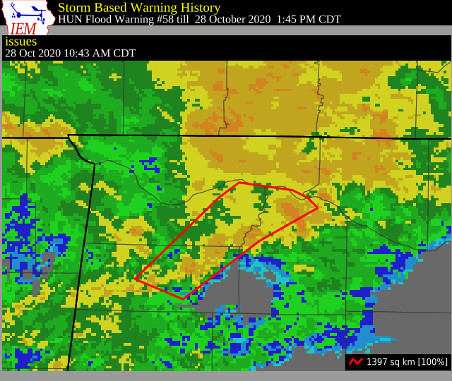
The National Weather Service in Huntsville has issued a
* Flood Warning for…
Southeastern Colbert County in northwestern Alabama…
Eastern Franklin AL County in northwestern Alabama…
Southeastern Lauderdale County in northwestern Alabama…
Northwestern Lawrence County in northwestern Alabama…
* Until 145 PM CDT.
* At 1043 AM CDT, Doppler radar indicated heavy rainfall occurring
across portions of Franklin, Colbert, and Lawrence Counties. Minor
flooding is possible through early this afternoon due to rainfall
repeatedly moving across these locations. Between 2 and 3 inches
of rain have fallen so far this morning.
Some locations that will experience flooding include…
Muscle Shoals, Russellville, Town Creek, Littleville, Leighton,
Courtland, Belgreen, North Courtland, La Grange, Whiteoak,
Tharptown, Colbert Heights, Northwest Alabama Regional Airport,
Ford City, Isbell, Rockwood, Spruce Pine and Red Bank.
PRECAUTIONARY/PREPAREDNESS ACTIONS…
A Flood Warning means that flooding is imminent or occurring. All
interested parties should take necessary precautions immediately.
Excessive runoff from heavy rainfall will cause flooding of small
creeks and streams, country roads, farmland, and other low lying
spots.
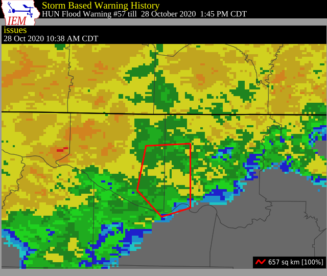
The National Weather Service in Huntsville has issued a
* Flood Warning for…
Southeastern Limestone County in north central Alabama…
Southwestern Madison County in north central Alabama…
East Central Morgan County in north central Alabama…
* Until 145 PM CDT.
* At 1038 AM CDT, Doppler radar and automated rain gauges indicated
minor flooding along Indian Creek in Western Madison County. The
creek is rising rapidly and is expected to crest later this
afternoon. Other locations in Eastern Limestone County south of
Tanner will possibly have minor flooding issues as well,
especially in low lying areas. Between 1 and 3 inches of rain fell
in these areas earlier this morning, and with no heavy rainfall
expected in the next few hours, conditions will improve into the
afternoon.
Some locations that will experience flooding include…
Northwestern Huntsville, Madison, Redstone Arsenal, Triana,
Huntsville International Airport, Marshall Space Flight Center,
Harvest, Mooresville, Capshaw, Belle Mina and French Mill.
PRECAUTIONARY/PREPAREDNESS ACTIONS…
A Flood Warning means that flooding is imminent or occurring. All
interested parties should take necessary precautions immediately.
Excessive runoff from heavy rainfall will cause flooding of small
creeks and streams, urban areas, highways, streets and underpasses
as well as other drainage areas and low lying spots.
Category: Alabama's Weather, ALL POSTS, Severe Weather, Tropical
About the Author (Author Profile)
Scott Martin is an operational meteorologist, professional graphic artist, musician, husband, and father. Not only is Scott a member of the National Weather Association, but he is also the Central Alabama Chapter of the NWA president. Scott is also the co-founder of Racecast Weather, which provides forecasts for many racing series across the USA. He also supplies forecasts for the BassMaster Elite Series events including the BassMaster Classic.Subscribe
If you enjoyed this article, subscribe to receive more just like it.


