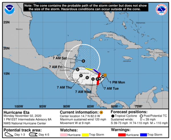
Eta Becomes a Major Hurricane; Life-Threatening Storm Surge, Catastrophic Winds, Flash Flooding, & Landslides Expected Across Portions of Central America.
Hurricane Eta is no threat to Central Alabama or the Alabama Gulf Coast for now. Will have to keep an eye on it after it reemerges off of the northern Honduras coast late on Friday.
SUMMARY OF 100 PM EST…1800 UTC…INFORMATION
———————————————-
LOCATION…14.7N 82.0W
ABOUT 85 MI…135 KM E OF CABO GRACIAS A DIOS ON NIC/HON BORDER
ABOUT 105 MI…170 KM ENE OF PUERTO CABEZAS NICARAGUA
MAXIMUM SUSTAINED WINDS…120 MPH…195 KM/H
PRESENT MOVEMENT…W OR 260 DEGREES AT 9 MPH…15 KM/H
MINIMUM CENTRAL PRESSURE…957 MB…28.26 INCHES
WATCHES AND WARNINGS
——————–
A Hurricane Warning is in effect for…
* The coast of Nicaragua from the Honduras/Nicaragua border to Sandy Bay Sirpi
A Tropical Storm Warning is in effect for…
* The northeastern coast of Honduras from Punta Patuca to the Honduras/Nicaragua border
A Hurricane Watch is in effect for…
* The northeastern coast of Honduras from Punta Patuca to the Honduras/Nicaragua border
A Tropical Storm Watch is in effect for…
* The northern coast of Honduras from west of Punta Patuca westward to Punta Castilla
DISCUSSION AND OUTLOOK
———————-
At 100 PM EST (1800 UTC), the eye of Hurricane Eta was located near latitude 14.7 North, longitude 82.0 West. Eta is moving toward the west near 9 mph (15 km/h). A slower motion toward the west-southwest is forecast this afternoon and will continue into Tuesday. On the forecast track, the center of Eta is expected to approach the northeastern coast of Nicaragua later today and make landfall within the Hurricane Warning area in Nicaragua on Tuesday. The center of Eta is forecast to move farther inland over northern Nicaragua through Wednesday night.
Satellite data indicate that Eta continues to rapidly strengthen. Maximum sustained winds have increased to near 120 mph (195 km/h) with higher gusts. Eta is a category 3 hurricane on the Saffir-Simpson Hurricane Wind Scale. Continued strengthening is expected until Eta reaches the coast of Nicaragua. Weakening will begin after the system moves inland.
Hurricane-force winds extend outward up to 25 miles (35 km) from the center and tropical-storm-force winds extend outward up to 115 miles (185 km).
The estimated minimum central pressure is 957 MB (28.26 inches).
HAZARDS AFFECTING LAND
———————-
WIND: Catastrophic wind damage is expected where Eta’s eyewall moves onshore within the Hurricane Warning area beginning tonight, with tropical storm conditions expected by this afternoon. Tropical storm conditions are expected in the Tropical Storm Warning area by this afternoon, and hurricane conditions are possible in the Hurricane Watch area by early Tuesday. Tropical Storm conditions are possible in the Tropical Storm Watch area by early Tuesday.
RAINFALL: Eta is expected to produce the following rainfall amounts through Friday evening:
- Much of Nicaragua and Honduras: 15 to 25 inches (380 to 635 mm), isolated amounts of 35 inches (890 mm).
- Eastern Guatemala and Belize: 10 to 20 inches (255 to 510 mm), isolated amounts of 25 inches (635 mm).
- Portions of Panama and Costa Rica: 10 to 15 inches (255 to 380 mm), isolated amounts of 25 inches (635 mm).
- Jamaica and southeast Mexico: 5 to 10 inches (125 to 255 mm), isolated amounts of 15 inches (380 mm) over southern areas.
- El Salvador, Southern Haiti, and the Cayman Islands: 3 to 5 inches (75 to 125 mm), isolated amounts of 10 inches (255 mm)
This rainfall would lead to catastrophic, life-threatening flash flooding and river flooding, along with landslides in areas of higher terrain of Central America. Flash flooding and river flooding would be possible across Jamaica, southeast Mexico, El Salvador, southern Haiti, and the Cayman Islands.
STORM SURGE: A dangerous storm surge will raise water levels by as much as 12 to 18 feet above normal tide levels in areas of onshore winds along the coast of Nicaragua within the hurricane warning area, and 3 to 5 feet above normal tide levels along the coast of Honduras within the tropical storm warning area. Near the coast, the surge will be accompanied by large and destructive waves.
SURF: Swells generated by Eta are expected to affect portions of the coast of Central America and the Yucatan Peninsula of Mexico during the next few days. These swells are likely to cause life-threatening surf and rip current conditions.
Category: ALL POSTS, Severe Weather, Tropical


