Updated Mesoscale Discussion from the SPC… Severe Threat Continues
The severe weather threat for Tornado Watch 3 continues.
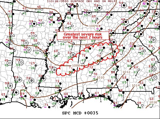
SUMMARY…Severe threat will focus along a corridor from central MS
to extreme northwest GA over the next few hours. The primary risk
will be locally damaging winds along with the threat for a tornado
or two.
DISCUSSION…While large-scale forcing is focused well north of the
central Gulf States, latest satellite imagery suggests deep
convection has intensified over the last hour or so. Cloud-top
evacuation has increased along with lightning flash rates,
indicative of strengthening updrafts. It’s not entirely clear why
this activity has increased, but current trends suggest the greatest
focus for the next few hours will concentrate from central MS,
northeast into northwest GA. Supercells will continue to be a
threat, and at times a few of these may exhibit tornadic signatures.
One particular tornadic supercell that passed just north of BHM has
translated into St. Clair County where it has weakened a bit. This
type of updraft/meso cycling can be expected along the
aforementioned corridor for at least the next few hours.
Category: Alabama's Weather, ALL POSTS, Severe Weather
About the Author (Author Profile)
Scott Martin is an operational meteorologist, professional graphic artist, musician, husband, and father. Not only is Scott a member of the National Weather Association, but he is also the Central Alabama Chapter of the NWA president. Scott is also the co-founder of Racecast Weather, which provides forecasts for many racing series across the USA. He also supplies forecasts for the BassMaster Elite Series events including the BassMaster Classic.Subscribe
If you enjoyed this article, subscribe to receive more just like it.


