Brief Update to North/Central Alabama’s Freezing Rain Event
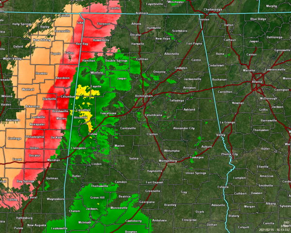
As of 10:18 am, the freezing rain and sleet activity has been retreating a little westward this morning as some warm air advection is taking place and is allowing some locations west of I-65 in the northwestern parts of North/Central Alabama to rise above freezing. Muscle Shoals is the only reporting station at this time that is below freezing. Haleyville, Decatur, Meridianville, and Huntsville are right at the freezing point at 32 degrees. The rest of North/Central Alabama is above freezing. Here is a list of current warnings and advisories in effect for North/Central Alabama:
An ICE STORM WARNING has been issued for the following counties in Central Alabama: Fayette, Lamar, Marion, Pickens, and Winston. The warning is currently in effect and is set to expire at 9:00 pm tonight.
An ICE STORM WARNING has been issued for the following counties in North Alabama: Colbert, Cullman, Franklin, Lauderdale, Lawrence, Limestone, Madison, and Morgan. The warning is currently in effect and is set to expire at 6:00 am Tuesday.
A WINTER STORM WARNING continues for the following counties in Central Alabama: Greene, Sumter, Tuscaloosa, and Walker. The warning is set to expire at 9:00 pm tonight.
A WINTER STORM WARNING continues for the following counties in North Alabama: DeKalb, Jackson, and Marshall. The warning is set to expire at 6:00 am Tuesday.
A WINTER WEATHER ADVISORY has been issued for the following counties in Central Alabama: Bibb, Blount, Jefferson, and Perry. The advisory goes into effect today at 3:00 pm and is set to expire at 9:00 pm tonight.
A HARD FREEZE WARNING has been issued for the following counties in Central Alabama: Autauga, Bibb, Blount, Calhoun, Chambers, Cherokee, Chilton, Clay, Cleburne, Coosa, Dallas, Elmore, Etowah, Fayette, Greene, Hale, Jefferson, Lamar, Lowndes, Marengo, Marion, Montgomery, Perry, Pickens, Randolph, Shelby, St. Clair, Sumter, Talladega, Tallapoosa, Tuscaloosa, Walker, and Winston. The warning goes into effect tonight at 9:00 pm and is set to expire at 11:00 am Tuesday.
A WIND CHILL ADVISORY has been issued for the following counties in Central Alabama: Fayette, Greene, Lamar, Marion, Pickens, Sumter, and Winston. The advisory is set to expire at 9:00 am Tuesday morning.
FOR CENTRAL ALABAMA: The impacts still remain the same across the western half of Central Alabama, but the timing has been adjusted. The freezing rain and sleet activity will be out of the area by 9:00 pm tonight. For the eastern half of the area, temperatures will go below freezing tonight so any leftover wet spots on roadways, bridges, and overpasses will likely freeze.
Tonight’s lows will fall into the upper single digits to the mid-20s across the area from northwest to southeast. Tuesday’s highs will only reach the upper 20s to the lower 40s. Locations along and west of I-65 north of the I-20 corridor may stay below freezing, especially the northwestern locations. Icy conditions may persist until late Wednesday morning or into the early afternoon hours.
FOR NORTH ALABAMA: Freezing rain will continue to affect northwest and north central Alabama and become heavier and more widespread throughout the day. Significant ice accumulations are expected, with light snow and sleet accumulations also possible, especially for far northwest portions of Alabama. This will create widespread hazardous travel conditions and result in some power outages and tree damage.
Over 20 cars have been involved in a single accident near Owens Crossroads on US-231 in Morgan County. Please, if you do not have to be on the roadways today, just don’t travel. Conditions will continue to get worse throughout the day.
Hazardous travel conditions will continue Tuesday through Wednesday morning as temperatures will remain below freezing. This means any ice or snow that accumulated on Monday will stay in place.
Category: Alabama's Weather, ALL POSTS, Winter Weather
About the Author (Author Profile)
Scott Martin is an operational meteorologist, professional graphic artist, musician, husband, and father. Not only is Scott a member of the National Weather Association, but he is also the Central Alabama Chapter of the NWA president. Scott is also the co-founder of Racecast Weather, which provides forecasts for many racing series across the USA. He also supplies forecasts for the BassMaster Elite Series events including the BassMaster Classic.Subscribe
If you enjoyed this article, subscribe to receive more just like it.


