

As We Wait to See What Will Occur for North/Central Alabama, Severe Threat Continues to Our North & West
While we are still waiting to see if a Tornado or Severe Thunderstorm Watch may be issued for portions of North/Central Alabama, the threat for severe weather continues for the Tornado Watch currently in effect for eastern parts of Arkansas through northern parts of Mississippi and into Middle Tennessee. Here is the latest Mesoscale discussion from the SPC:
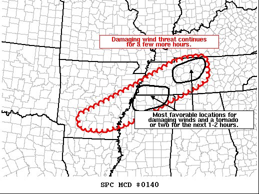
Mesoscale Discussion 0140
NWS Storm Prediction Center Norman OK
0627 PM CST Sun Feb 28, 2021
Areas affected…Eastern Arkansas through northern Mississippi and into Middle Tennessee
Concerning…Tornado Watch 13…
Valid 010027Z – 010200Z
The severe weather threat for Tornado Watch 13 continues.
SUMMARY…A damaging wind threat will continue for a few more hours within tornado watch 13.
DISCUSSION…Storms have struggled to produce much wind damage up to this point. As the boundary layer cools, the favorable window for damaging wind will diminish within a few hours. The most organized cluster of storms is currently north of Memphis, but a sagging outflow boundary from earlier convection continues to rush ahead of this convection and has likely resulted in it remaining somewhat elevated, limiting the overall threat. Some threat will remain, especially south of this outflow boundary, where storms will likely be more surface-based and have a better chance of producing damaging winds.
Another area of favorable conditions exists in north-central Tennessee. A supercell, west of Nashville has exhibited consistent low to mid-level rotation for the last 30 minutes or so. This cell will likely be undercut by the southward moving cold front within the next 30 minutes, but additional convection to the southwest and more discrete cells trying to develop may pose a threat for damaging wind or a tornado or two in the next 1 to 2 hours. The 6:00 pm BNA RAOB shows MLCAPE (instability) around 700 J/kg with effective storm-relative helicity around 270 m2/s2 showing the environment is currently supportive for damaging winds and a tornado or two. However, as the boundary layer cools, inhibition is expected to increase in the next 1 to 2 hours and mitigate the overall threat.
Category: Alabama's Weather, ALL POSTS, Severe Weather
About the Author (Author Profile)
Scott Martin is an operational meteorologist, professional graphic artist, musician, husband, and father. Not only is Scott a member of the National Weather Association, but he is also the Central Alabama Chapter of the NWA president. Scott is also the co-founder of Racecast Weather, which provides forecasts for many racing series across the USA. He also supplies forecasts for the BassMaster Elite Series events including the BassMaster Classic.Subscribe
If you enjoyed this article, subscribe to receive more just like it.


