7:30 a.m. Update on the Alabama Weather Situation
It’s going to be a long St. Patrick’s Day across Alabama as the threat of severe weather impacts all 67 counties today and tonight into early Thursday.
The NWS in Birmingham has canceled the Dense Fog Advisory. Visibilities are still down to one mile at Pell City and Gadsden, 3/4 of a mile at Decatur, 1/2 mile at Bessemer and Alex City, and 1/4 mile at Auburn. Slow down and be careful if you are driving this morning.
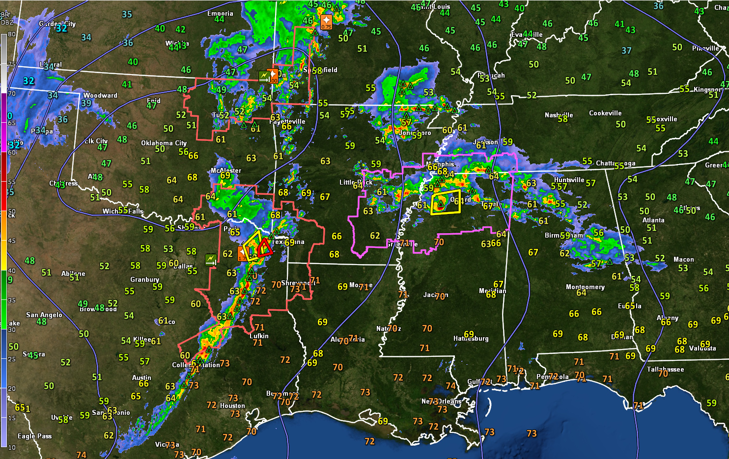
Showers and thunderstorms continue at this hour from Northwest Alabama southeastward into Central Alabama along a warm front. The heaviest activity extends from Franklin County through Winston County, as well as across Coosa and Tallapoosa Counties. The storms are not severe, but they are producing heavy rain and lightning.
That warm front will continue lifting northeastward today, moving out of Northeast Alabama this evening. Right now, areas northeast of the front have temperatures and dewpoints in the 50s, with 60s to the south of the front. It is 70F in Mobile and Jackson MS at this hour. The surface low is just east of Oklahoma City. It will be near Fayetteville, Arkansas by 7 p.m. this evening with a cold front approaching the Mississippi River.
A tornado watch covers northern Mississippi, southwestern Tennessee, and eastern Arkansas this morning. It will be in effect until 1 p.m. The threat for tornadoes in the watch area will increase this morning, including the threat of a couple of intense tornadoes. There is currently a severe thunderstorm warning for a strong complex of storms approaching Batesville in northwestern Mississippi. Radar indicates one-inch hail with these storms, and they earlier prompted a Tornado Warning for Bolivar County, Mississippi.
To the west, there is a Severe Thunderstorm Watch for parts of northeastern Oklahoma, southeastern Kansas, and southwestern Missouri until 8 a.m. Strong storms extend from west of Springfield, Missouri to near Tulsa at this hour. There have been recent reports of wind damage along this line. Another Severe Thunderstorm Watch is in effect until 10 a.m. for Southeast Oklahoma, Southwest Arkansas, and Northeast Texas. A Tornado Warning is in effect now for areas around Mount Pleasant, Texas.
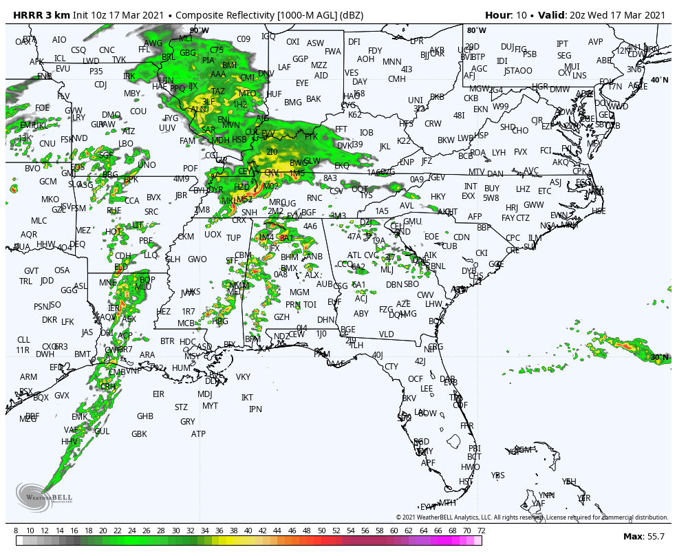
The storms along the warm front will continue lifting northward through the morning. Then by early afternoon, storms will start forming across North and Central Alabama. Here is the HRRR depiction of what the radar might look like around 3 p.m.
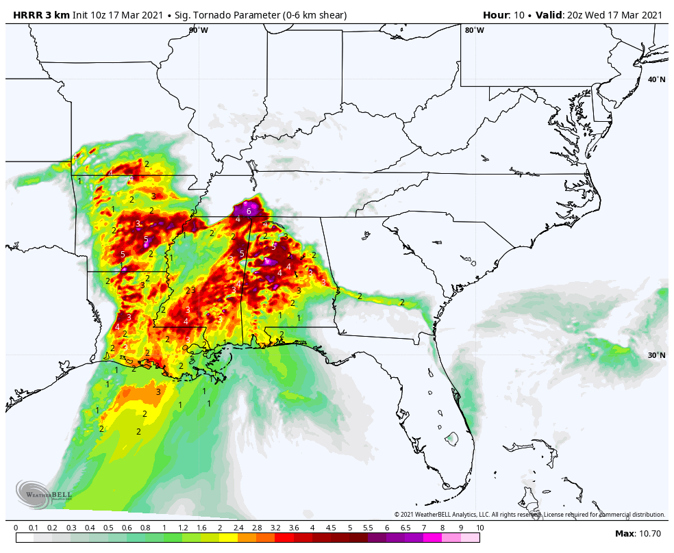
These storms will continue into the evening and could become severe with the potential of producing tornadoes. CAPE values by mid-afternoon could be approaching 3,000 joules/kg, which is quite unstable and with adequate low-level helicity values between 150-200 m2/s2, tornadoes are likely. Significant Tornado Parameter values are between 2-5 across much of Central Alabama by 3 p.m.
These storms will continue into the evening hours with the tornado threat remaining high.
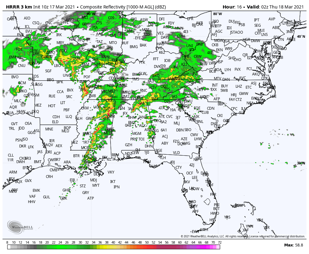
By early evening, we will be watching storms approaching West Alabama. Here is the HRRR at 9 p.m. showing intense storms approaching the Alabama/Mississippi border, with severe storms still ongoing across Northeast Alabama.
Again, Significant Tornado Parameter values will be high across eastern Mississippi and much of Central Alabama. The threat of intense, long-track tornadoes will be high across eastern Mississippi into West Central Alabama as this activity moves into the state. Here is the STP at 9 p.m.
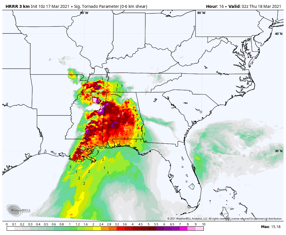
It appears this activity will move through our western counties between 9 p.m. and midnight and the I-65 Corridor in the 11 p.m. – 2 a.m. time frame, and into eastern Alabama after 1 a.m. We will continue to fine-tune these times as we go through the day.
So it is imperative that you have multiple ways to receive warnings reliably overnight. Review your severe weather safety plan. We have a comprehensive list of severe weather safety tips here.
If you’re reading this blog, you are a Weather Ambassador. Make sure you let your friends, family, neighbors, and co-workers that may be less weather savvy know about the threat.
Category: Alabama's Weather, ALL POSTS, Severe Weather
About the Author (Author Profile)
Bill Murray is the President of The Weather Factory. He is the site's official weather historian and a weekend forecaster. He also anchors the site's severe weather coverage. Bill Murray is the proud holder of National Weather Association Digital Seal #0001 @wxhistorianSubscribe
If you enjoyed this article, subscribe to receive more just like it.


