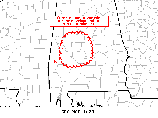
Corridor in Southwestern Parts of the Area Favorable for Strong Tornado Development
SUMMARY…
A corridor more favorable for the development of strong tornadoes may be evolving across central AL.
DISCUSSION…
Radar imagery from BMX, GWX, and MOB continues to show a cluster of supercells over west-central AL. The downstream air mass is characterized by temperatures in the low/mid 70s and dewpoints in the upper 60s. As noted in the recent BMX sounding, this air mass is less buoyant than farther west (along the central MS/AL border) where this cluster initially developed. However, in contrast to the slightly less favorable thermodynamics, surface winds here are more southeasterly, veering to southerly in the low-levels, and then southwesterly farther aloft. This is resulting in considerable low-level vertical shear. Recent VAD profile from BMX sampled 350+ m2/s2 of 0-1 km storm-relative helicity. Given the already organized character of these storms, potential exists for the development of strong tornadoes if a more discrete nature can be maintained.
Category: Alabama's Weather, ALL POSTS, Severe Weather
About the Author (Author Profile)
Scott Martin is an operational meteorologist, professional graphic artist, musician, husband, and father. Not only is Scott a member of the National Weather Association, but he is also the Central Alabama Chapter of the NWA president. Scott is also the co-founder of Racecast Weather, which provides forecasts for many racing series across the USA. He also supplies forecasts for the BassMaster Elite Series events including the BassMaster Classic.Subscribe
If you enjoyed this article, subscribe to receive more just like it.


