New Tornado Warning for Central Tuscaloosa County
We have multiple dangerous storms ongoing now.
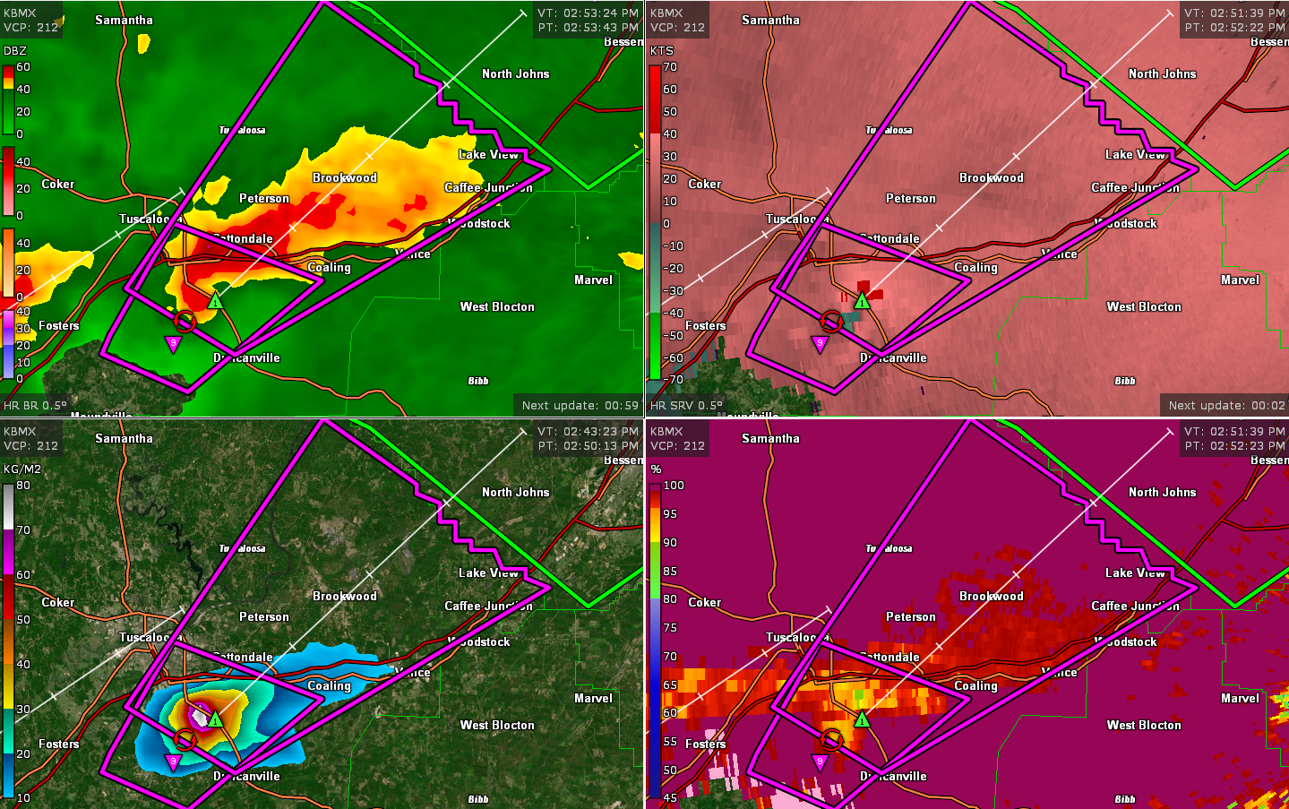
One of those is passing just east of the City of Tuscaloosa. It will cross I-59 shortly.
It has produced confirmed tornado damage south of Tuscaloosa.
The tornado will move toward Cottondale, Coaling, Peterson, and Brookwood.
Heads up western Jefferson County around Hueytow, Oak Grove, Pleasant Grove and other communities in that area.
THE NATIONAL WEATHER SERVICE IN BIRMINGHAM HAS ISSUED A
* TORNADO WARNING FOR…
CENTRAL TUSCALOOSA COUNTY IN WEST CENTRAL ALABAMA…
* UNTIL 345 PM CDT.
* AT 253 PM CDT, A CONFIRMED TORNADO WAS LOCATED NEAR MCFARLAND MALL,
OR 7 MILES SOUTHEAST OF TUSCALOOSA, MOVING NORTHEAST AT 30 MPH.
HAZARD…DAMAGING TORNADO AND PING PONG BALL SIZE HAIL.
SOURCE…PUBLIC CONFIRMED TORNADO.
IMPACT…FLYING DEBRIS WILL BE DANGEROUS TO THOSE CAUGHT WITHOUT
SHELTER. MOBILE HOMES WILL BE DAMAGED OR DESTROYED.
DAMAGE TO ROOFS, WINDOWS, AND VEHICLES WILL OCCUR. TREE
DAMAGE IS LIKELY.
* LOCATIONS IMPACTED INCLUDE…
TUSCALOOSA, HOLT, LAKE VIEW, BROOKWOOD, COALING, VANCE, ABERNANT,
MCFARLAND MALL, LAKE WILDWOOD, UNIVERSITY MALL, DEERLICK CREEK
CAMPGROUNDS, MERCEDES BENZ OF ALABAMA, SHELTON STATE COMMUNITY
COLLEGE, NORTH BIBB, COTTONDALE, EAST BROOKWOOD, PETERSON, LAKE
HARRIS, CAFFEE JUNCTION AND FLEETWOOD.
Category: Alabama's Weather, ALL POSTS, Severe Weather
About the Author (Author Profile)
Bill Murray is the President of The Weather Factory. He is the site's official weather historian and a weekend forecaster. He also anchors the site's severe weather coverage. Bill Murray is the proud holder of National Weather Association Digital Seal #0001 @wxhistorianSubscribe
If you enjoyed this article, subscribe to receive more just like it.


