Tornado Watch Potentially Coming By Early Afternoon to Portions of North/Central Alabama
From the latest SPC Mesoscale Discussion:
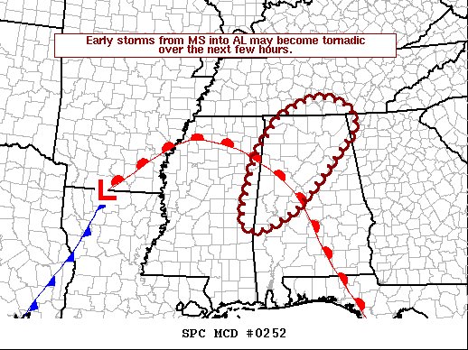
SUMMARY… Ongoing storms from Mississippi into Alabama may consolidate into supercells through midday with developing tornado threat. A tornado watch is likely by early afternoon.
DISCUSSION… Ongoing activity over eastern MS and into AL has been elevated for much of the morning, but cells now extend southwest of the warm front which is situated from from northern MS into central AL. Radar trends show that cells within these areas have acquired rotation as they attempt to transition from elevated to surface based. This may happen over the next couple hours as temperatures warm into the 70s F with the warm front lifting north, maximizing effective SRH. Therefore, it is possible that these cells develop a tornado threat over the next few hours. 0-1 km SRH of 300-400 m2/s2 along the warm front will favor strong tornadoes as the stronger instability develops into the warm advection zone.
Category: Alabama's Weather, ALL POSTS, Severe Weather
About the Author (Author Profile)
Scott Martin is an operational meteorologist, professional graphic artist, musician, husband, and father. Not only is Scott a member of the National Weather Association, but he is also the Central Alabama Chapter of the NWA president. Scott is also the co-founder of Racecast Weather, which provides forecasts for many racing series across the USA. He also supplies forecasts for the BassMaster Elite Series events including the BassMaster Classic.Subscribe
If you enjoyed this article, subscribe to receive more just like it.


