Localized Mesoscale Discussion Concerning Tuscaloosa Co. Tornado
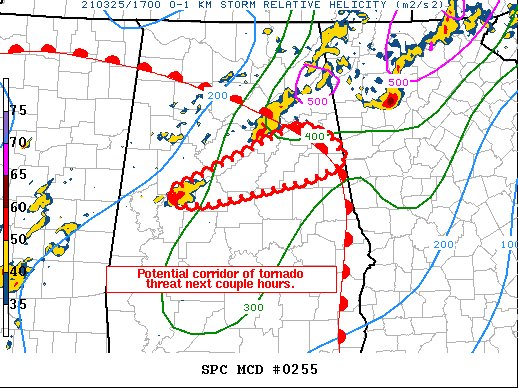
SUMMARY… A tornadic supercell over northern Hale County may persist
with tornado threat expanding east/northeast for several hours.
DISCUSSION… A long-lived supercell, now tornadic and likely
producing a strong tornado, continues to move east/northeast across
northern Hale County, and has shown no signs of weakening.
The air mass ahead of this cell is unstable and warming as the warm
front continues to lift well northeast of the Birmingham area.
Latest VWP out of BMX shows 0-1 SRH of 329 m2/s2 given a motion of
245/38 kt, which supports a strong tornado.
Given warm/moist advection east of the cell, the tornado threat may
persist for a couple hours as it moves east/northeast across several
counties in Alabama.
Category: Alabama's Weather, ALL POSTS, Severe Weather
About the Author (Author Profile)
Scott Martin is an operational meteorologist, professional graphic artist, musician, husband, and father. Not only is Scott a member of the National Weather Association, but he is also the Central Alabama Chapter of the NWA president. Scott is also the co-founder of Racecast Weather, which provides forecasts for many racing series across the USA. He also supplies forecasts for the BassMaster Elite Series events including the BassMaster Classic.Subscribe
If you enjoyed this article, subscribe to receive more just like it.


